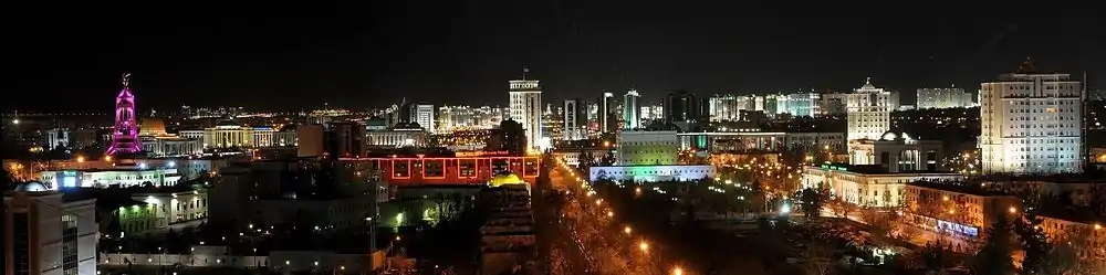
Ashgabat
Ashgabat (Turkmen: Aşgabat; Ашгабат, pronounced [ɑʃʁɑˈbɑt],[3] Persian: عشق آباد; Russian: Ашхабад), formerly named Poltoratsk (Russian: Полтора́цк, IPA: [pəltɐˈratsk]) between 1919 and 1927, is the capital and the largest city of Turkmenistan. It is situated between the Karakum Desert and the Kopet Dag mountain range in Central Asia. It is also near the Iran-Turkmenistan border.
Ashgabat
Aşgabat (in Turkmen) Konjikala (2nd Century B.C.-circa 1830) Askhabad (circa 1830–1919) Асхабадъ (in Russian) Poltoratsk (1919–1927) Полторацк (in Russian) Ashkhabad (1927–1991) Ашхабад (in Russian) | |
|---|---|
 .jpg.webp) 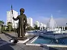 .jpg.webp) .jpg.webp) .jpg.webp) 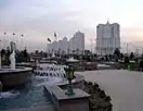  | |
.svg.png.webp) Seal | |
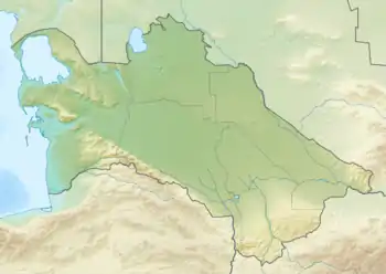 Ashgabat Location of Ashgabat in Turkmenistan  Ashgabat Ashgabat (Asia) | |
| Coordinates: 37°56′N 58°22′E | |
| Country | |
| Founded | 1881 |
| Government | |
| • Type | Presidential[1] |
| • Mayor | Ýaztagan Gylyjow[2] |
| Area | |
| • Total | 440 km2 (170 sq mi) |
| Elevation | 219 m (719 ft) |
| Population (2012) | |
| • Total | 1,031,992 |
| • Density | 2,300/km2 (6,100/sq mi) |
| Time zone | UTC+05:00 |
| • Summer (DST) | UTC+05:00 (not observed) |
| Postal code | 744000–744040 |
| Area code(s) | (+993) 12 |
| Vehicle registration | AG |
| Website | www.ashgabat.gov.tm |
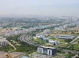
The city was founded in 1881 on the basis of an Ahal Teke tribal village, and made the capital of the Turkmen Soviet Socialist Republic in 1924. Much of the city was destroyed by the 1948 Ashgabat earthquake but has since been extensively rebuilt under the rule of Saparmurat Niyazov’s "White City" urban renewal project,[4] resulting in monumental projects sheathed in costly white marble.[5] The Soviet-era Karakum Canal runs through the city, carrying waters from the Amu Darya from east to west.[6] Since 2019, the city has been recognized as having one of the highest costs of living in the world largely due to Turkmenistan's inflation and import issues.[7][8]
Names
.jpg.webp)
Ashgabat is called Aşgabat in Turkmen, (Russian: Ашхабад, romanized: Ashkhabad) in Russian from 1925 to 1991, and Ešq-ābād (عشقآباد) in Persian. Before 1991, the city was usually spelled Ashkhabad in English, a transliteration of the Russian form. It has also been variously spelled Ashkhabat and Ashgabad. From 1919 until 1927, the city was renamed Poltoratsk after a local revolutionary, Pavel Gerasimovich Poltoratskiy.[9]
Although the name literally means "city of love" or "city of devotion" in modern Persian, the name might be modified through folk etymology. Turkmen historian Ovez Gundogdiyev believes that the name goes back to the Parthian era, 3rd century BC, deriving from the name of the founder of the Parthian Empire, Arsaces I of Parthia, in Persian Ashk-Abad (the city of Ashk/Arsaces).[10]
Geography
Ashgabat is very close to the border with Iran.[11] It occupies a highly seismically active oasis plain bounded on the south by the foothills of the Kopet Dag mountains (Turkmen: Köpetdag) and on the north by the Karakum Desert. It is surrounded by, but not part of, Ahal Province (Turkmen: Ahal welaýaty). The highest point in the city is the 401 metres (1,316 ft) high sandhill upon which the Yyldyz Hotel was built, but most of the city lies between 200 and 255 metres (656 and 837 ft) of elevation. The Karakum Canal runs through the city.[12][13][14]
Like the rest of Turkmenistan, Ashgabat's soil is primarily sediment that accumulated on the bottom of the Tethys Ocean. The Kopet Dag mountains emerged toward the end of the Cretaceous Period.[15]
Click this link for the OpenStreetMap map of Ashgabat.
Urban layout
Prior to 1881 any buildings other than yurts were made solely from adobe and were limited to one story in height due to the seismic risk.[16] City planning began following the Russian conquest, with "very simple planning schemes." The basic layout of downtown streets "has been preserved to this day and defined the unique character of the city structure combining linear and radial types of layout of blocks." The Russian writer Vasily Yan, who lived in Askhabad from 1901 to 1904, described the city as "a little tidy town consisting of numerous clay houses, surrounded by fruit gardens with straight streets, planted with slim cottonwood, chestnut, and white acacia planned by the hand of military engineers."[17] Another description noted,
- The fortress was the center of the bureaucratic part of the city. Here stood especially sturdy thick-walled houses, with strong window grates and corner buttresses. Earthquakes were less frightening in such houses, and behind the thick walls even in the hottest months some measure of indoor coolness was retained. Each house had a garden around it, on maintenance of which residents spared neither expenditures nor water...Nearer the rail station lived the railroad workers and craftsmen. Here the houses were shorter and more densely spaced, gardens smaller, and dust on the streets greater...
- Gradually a third center of Ashkhabad started to emerge, of the merchants. Roughly equidistant from the rail station and the fortress was laid out a sad marketplace, becoming not only a center of stores and stalls, but a center of gravity for merchants' residence.[18]
The 1930s
The first master plan for Ashgabat, developed between 1935 and 1937 at the Moscow Institute of Geodesy, Aerial Imagery, and Cartography, envisioned expansion to the west, including irrigation and greening of the Bikrova canyon (today Bekrewe).[14] The city architect's office was created in 1936 but was unable to implement the new master plan "as it implied significant demolition of the existing buildings."[19] A description of Ashgabat published in 1948 just before the earthquake noted, "In Ashgabat there are nearly no tall buildings, thus every two-story building is visible from above...", i.e., from the foothills. The tallest structures were the clock tower of the textile mill, the "round smokestack of the glass factory", two "exceptionally thin minarets" of the "former mosque", and "two splendid towers over the long building of the main city hotel."[18]
Impact of the 1948 Earthquake
During the 1948 earthquake, since the bulk of Ashgabat at that time was built of either adobe or fired brick, all but a very few buildings collapsed or were damaged beyond repair (the reinforced concrete grain elevator, Church of St. Alexander Nevsky, and Kärz Bank were among the structures that survived).[20][21] According to Turkmenistan's official news agency,
- Nearly all one-story residential buildings in the city made of mud brick were destroyed, 95 percent of all one-story buildings made of fired brick, and the remaining structures were damaged beyond repair. The number of inhabitable buildings was in single digits, and at that, only after capital renovation.[19]
A new general plan was hastily developed by July 1949. The city was divided into four zones: central, northern, eastern, and southwestern. Reconstruction of the city began in that year.[14][19] Thus from the early 1950s through 1991 Ashgabat's skyline was dominated by the Brutalist Style favored by post-Stalin Soviet architects.[22] The city's central avenue, Magtymguly (former Kuropatkin, Freedom, and Stalin Prospect) featured "monotonous and primarily two-story construction of administrative and residential buildings." This reconstruction "preserved the existing network of city streets as it was economically unjustified to redesign them."[19] The city was described as "...a Communist-era backwater, rebuilt into a typically drab provincial Soviet city..."[23]
Among the buildings erected in the 1950s and 1960s were the headquarters of the Central Committee of the Turkmenistan Communist Party, the Council of Ministers Building, the Mollanepes Academic Drama Theater, the former Ashkhabad Hotel (now renamed Paytagt), the Academy of Sciences complex, and the downtown library building. On then-Karl Marx Square stood a monument to the Soviet "fighters for victory of Soviet power in Turkmenistan".[14]
The 1960s Master Plan
The Turkmen State Project Institute undertook a feasibility study in the mid-1960s to forecast Ashgabat's development to the year 2000, and on that basis to develop a new master plan. Up until then the city had largely expanded to the east, but now the plan called for development to the south and west. This plan was used for about 20 years, and led to construction of the city's first four-story apartment buildings in the Howdan (Russian: Гаудан) microdistricts, formerly the site of the Ashgabat-South aerodrome, as well as annexation of three collective farms in the near suburbs and their conversion into residential neighborhoods, one of which, Leningrad kolkhoz, to this day is referred to informally by its former name.[19][24] The plan was reworked in 1974, and this resulted in relocation of several industrial plants away from the city center, and thus creation of the industrial zones to the northwest, south, southeast, and northeast.[14]
Growth
In 1948 Ashgabat was described before the earthquake as lying "on a sloping plain of the Kopet-Dag foothills, stretching seven kilometers from west to east and five kilometers from the railroad right-of-way to the south, in the direction of the mountains."[18] Through the mid-1970s, Ashgabat was a compact city, as shown by the 1974 Soviet military's General Staff map J-40-081.[25] The village of Köşi, collective farm "Leningrad", airport, and suburbs to the north were outside the city limits.
Beginning in the 1970s, Ashgabat's boundaries shifted outward, with the aforementioned municipalities annexed, the aerodrome at Howdan redeveloped, and creation of the Parahat (Russian: Mir) neighborhoods to the south and industrial parks to the east. In 2013, Ashgabat annexed a portion of the then-Ruhabat district of Ahal Province as well as the city of Abadan (previously named Büzmeýin, and renamed that as a neighborhood) plus all land and villages in between. The southern boundary of Ashgabat was extended southward to the foothills of the Kopet Dag mountains. Overall, Ashgabat's land area rose by 37,654 hectares. The following municipalities were abolished due to their incorporation into the city of Ashgabat: city of Abadan, towns of Jülge and Ruhabat, villages of Gökje, Gypjak, Birleşik, Magaryf, Herrikgala, Ýalkym, Gurtly, Hellewler, Ylmy-Tejribe bazasy, Ýasmansalyk, Köne Gurtly, Gulantäzekli, Serdar ýoly, Gaňtar, Gyzyljagala, Inerçýage, Tarhan, Topurly, and Ussagulla. [26][27][28] A further expansion occurred January 5, 2018, when additional land to the north was annexed, incorporating the Gurtly Reservoir and two greenfield residential construction projects, known today as Täze Zaman. This statute also established the current four boroughs of Ashgabat.[29][30]
Climate
The Kopet Dag mountain range is about 25 kilometres (16 mi) to the south, and Ashgabat's northern boundary touches the Kara-Kum desert. Because of this Ashgabat has a cold desert climate (Köppen climate classification: BWk, bordering from BWh) with very hot, dry summers and cool, short winters. The average high temperature in July is 38.3 °C (100.9 °F). Nighttimes in the summer are warm, with an average minimum temperature in July of 23.8 °C (75 °F). The average January high temperature is 8.6 °C (47.5 °F), and the average low temperature is −0.4 °C (31.3 °F). The highest temperature ever recorded in Ashgabat is 47.2 °C (117 °F), recorded in June 2015.[31] A low temperature of −24.1 °C (−11 °F) was recorded in January 1969.[31] Snow is infrequent in the area. Annual precipitation is only 201 millimetres (7.91 in); March and April are the wettest months, and summer drought, from late June to September, is virtually absolute.
| Ashgabat | ||||||||||||||||||||||||||||||||||||||||||||||||||||||||||||
|---|---|---|---|---|---|---|---|---|---|---|---|---|---|---|---|---|---|---|---|---|---|---|---|---|---|---|---|---|---|---|---|---|---|---|---|---|---|---|---|---|---|---|---|---|---|---|---|---|---|---|---|---|---|---|---|---|---|---|---|---|
| Climate chart (explanation) | ||||||||||||||||||||||||||||||||||||||||||||||||||||||||||||
| ||||||||||||||||||||||||||||||||||||||||||||||||||||||||||||
| ||||||||||||||||||||||||||||||||||||||||||||||||||||||||||||
| Climate data for Ashgabat | |||||||||||||
|---|---|---|---|---|---|---|---|---|---|---|---|---|---|
| Month | Jan | Feb | Mar | Apr | May | Jun | Jul | Aug | Sep | Oct | Nov | Dec | Year |
| Record high °C (°F) | 28.7 (83.7) |
32.6 (90.7) |
38.6 (101.5) |
39.4 (102.9) |
44.5 (112.1) |
47.2 (117.0) |
46.0 (114.8) |
45.7 (114.3) |
45.6 (114.1) |
40.1 (104.2) |
37.0 (98.6) |
33.1 (91.6) |
47.2 (117.0) |
| Average high °C (°F) | 8.6 (47.5) |
11.2 (52.2) |
16.5 (61.7) |
24.1 (75.4) |
30.1 (86.2) |
36.0 (96.8) |
38.3 (100.9) |
37.2 (99.0) |
31.7 (89.1) |
24.3 (75.7) |
16.8 (62.2) |
10.4 (50.7) |
23.8 (74.8) |
| Daily mean °C (°F) | 3.5 (38.3) |
5.5 (41.9) |
10.4 (50.7) |
17.4 (63.3) |
23.3 (73.9) |
29.0 (84.2) |
31.3 (88.3) |
29.6 (85.3) |
23.6 (74.5) |
16.5 (61.7) |
10.2 (50.4) |
5.1 (41.2) |
17.1 (62.8) |
| Average low °C (°F) | −0.4 (31.3) |
1.0 (33.8) |
5.5 (41.9) |
11.6 (52.9) |
16.6 (61.9) |
21.5 (70.7) |
23.8 (74.8) |
21.7 (71.1) |
16.1 (61.0) |
10.1 (50.2) |
5.2 (41.4) |
1.2 (34.2) |
11.2 (52.2) |
| Record low °C (°F) | −24.1 (−11.4) |
−20.8 (−5.4) |
−13.3 (8.1) |
−0.8 (30.6) |
1.3 (34.3) |
9.2 (48.6) |
13.8 (56.8) |
9.5 (49.1) |
2.0 (35.6) |
−5.1 (22.8) |
−13.1 (8.4) |
−16 (3) |
−24.1 (−11.4) |
| Average precipitation mm (inches) | 20 (0.8) |
24 (0.9) |
41 (1.6) |
32 (1.3) |
21 (0.8) |
6 (0.2) |
3 (0.1) |
2 (0.1) |
3 (0.1) |
10 (0.4) |
19 (0.7) |
20 (0.8) |
201 (7.9) |
| Average rainy days | 9 | 9 | 13 | 12 | 10 | 5 | 3 | 2 | 3 | 6 | 8 | 10 | 90 |
| Average snowy days | 5 | 5 | 1 | 0.03 | 0 | 0 | 0 | 0 | 0 | 0.1 | 1 | 3 | 15 |
| Average relative humidity (%) | 78 | 72 | 66 | 58 | 47 | 35 | 34 | 34 | 40 | 54 | 68 | 77 | 55 |
| Mean monthly sunshine hours | 112.7 | 119.4 | 146.2 | 194.4 | 275.1 | 335.5 | 353.8 | 348.1 | 289.2 | 216.8 | 157.2 | 104.4 | 2,652.8 |
| Source 1: Pogoda.ru.net[32] | |||||||||||||
| Source 2: NOAA (sun, 1961–1990)[33] | |||||||||||||
History
Ashgabat grew on the ruins of the Silk Road city of Konjikala, first mentioned as a wine-producing village in the 2nd century BC and leveled by an earthquake in the 1st century BC (a precursor of the 1948 Ashgabat earthquake). Konjikala was rebuilt because of its advantageous location on the Silk Road and it flourished until its destruction by Mongols in the 13th century. After that it survived as a small village until Russians took over in the 19th century.[34][35]
The near suburb of Köşi, until 2013 a separate village but in that year annexed by Ashgabat, may have been site of a Parthian fortress constructed to protect the capital city, Nisa, based on discoveries of pottery and other artifacts in the 1970s and as recently as 2020. Other artifacts indicating settlement during the Parthian period were reportedly discovered during laying of telephone cables on the site of the Gülistan (Russian) Bazaar in downtown Ashgabat.[36]
British Lieutenant Colonel H.C. Stuart reported in 1881 that the Ahal branch of the Teke tribe of the Turkmen ethnic group arrived in the area around 1830 and established several semi-nomadic villages (auls) between what are now the city of Serdar and village of Gäwers, inclusive. One of these villages was named Askhabad.[37] The first written reference to Ashgabat dates to 1850, in a document kept in the Russian Ministry of Foreign Affairs archives listing 43 Ahal fortresses, "Ishkhabad" among them.[17] It was described as a "typical Turkmen aul".[18]
It was formally part of Persia but de facto autonomous under Turkoman tribal control until Russian forces defeated the Teke army at the Battle of Geok Tepe in January 1881. Persia ceded Askhabad to the Russian Empire under the terms of the Akhal Treaty. The city was officially founded January 18, 1881, as a fortified garrison and was named after the Turkmen village on that site.[18][38][14] Russian military engineers platted the garrison settlement "on the western edge of the aul (village) of Askhabad on the Gaudan (Howdan) road leading to Persia. The fortress stood on a hill 12 meters high, on which was constructed a citadel-redoubt, and below [it], the residential area, surrounded by walls and a moat."[14] Russia developed the area due to its proximity to the border of British-influenced Persia. The Trans-Caspian railway reached Askhabad in 1886. The population grew from 2,500 in 1881 to 19,428 (of whom one third were Persian) by 1897.[39]
The city was regarded as a pleasant municipality with European-style buildings, shops, and hotels. Several streets were named after Russian military figures, reflecting its status as a garrison town, including the main square, named in honor of General Mikhail Skobelev, commander of Russian forces during the 1880–1881 Trans-Caspian military campaign. These included as well the western boundary avenue, named in honor of General Nikolai Grodekov, and the city's central avenue, renamed in the 1890s to honor General and Trans-Caspian Governor-General Aleksey Kuropatkin, both of whom had served in the Trans-Caspian campaign under Skobolev's command.[40]
In 1908, the first Bahá'í House of Worship was built in Askhabad. It was badly damaged in the 1948 earthquake and finally demolished in 1963.[41][42] The community of the Bahá'í Faith in Turkmenistan was largely based in Askhabad.
By 1915 Askhabad featured branches of the Russian State Bank, Persian Accounting Loan Bank, Russian-Asian Bank, Société Générale, and Askhabat Mutual Credit Union.[17]
Soviet period
Soviet rule was established in Ashgabat in December 1917. However, in July 1918, a coalition of Mensheviks, Social Revolutionaries, and Tsarist former officers of the Imperial Russian Army revolted against the Bolshevik rule emanating from Tashkent and established the Ashkhabad Executive Committee. After receiving some support (but even more promises) from General Malleson, the British withdrew in April 1919 and the Tashkent Soviet resumed control of the city.
In 1919, the city was renamed Poltoratsk (Russian: Полторацк), after Pavel Poltoratskiy, the Chairman of the Soviet of National Economy of the Turkestan Autonomous Soviet Socialist Republic.[38][43] When the Turkmen SSR was established in 1924, Poltoratsk became its capital. The original name but in the form of "Ashkhabad" rather than "Askhabad" was restored in 1927.[38] In keeping with standard Soviet practice, Imperial Russian street names were changed to honor prominent Communists, Russians, or socialist ideals. For example, Skobolev Square became Karl Marx Square, Grodekov Street became Ostrovskiy Street, and Kuropatkin Prospect became Freedom Prospect (and from 1953 to 1961, following Joseph Stalin's death, Stalin Prospect).[44][45] In 1927 a statue of Vladimir Lenin designed by A.A. Karelin and Ye.R. Tripolskaya was erected.[14]
From this period onward, the city experienced rapid growth and industrialisation, although severely disrupted by a major earthquake on October 6, 1948. An estimated 7.3 on the Richter scale, the earthquake killed 110–176,000[46][47][48][49] (⅔ of the population of the city), although the official number announced by Soviet news was only 40,000.[50]
Independence
In July 2003, street names in Ashgabat were replaced by serial numbers except for nine major highways, some named after Saparmurat Niyazov, his father, and his mother. The Presidential Palace Square was designated 2000 to symbolize the beginning of the 21st century. The rest of the streets were assigned larger or smaller four-digit numerical names. Following Niyazov's death in 2006, Soviet-era street names were restored, though in the years since, many of them have been replaced with names honoring Turkmen scholars, poets, military heroes, and figures from art and culture, as well as celebrating the nation's independence. For example, Karl Marx Square became Garaşsyzlyk (Independence) Square, Ostrovskiy Street became Abba Annaýew (in honor of President Gurbanguly Berdimuhamedov's great-uncle), and Freedom Prospect became Magtymguly.[44][45][51][52]
In 2013, the city was included in the Guinness Book of Records as possessing the world's highest concentration of white marble buildings.[53]
Ashgabat's "11th Line" project was dedicated on June 29, 2012, including 17 high-rise apartment buildings along 10 ýyl Abadançylyk şaýoly, two secondary schools, two kindergartens, a fire station, and a health clinic.[54] The "12th Line" project was completed October 1, 2014, consisting of a straightening and widening of Atamyrat Nyýazow şaýoly plus construction of 13 high-rise apartment buildings, two secondary schools, two kindergartens, a new headquarters building for the Union of Industrialists and Entrepreneurs, the Telekeçi shopping center, and the Development Bank. On that same date, the new Cabinet of Ministers building was also opened.[55]
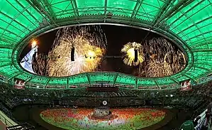
In preparation for the 2017 Asian Indoor and Martial Arts Games, the city spent $6 billion on residential construction. December 4, 2014, the president issued a decree calling for construction of 60 9-story apartment buildings in the Parahat-7 microdistrict, a greenfield project in the southeast quadrant of the city.[56] On November 10, 2015, the "13th Line" was dedicated, a complete reconstruction of buildings along Oguzhan köçesi west of Garaşsyzlyk şaýoly.[57] Projects included demolition and redevelopment of the Leningrad kolkhoz neighborhood as the "14th Line", and the Gazha and Vosmushka neighborhoods as the "15th Line".[44][58][59][60][61]
Subsequent to conclusion of the Asian Indoor and Martial Arts Games, the "16th Line" project, a redevelopment of the Köşi neighborhood and extension of Magtymguly Prospect to the west, was begun in 2018.[62][63] The "16th Line" was dedicated on November 10, 2020; it includes 16 high-rise apartment buildings, the Gül zemin shopping center, and a monument to the Alabay sheepdog.[64] In addition, the Gurtly and Choganly housing complexes, both greenfield projects, were constructed.[65][66][67]
The largest current residential project is construction of "Ashgabat-City" (Turkmen: Aşgabat-siti) north of the Choganly residential neighborhood, which is planned to include over 200 buildings on 744 hectares, and for the first time in the city's history to feature some buildings as tall as 35 stories.[68][69][70][71][72]
Ashgabat milestones:[73]
- 1882–1918 – administrative center of Russia's Transcaspian Region
- 1918–1925 – administrative center of the Turkmen Oblast in the Turkestan Autonomous Soviet Socialist Republic
- since February 1925 – capital of the Turkmen Soviet Socialist Republic
- since October 1991 – capital of independent Turkmenistan
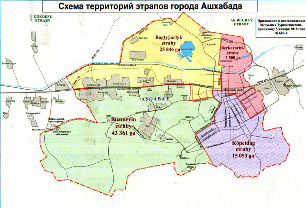
Districts
See also Map of the Boroughs of Ashgabat
As of January 5, 2018, Ashgabat includes four boroughs (uly etraplar), each with a presidentially appointed mayor (Turkmen: häkim):[1][74][75][76][77][78][79]
- Bagtyýarlyk etraby (formerly President Niyazov, Lenin District, expanded to include former Ruhabat District plus new territory)
- Berkararlyk etraby (formerly Azatlyk, Sovetskiy District)
- Büzmeýin etraby (formerly Abadan District, expanded to include former Arçabil and Çandybil Districts)
- Köpetdag etraby (formerly Proletarskiy District)
This is a reduction from the previous number of boroughs. Arçabil and Çandybil boroughs were merged on February 4, 2015, and the new etrap, named Arçabil, was in turn renamed Büzmeýin in January 2018. At that time the Abadan borough of Ashgabat, created in 2013 by annexing the town of Abadan and surrounding villages to Abadan's south, was abolished and its territory was merged into the newly renamed Büzmeýin borough. The former Ruhabat borough was abolished at the same time and its territory absorbed by Bagtyýarlyk borough.[80]
On 15 June 2020, Turkmen President Gurbanguly Berdimuhamedov announced intention to create a fifth borough of Ashgabat, to be called Altyn etraby, centered on the new resort zone created on the shores of the former Gurtly Water Reservoir, recently renamed "Golden Lake" (Altyn köl).[81]
Demographics
In 1871 a Russian visitor named Strebnitskiy counted over four thousand "nomad tents" (yurts), implying a population of 16 to 20 thousand Ahal Teke Turkmen, many of whom were killed or dispersed in the 1881 Battle of Geok Tepe. The population was 2,500 in 1881, virtually all Russian.[82] By 1886 Askhabad's population was about 10,000, mainly ethnic Russians.[17][14] Construction of the Trans-Caspian Railway stimulated an influx of migrants seeking employment, particularly from the Caucasus, Volga Valley, and Iran, and Askhabad's subsequent population growth was as follows:
1897: 19,426
1908: 39,867
1911: 45,384
Ethnic Russians dominated the population after 1881, with about 20 percent admixture of Caucasus-origin migrants (mainly Armenians), but "very few" Turkmen.[14][18] One source indicates that pre-revolutionary Askhabad had no Turkmen residents at all, and that they lived in nearby auls.[18] This began to change in the 1920s, following imposition of Soviet power, which brought with it forced collectivization. In 1926 Ashkhabad's population of 51,593 included 52.4% Russians, 11.3% Armenians, 4.3% Persians, 2.2% Turkmen, and 29.8% "other". By 1939, Ashkhabad counted 126,500 residents, including 11.7% Turkmen. The 1959 census recorded a population of 169,900, which grew to 338,000 by 1983, including 105 nationalities, of which ethnic Turkmen constituted 40 percent.[14]
According to estimates of the 2012 Turkmen census the Turkmen form 77% of the city's population. Russians form 10% of the population, followed by Armenians (1.5%), Turks (1.1%), Uzbeks (1.1%), and Azeris (1%).[83]
Architecture
Post-1991
Following independence in 1991, President Saparmurat Niyazov began hiring foreign architectural and construction firms, most prominently Bouygues of France and the Turkish firms Polimeks and Gap Inşaat, the latter a subsidiary of Çalık Holding. These firms blended Persian-style domes, which Niyazov favored, with Greco-Roman architectural elements such as pillars.[84][85][86][87][88]
Following Niyazov's death, domes began to go out of fashion for buildings other than mosques, and public buildings began to take on more modernist characteristics, often with a motif reflecting the structure's intended occupant. For example, the Ministry of Foreign Affairs building is topped by a globe of the Earth, inside which is a conference center; the Development Bank building is topped by a giant coin; the Ministry of Health and Medical Industry building is shaped like a stylized caduceus, the dental hospital is shaped like a molar and the international terminal of Ashgabat International Airport is shaped like a falcon.[89] The dominant characteristic of new construction since 1991 has been nearly universal facing with white marble.[90][16] Another recurring motif is the eight-pointed star of Oguz Khan, the largest of which is on the television tower and has entered the Guinness Book of World Records.[91][92][93] The official Turkmen government guide book to Ashgabat refers to the star of Oguz Khan as "...the basic dominant of the whole architectural-art decor..."[17]
After independence, the city architect's office ordered construction of many high-rise (generally 12-story) residential buildings. Modern construction techniques allow high-rise development with good seismic safety. Primarily consisting of residential towers, the first floor is typically used as retail space and for building maintenance.[16]
Monuments and statues
Ashgabat features many sculptures honoring Turkmen, Turkic, and other Islamic poets and heroes. Four statues, of Lenin, Alexander Pushkin, Taras Shevchenko, and Magtymguly, date to the Soviet period, as do a statue and a bust of Turkmen composer Nury Halmammedov. Since then, however, much new sculpture has appeared. In Ylham (Inspiration) Park are found numerous busts and statues. Additional statues can be seen in the VDNH Park. A monumental statue of the current president was dedicated in May 2015 near Ashgabat Stadium. One also finds statues of Mustafa Kemal Atatürk and Alp Arslan. In addition to the statue of former President Niyazov atop the Neutrality Monument, a gilded statue of him stands before the Ministry of Internal Affairs, and a gilded seated statue of him graces the entry to the Turkmen Agricultural University.
Since independence in 1991, several monuments to features of Turkmenistan's governance have been erected: to neutrality, to the constitution, to the renaissance of Turkmenistan, to independence, as well as a special monument to former President Saparmurat Niyazov's magnum opus, Ruhnama.
The memorial complex in Bekrewe includes a statue of a bull with the Earth balanced on its horns, symbolizing the 1948 earthquake, and a statue of two traditionally dressed Turkmen warriors guarding a widow grieving the death of her husband in World War II. The exterior wall of the museum features bas reliefs depicting events in Turkmenistan's history.
In advance of the V Asian Indoor and Martial Arts Games held in September 2017, roughly one billion dollars was spent on widening and upgrading Ashgabat's major thoroughfares.[44] Several traffic circles were created, in which were placed mainly abstract monuments. As of 2020 the most recent addition to these are the Bicycle Monument (Turkmen: Welosiped binasy), which President Berdimuhamedov dedicated on June 3, 2020, and the Turkmen Alabay monument, dedicated on November 10, 2020.[94][95]
Controversies
Much of the urban renewal since 1991 has involved demolition of traditional single-family residential housing, commonly with allegedly forced eviction of residents, and often without compensation to the homeowners. In particular, private homes rebuilt in neighborhoods flattened by the 1948 earthquake, many of which were never formally registered with the government, were subject to confiscation and demolition without compensation, as were former dacha communities like Ruhabat, Berzengi, and Choganly, which in nearly all cases lacked formal ownership documents.[96][97][98][99][100][101]
First Baha'i Temple in the world
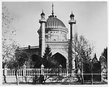
When Ashgabat was under Russian rule, the number of Bahá'ís in the city rose to over 1,000, and a Bahá'í community was established, with its own schools, medical facilities and cemetery. The community elected one of the first Bahá'í local administrative institutions. In 1908 the Bahá'í community completed the construction of the first Bahá'í House of Worship, sometimes referred to by its Arabic name of mašriqu-l-'aḏkār (Arabic: مشرق اﻻذكار),[102] where people of all religions may worship God without denominational restrictions.[103] The building was designed under the guidance of `Abdu'l-Bahá by Ustad' Ali-Akbar Banna Yazdi who also wrote a history of the Baha'is in Ashgabat.[104][105]
The House of Worship itself was surrounded by gardens, with four buildings at the four corners of the gardens: a school, a hostel where travelling Bahá'ís were entertained, a small hospital, and a building for groundskeepers.[105]
Under the Soviet policy towards religion, the Bahá'ís, strictly adhering to their principle of obedience to legal government, abandoned these properties in 1928.[106] For the decade from 1938 to 1948, when it was seriously damaged by the earthquake, it was an art gallery. It was demolished in 1963.[103]
Other Notable Structures
The Arch of Neutrality was dismantled and re-erected in its original form in the south of the capital.
Turkmenistan Tower, the television and radio broadcasting tower, at a height of 211 meters is the tallest structure in the country. It was dedicated on October 17, 2011.[16]
The administrative center of Ashgabat as the national capital is on the Archabil highway, where several ministries and agencies, as well as educational, research, and cultural centers, are found.[107] The former Novofiryuzenskoye shosse (New Firyuza Highway) was rebuilt by Gap Inşaat in 2004.
Economy
The principal industries are cotton textiles and metal working. It is a major stop on the Trans-Caspian railway. A large percentage of the employment in Ashgabat is provided by the state institutions; such as the ministries, undersecretariats, and other administrative bodies of the Turkmenistan government. There are also many foreign citizens working as diplomats or clerks in the embassies of their respective countries. Ashgabat lends its name to the Ashgabat agreement, signed by India, Oman, Iran, Turkmenistan, Uzbekistan and Kazakhstan, for creating an international transport and transit corridor facilitating transportation of goods between Central Asia and the Persian Gulf.[108]
In 2019 and 2020, Ashgabat was the most expensive city in the world for foreign expatriates in ECA International's Cost of Living Survey.[7][109] It was also listed as the second most expensive city in the world overall by the 2020 Mercer Cost of Living Survey.[8] Its high cost of living for foreigners has been attributed to severe inflation and rising import costs.[7][8][110]
Industry
Between 1881 and 1921 little industry existed in Ashgabat. As of 1911 roughly half the workforce of somewhat more than 400 "workers" was employed at the railroad depot, engaged in locomotive and railcar maintenance and repair, with the rest occupied in cotton ginning, cottonseed oil extraction, flour milling, and leather-, brick-, glass-, and iron production.[14] By 1915 the city boasted as well three printing houses, an electrical power station, three cotton gins, a creamery, a tannery, and 35 brickyards.[17]
In 1921 Soviet authorities built a new glass plant plus a wine and spirits factory. In the years following several more factories were added, including the silk spinning plant (1928), a cotton spinning plant and textile plant (1929), candy factory (1930), garment factory (1933), shoe factory (1934), and a meat cannery (1938).[14] As of 1948, Ashgabat boasted "about twenty large factory-plant enterprises, which produce fabrics, glass, footwear, garments, meat products, dredges, agricultural implement parts and much else."[18]
Annexation of the former town of Buzmeyin (Turkmen: Büzmeýin), which from 2002 to 2013 was known as Abadan, brought into Ashgabat's city limits its major industrial suburb. Today's Buzmeyin neighborhood features the Buzmeyin State Electrical Power Plant, and factories for production of reinforced concrete, cement, asbestos roofing, pipes, and concrete blocks, as well as a carpet-weaving factory and soft-drink bottling plant.[14]
Today more than 43 large and 128 medium-sized industrial enterprises along with over 1,700 small industrial facilities are located in Ashgabat and its suburbs.[111] The most important are Ashneftemash, Turkmenkabel, and Turkmenbashy Textile Complex.[112]
Shopping
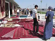
Altyn Asyr Bazaar in Choganly, also known as "Tolkuchka", features manufactured items including traditional fabrics and hand-woven carpets, as well as livestock and used automobiles. Modern shopping areas are found mostly in central streets, including the modern Berkarar Mall and the Paýtagt and Aşgabat shopping centres, as well as the 15 Years of Independence Shopping Centre (Turkmen: 15 ýyl Garaşsyzlyk söwda merkezi), colloquially known as the "Wholesale Market" (Russian: Optovyy rynok).[113][114][115]
Local residents tend to shop at traditional bazaars: Gülistan (Russian) Bazaar, Teke Bazaar, Daşoguz Bazaar, Paytagt (Mir) Bazaar, and Jennet Bazaar. The Turkish-owned Yimpaş department store closed as of December 2016.[116]
Transportation
.jpg.webp)
.jpg.webp)
The city is served by the Ashgabat International Airport, expansion of which cost $2.3 billion and which has a design capacity of 14,000,000 passengers per year.[117][118][119] Turkmenistan Airlines is headquartered at the airport.[120] Ashgabat offers air service to and from all the major cities of the Turkmenistan, as well as some destinations in Asia and Europe. Ashgabat is served by the following foreign airlines: Belavia, Turkish Airlines, S7 Airlines, flydubai, China Southern Airlines, cargolux.
The Trans-Caspian Railway (Turkmenbashy–Balkanabat–Bereket–Ashgabat–Mary–Türkmenabat) runs through Ashgabat from east to west. Since 2006 there is also a train line from Ashgabat to the north, the Trans-Karakum Railway.[121] In May 2009 the restoration of the Ashgabat railway station was completed.
The new International passenger Bus Terminal of Ashgabat was inaugurated on September 5, 2014.[122][123] It offers intercity service to Turkmenbashy, Dashoguz, Turkmenabat, Archman, Konye-Urgench, and Mollagara, as well as points in between.[124] The main intracity bus terminals serving Ashgabat are near the Teke Bazaar and at the domestic airport terminal.
Public transport in the city consists mainly of buses. More than 60 bus lines cover a total range of more than 2,230 kilometres (1,386 miles) with 700 buses running on urban routes. The city primarily uses Mercedes-Benz and Hyundai buses.[125] Bus timetables and detailed schematic map of the route are at every stop. Distances between stops are about 300–500 meters. From 19 October 1964 to 31 December 2011 the city also had the Ashgabat trolleybus system. At the beginning of the twentieth century a narrow-gauge steam railway connected the city with the suburb of Firyuza.
On 18 October 2006, the Ashgabat Cable Car opened, connecting the city with the foothills of the Kopetdag.[126]
Ashgabat Monorail commenced service in 2016, becoming the first monorail in the Central Asia region.[127] It circulates exclusively on the territory of the Olympic Village (Turkmen: Olimpiýa şäherçesi).
In January 2018, it was reported that black cars had been impounded for weeks in Ashgabat, a result of President Gurbanguly Berdimuhamedov's conviction that black cars bring bad luck.[128]
Science and education
Ashgabat is the most important educational center of Turkmenistan with several institutions of higher education. Magtymguly Turkmen State University was founded in 1950. The main university building is located on Beýik Saparmyrat Türkmenbaşy şaýoly. Turkmen State Medical University is situated in Ashgabat as well. It is subordinate to the Ministry of Health and Pharmaceutical Industry of Turkmenistan. Other prominent institutions are the Turkmen State Institute of Economics and Management, a main business school founded in 1980, as well as the Turkmen State Institute of Architecture and Construction, Turkmen Agricultural University, and The National Institute of Sports and Tourism of Turkmenistan. In 2016, the English- and Japanese-medium Oguzhan Engineering Technology University was opened with support of the Japanese government. The International University of Humanities and Development is another English-medium institution of higher education. The Ministry of Foreign Affairs' training ground is the Institute of International Relations.[129][130]
Ashgabat is home to five military academies: the Military Institute, the Naval Institute, the Border Guards Institute, the Institute of National Security, and the Ministry of Internal Affairs Institute. In 2020 the Military Institute began accepting applications from women.[130][131]
Four international secondary schools operate in Ashgabat. The Russian Embassy sponsors the Russian-medium A.S. Pushkin Russo-Turkmen School, the French construction company Bouygues sponsors a French school for children of its Francophone employees, the Turkish Embassy sponsors the Turkish-medium Turgut Ozal Turkmen-Turkish School, and the American Embassy sponsors the English-medium Ashgabat International School. [132][133][134][135]
Prior to establishment of Soviet authority in Turkmenistan, Ashgabat had only 11 schools and no scientific or research centers.[14] By 1948 Ashgabat had three institutions of higher education, 20 technical schools, 60 libraries, "and approximately the same number of kindergartens."[18]
The Turkmen Academy of Sciences was founded June 29, 1951, and includes the unique Desert Institute among its 26 scientific research institutes, as well as the State Seismological Service, 17-degree-granting schools, two medical research centers, a library, and two print shops. The Academy of Sciences is the only institution in Turkmenistan accredited to award postgraduate degrees. In 2019, President Berdimuhamedov decreed that state funding of the Academy of Sciences would end within three years.[14][136][137][138][139] Prior to founding of the Turkmen Academy of Sciences, local scientific-research institutes, all located in a single two-story building, were subordinate to the USSR Academy of Sciences.[18]
Main sights
.jpg.webp)
Museums include the Turkmen Fine Arts Museum and Turkmen Carpet Museum, noted for their impressive collection of woven carpets as well as a Turkmen history museum and the Ashgabat National Museum of History, which displays artifacts dating back to the Parthian and Persian civilizations. Ashgabat was also home to the Arch of Neutrality, a 75 m (250 ft) tall tripod crowned by a golden statue of late president Saparmurat Niyazov (also known as Turkmenbashy, or head Turkmen). The 15 m (50 ft) high statue, which rotated in order to always face the sun during daylight hours, was removed on August 26, 2010, after Niyazov's successor, current President Berdimuhamedov, made clear earlier in the year that the statue was to be taken out of Ashgabat's Independence Square.[140] In 2011 a Monument to the Constitution was built, its total height of 185 m (607 ft) makes it the second tallest structure in Turkmenistan.[141]
Alem Cultural and Entertainment Center was recognised by Guinness World Records as the world's tallest Ferris wheel in an enclosed space.[142] The Ashgabat Flagpole is the fourth tallest free-standing flagpole in the world, standing at 436 ft (133 m) tall. The Ashgabat Fountain has the world's greatest number of fountain pools in a public place.[143][144] Ashgabat also features Turkmenistan Tower which is the tallest tower in Turkmenistan, the decorative octagonal Star of Oguzkhan is recognized as the world's largest architectural image of the star and entered in the Guinness World Records.[145]
Palaces
- Oguzkhan Presidential Palace, the official presidential headquarters.
- Ruhyýet Palace, a place for official state events, forums, meetings, inaugurations.
- Wedding Palace, a civil registry building.[146]
Theatres
Ashgabat's major theaters are:
- Alp Arslan Turkmen National Theatre of Youth
- Magtymguly Musical and Drama Theater
- Main Drama Theatre
- Mollanepes Turkmen Drama Theater
- Mukam Palace
- Oil and Gas Cultural Commercial Center
- Pushkin State Russian Drama Theatre
- Shapak Cultural Center Turkmen: Şapak Medeniýet Merkezi
- Turkmen State Puppet Theater
- Turkmen State Circus
- Watan Theatre
Each of several former municipalities annexed by Ashgabat also features local a "house of culture" Turkmen: Medeniýet Öýi.
Parks and squares
Ashgabat has many parks and open spaces, mainly established in the early years of the Independence and well maintained and expanded thereafter. The most important of these parks are: the Botanical Garden, Güneş, Turkmen-Turkish friendship, Independence. The oldest city park, Ashgabat, was founded in 1887 and is colloquially known as First Park.[147] In the center of Ashgabat is the Inspiration Alley, an art-park complex which is a favorite place for many locals. The amusement park World of Turkmenbashi Tales is a local equivalent to Disneyland. Squares: 10 Years of Turkmenistan Independence, Magtymguly, Eternal Flame, Zelili, Chyrchyk, Garashsyzlyk, March 8, Gerogly, Dolphin, 15 years of Independence, Ruhyýet, 10 ýyl Abadançylyk.[148]
The Ashgabat Botanical Garden was founded on 1 October 1929, and is the oldest botanical garden in Central Asia.[149][150][151] It covers a territory of approximately 18 hectares, and contains a live exhibition of more than 500 different species of plants coming from various parts of the world.[152][153]
Halk Hakydasy Memorial Complex
Halk Hakydasy Memorial Complex was opened in 2014 in remembrance of those killed in the Battle of Geok Tepe in 1881, during World War II, and to commemorate of the victims of the 1948 Ashgabat earthquake. It is located in the southwestern part of the city on Bekrewe köçesi.[154][155]
Cinemas
Ashgabat has four cinemas. In 2011, Aşgabat Cinema, the first 3-D cinema in Turkmenistan, opened in Ashgabat.[156] The Watan and Turkmenistan theaters were reconstructed. Additional cinemas are located in the Berkarar Mall and the Gül zemin Mall.
Mosques
Major mosques in central Ashgabat include:
- Türkmenbaşy Ruhy Mosque
- Ärtogrul Gazy Mosque, a gift from Turkey, was inaugurated in 1998 and resembles the Blue Mosque in Istanbul.
- old Hezreti Omar Mosque in the 8th microdistrict
- new Hezreti Omar Mosque in the Parahat 7 microdistrict[157]
- Azadi Mosque on Zarpçi köçesi
- Shehitler (Turkmen: Şehitler) mosque on Görogly köçesi
- Iranian mosque near the Iranian Embassy
There are also several mosques in former towns and villages annexed by Ashgabat and thus now neighborhoods within the city limits.
Churches
Ashgabat has five operating Christian churches. Four are Russian Orthodox churches:[158]
- Saint Alexander Nevsky Church, founded in 1882 as parish church of the Russian military garrison, consecrated in 1900, located in the 30th Microdistrict (Russian: Храм святого благоверного великого князя Александра Невского)
- Temple of Saint Nicholas the Miracle-Worker, located inside the Khitrovka Cemetery (Russian: храм святителя и Чудотворца Николая)
- Temple of the Resurrection of Jesus Christ, located near the Ruhnama School (Russian: храм Воскресения Христова)
- Temple of the Holy Equals to Apostles Cyril and Methodius, located in Büzmeýin (Russian: Храм святых равноапостольных Кирилла и Мефодия)
The Roman Catholic Chapel of the Transfiguration operates on the grounds of the Apostolic nunciature.
Other Christian denominations exist but as of 2019 only two were registered with the government and thus able to operate legally. The U.S. Department of State reported that Turkmen authorities "scrutinize or obstruct religious groups attempting to purchase or lease buildings or land for religious purposes."[159]
Sports
The main sporting venues in Ashgabat are the Olympic Stadium, Ashgabat Stadium, the National Olympic ice rink, Sports complex for winter sports and the Olympic water sports complex.
Ashgabat was chosen as the host city of the V Asian Indoor and Martial Arts Games,[160] and was also the first city in Central Asia to host the Asian Indoor Games. Between 2010 and 2017 an Olympic Village was built by the Turkish firm Polimeks south of the city center, at a cost of $5 billion.[161][162]
In October 2017 a Jack Nicklaus Designs Signature 18-hole golf course opened in Ashgabat. It features 82 sand traps and covers 70 hectares.[163][164][165][166][167][168][169]
Ashgabat was the host of the 2018 IWF World Weightlifting Championships.
The city's professional football clubs Altyn Asyr FK, FC Aşgabat and FK Köpetdag Aşgabat play in the Ýokary Liga, the top league of Turkmenistan.
Inha Babakova, 1999 World High Jump champion, was born in Ashgabat.
See also
References
Notes
- "Türkmenistanyň Halk Maslahatynyň Çözgüdi HM-6 14 December 1992" (PDF).
- Türkmenistanyň Prezidentiniň Permanlary опубликованно 07.02.2020
- "Ashgabat | Definition of Ashgabat in English by Oxford Dictionaries". Oxford Dictionaries | English. Retrieved November 23, 2018.
- "Turkmenistan: Government Orders People Out Of Their Homes In Name Of 'Urban Renewal'". July 21, 2004. Retrieved November 22, 2017.
- Scott, Noel (October 28, 2010). Tourism in the Muslim World. Emerald Group Publishing. ISBN 978-1-84950-920-6.
- "Brief Note on Turkmenistan". Embassy of India, Ashgabat. Archived from the original on February 18, 2014. Retrieved June 10, 2014.
- Chapman, Wilson (June 18, 2019). "Ashgabat, Turkmenistan, Is the World's Most Expensive City for Expats". US News & World Report. Retrieved July 3, 2020.
- Williams, Ollie (June 8, 2020). "The 10 Most Expensive Cities in the World Just Became Pricier". Forbes. Retrieved July 3, 2020.
- Клычев, Анна-Мухамед (1976). Ашхабад (in Russian). Изд-во "Туркменистан".
- "How Old is Ashgabat?". Turkmeniya.tripod.com. Retrieved November 24, 2013.
- "Ashgabat, Turkmenistan". NASA. September 11, 2001.
- Ashgabat: Map of City Centre (Map). Ashgabat: Enterprise No. 5 of the Ministry of Defense. 2015.
- Ашхабад [Ashkhabad] (Map) (1969 ed.). 1:25,000. Генеральный штаб (in Russian). Генеральный штаб СССР. 1982. §§ J-40-69,70,81,82.
- Туркменская Советская Социалистическая Республика: Энциклопедический справочник (in Russian). Ashkhabad: Издательство Чувашского обкома КПСС. 1984.
- Михайлова, Н.Н., ed. (1948). "Туркменистан в образах литературы". Туркменистан. Наша Родина (in Russian). Moscow: Молодая гвардия.
- "Ашхабад: беломраморный город любви" (in Russian). Международное информационное агентство "Россия сегодня". December 17, 2015.
- Khramov, Viktor, ed. (2015). Guide-Book to Ashgabat. Ashgabat: Turkmen State Publishing Service.
- Скосырев, П. (1948). "Ашхабад--столица Советского Туркменистана". In Михайлова, Н.Н. (ed.). Туркменистан. Наша Родина (in Russian). Moscow: Молодая гвардия.
- Komarov, Vladimir (October 6, 2018). "Ашхабадская трагедия: 70 лет спустя". Туркменистан: золотой век (in Russian).
- Брегман, Михаил. "ЭТАПЫ ЖИЗНЕННОГО ПУТИ, Часть 6. ТУРКМЕНИЯ" (in Russian). "Partner" MedienHaus GmbH & Co. KG.
- ""Ашхабадская катастрофа". Глава из книги Б.Каррыева "Вот пришло землетрясение"" (in Russian). Infoabad. September 6, 2015.
- Komarov, Vladimir (November 9, 2013). "Столица, устремленная в будущее". Туркменистан: золотой век (in Russian).
- "Turkmen Leader Opens Gold Palace". Moscow Times. May 19, 2011.
- "Ashgabat". OpenStreetMap.
- Ашхабад J-40-081 (Map) (in Russian). Cartography by USSR Ministry of Defense.
- Схема территорий, предназначенных для включения в пределы города Aшхабада (Map) (in Russian). May 27, 2013.
- "Изменения в административной карте столицы Туркменистана и ее прилегающих территорий". Туркменистан: золотой век (in Russian). May 28, 2013.
- "Изменения в административной карте столицы Туркменистана и ее прилегающих территорий" (in Russian). Turkmeninform. May 28, 2013.
- Схема территорий этрапов города Ашхабада (Map) (in Russian). January 5, 2018.
- "Меджлис Туркменистана принял Постановление о вопросах административно-территориального деления города Ашхабада". Туркменистан: золотой век (in Russian). January 5, 2018.
- "Weather and Climate-The Climate of Ashgabat" (in Russian). Weather and Climate. Retrieved August 21, 2012.
- "Weather and Climate- The Climate of Ashgabat" (in Russian). Weather and Climate (Погода и климат). Archived from the original on December 26, 2018. Retrieved May 14, 2015.
- "Ashgabat Climate Normals 1961–1990". National Oceanic and Atmospheric Administration. Retrieved May 14, 2015.
- Konjikala Archived October 29, 2014, at the Wayback Machine
- Knowlton, MaryLee (2006). Turkmenistan. Marshall Cavendish. p. 40. ISBN 978-0-7614-2014-9.
- "На территории Ашхабада обнаружена керамика парфянской эпохи". Туркменистан: золотой век (in Russian). September 11, 2020.
- The Country of the Turkomans. London: Oguz Press and the Royal Geographical Society. 1977. ISBN 0-905820-01-0., Chapter 11, Stuart, Lt. Col. H.C., The Country of the Tekke Turkomans, and the Tejend and Murghab Rivers, lecture delivered in 1881.
- Pospelov, pp. 29–30
- Chisholm, Hugh, ed. (1911). . Encyclopædia Britannica. 2 (11th ed.). Cambridge University Press. p. 762.
- План города Асхабада [Plan goroda Askhabada] (Map). "100 sazhen to one English inch" (1:8,400) (in Russian). c. 1890.
- "Baha'i House of Worship in Ashgabat". Bahai.us. Archived from the original on August 8, 2007. Retrieved June 28, 2010.
- The Country of the Turkomans: An anthology of exploration from the Royal Geographic Society. Oguz Press and the Royal Geographic Society. 1977. ISBN 0-905820-01-0.
- "Ашхабад". Bse.sci-lib.com. May 28, 2009. Retrieved February 26, 2015.
- "State of the Map keynote, State of the Map 2016". October 4, 2016.
- "Gazetteer of Ashgabat Street Names". Open Street Map Wiki.
- "Comments for the significant earthquake". Significant Earthquake Database. National Geophysical Data Center. Retrieved June 12, 2015.
- "US Geological Survey". Earthquake.usgs.gov. Archived from the original on September 1, 2009. Retrieved June 28, 2010.
- Britannica Concise Encyclopedia. "Britannica Online". Britannica.com. Retrieved June 28, 2010.
- "Today the People of Turkmenistan Mourn for Those Perished in the 1948 Ashgabat Earthquake". Golden Age State News Agency. October 6, 2007. Archived from the original on April 6, 2009. Retrieved June 28, 2010.
- Ардаев, Владимир (October 6, 2003). "Би-би-си | Люди и нравы | Горькая память Ашхабада". BBC News (in Russian). Retrieved November 24, 2013.
- Ministry of Defense of Turkmenistan Enterprise No. 5 (2011). Ashgabat (Map). Cartography by Ministry of Defense. Ashgabat: Sofitel.
- "АШХАБАД ПЕРЕХОДИТ НА ЦИФРОВУЮ СИСТЕМУ ОБОЗНАЧЕНИЯ УЛИЦ" (in Russian). Turkmenistan.ru. May 6, 2002.
- "Turkmenistan enters record books for having the most white marble buildings | World news". theguardian.com. London. May 26, 2013. Retrieved November 24, 2013.
- "Этапы развития Туркменской столицы" (in Russian). Neytral'nyy Turkmenistan. November 12, 2020.
- "Этапы развития Туркменской столицы" (in Russian). Neytral'nyy Turkmenistan. November 13, 2020.
- "С расширенного заседания Кабинета Министров Туркменистана" (in Russian). Государственное информационное агентство Туркменистана (TDH) – Туркменистан сегодня. January 9, 2015.
- "В рамках 13-й очереди застройки Ашхабада введено в строй более 30 объектов" (in Russian). Infoabad. November 11, 2015.
- "Turkmenistan: Homeowners Evicted, Denied Compensation". Human Rights Watch. September 4, 2017.
- "Открывается 15 очередь застройки Ашхабада" (in Russian). SNG.TODAY. October 23, 2017.
- "В 15-ую очередь застройки Ашхабада войдет крупный комплекс 2-этажных коттеджей, десятки жилых домов" (in Russian). Turkmenportal. February 5, 2015.
- "Состоялось торжественное открытие зданий 14 очереди строительства Ашхабада" (in Russian). Turkmenportal. October 20, 2016.
- "В Ашхабаде начато строительство нового жилого микрорайона" (in Russian). SNG.TODAY. May 4, 2018.
- Komarov, Vladimir (May 3, 2018). "Началось возведение нового жилого комплекса вдоль проспекта Махтумкули". Туркменистан: золотой век (in Russian).
- "Президент Туркменистана открывает комплекс столичных новостроек" (in Russian). "Туркменистан: золотой век". November 10, 2020.
- "В новых жилых массивах туркменской столицы готовятся к сдаче дома, объекты социальной и транспортной инфраструктуры" (in Russian). Государственное информационное агентство Туркменистана (TDH) – Туркменистан сегодня. April 16, 2017.
- "Президент Туркменистана ознакомился с ходом реализации программы застройки Ашхабада". Туркменистан: золотой век (in Russian). September 4, 2018.
- Комаров, Владимир (February 18, 2019). "Началась реализация второй очереди застройки жилого массива Гуртлы". Туркменистан: золотой век (in Russian).
- "Проект "Ашхабад-сити" был представлен Президенту Туркменистана" (in Russian). Infoabad. June 21, 2019.
- ""Aşgabat – siti" 107 müň ýaşaýja niýetlenýär" (in Turkmen). Biznes Turkmenistan. June 21, 2019.
- "В сейсмоопасном Ашхабаде построят 35-этажный небоскреб" (in Russian). Chronicles of Turkmenistan. November 19, 2019.
- "Президенту Туркменистана показали грандиозный проект "Ашхабад-сити" (видео)" (in Russian). Chronicles of Turkmenistan. June 22, 2019.
- "Президент Гурбангулы Бердымухамедов ознакомился с масштабным градостроительным проектом" (in Russian). Туркменистан сегодня. June 20, 2019.
- Independent Neutral Turkmenistan: 10 Glorious Years of the Epoch of Turkmenbashi the Great, Ashgabat, 2001, pp. 39–40 (in Russian)
- "Постановление о вопросах административно-территориального деления города Ашхабада". January 5, 2018.
- "Глава государства подписал Постановления о переименовании и структурной реорганизации некоторых хякимликов Ахалского велаята и Ашхабада". January 5, 2018.
- "Меджлис Туркменистана внёс изменения в административно-территориальное деление города Ашхабада". January 5, 2018.
- "Парламент Туркменистана внёс изменения в административно-территориальное деление Ашхабада". January 6, 2018.
- "В Туркменистане изменились административные границы Ашхабада и Ахалского региона". January 6, 2018.
- "Глава государства подписал Постановления о переименовании и структурной реорганизации некоторых хякимликов Ахалского велаята и Ашхабада". January 8, 2018.
- "Ашхабад прирос новыми территориями". Государственное информационное агентство Туркменистана. May 27, 2013. Retrieved November 24, 2013.
- "Бердымухамедов открыл Золотое озеро – очередной грандиозный проект" (in Russian). Хроника Туркменистана. June 16, 2020.
- Chisholm, Hugh, ed. (1911). . Encyclopædia Britannica. 2 (11th ed.). Cambridge University Press. p. 762.
- Asgabat. "Национальный и религиозный состав населения Туркменистана сегодня". Archived from the original on June 24, 2016. Retrieved May 27, 2016.
- "French Bouygues to build new buildings for ministry of foreign affairs and ministry of education in Ashgabat". Turkmenistan.ru. October 29, 2008.
- "President of Turkmenistan inaugurates new residence – Palace Complex "Oguzkhan"". Turkmenistan.ru. May 19, 2011.
- "Third Palace Is A (Pricey) Charm For Turkmen President". RFE/RL. May 23, 2011.
- "Polimeks Construction With all its projects".
- "Gap Inşaat Completed Projects".
- Morton, Elise (November 2, 2016). "Architecture gone wild: the 12 most insanely great contemporary buildings of the New East". The Calvert Journal.
- Lomov, Anton (February 24, 2013). "Turkmenistan rebuilds capital into marble 'white city'". Daily Star (Lebanon)/Agence France Presse.
- "Звезда Огуз хана – в Книге рекордов Гиннесса". Туркменистан: золотой век (in Russian). October 30, 2011.
- "Туркмения. Часть I. Восьмиконечные звезды и гёли" (in Russian). Артемий Лебедев. May 31, 2014.
- Varlamov, Ilya (May 29, 2016). "Ashgabat, Turkmenistan". varlamov.ru.
- "Bicycle Monument Opened in Ashgabat on World Bicycle Day". Business Turkmenistan. June 3, 2020.
- "Turkmenistan leader unveils giant gold dog statue". BBC. November 12, 2020.
- "Turkmenistan: Open Letter to President Berdymukhadmedov regarding ongoing expropriation and demolition of homes in Ashgabat and the surrounding Akhal region". October 25, 2011.
- "Turkmenistan: Satellite images reveal how mass forced evictions blight upcoming Asian Games". Amnesty International. October 27, 2015.
- "Turkmenistan: Homeowners Evicted, Denied Compensation". Human Rights Watch. September 4, 2017.
- Najibullah, Farangis (April 21, 2007). "Turkmenistan: The Human Toll Of Ashgabat's Evictions". Eurasianet.
- "Turkmenistan: 2009 Country Reports on Human Rights Practices". U.S. Department of State. 2009.
- "2018 Country Reports on Human Rights Practices: Turkmenistan". U.S. Department of State. 2019.
- Smith, Peter (2000). "Mashriqu'l-Adhkhár". A concise encyclopedia of the Bahá'í Faith. Oxford: Oneworld Publications. p. 235. ISBN 1-85168-184-1.
- Rafati, V.; Sahba, F. (1989). "Bahai temples". Encyclopædia Iranica.
- Akiner, Shirin (1991). Kegan, Paul (ed.). Cultural Change and Continuity in Central Asia. Routledge. p. 293.
- "Baha'i House of Worship – Ashkabad, Central Asia". The National Spiritual Assembly of the Baha'is of the United States. 2007. Archived from the original on August 8, 2007. Retrieved August 3, 2007.
- Effendi, Shoghi (March 11, 1936). The World Order of Bahá'u'lláh. Haifa, Palestine: US Bahá’í Publishing Trust, 1991 first pocket-size edition. pp. 64–67.
- Комаров, Владимир. "Будущее беломраморной столицы". Электронная газета "Золотой век". Retrieved November 24, 2013.
- "Ashgabat Agreement". The Hans India. Retrieved August 2, 2017.
- Leung, Kanis (July 2, 2020). "Hong Kong falls two places to become sixth-most expensive city for expats". South China Morning Post. Retrieved July 3, 2020.
- "Expert: annual inflation rate in Turkmenistan reached almost 300%". Chronicles of Turkmenistan. June 6, 2018.
- "Ашхабад, Туркменистан". Retrieved March 12, 2015.
- Забродин, Федор. "Сделано в Туркменистане". Turkmenistan.ru. Retrieved March 12, 2015.
- Ashgabat Shopping Mall Archived October 5, 2013, at the Wayback Machine
- "Aşgabatdaky Söwda Merkezleri".
- "15 ýyl Garaşsyzlyk söwda merkezi".
- "The shopping centre Yimpas in Ashgabat dismisses staff before closing". Chronicles of Turkmenistan. December 12, 2016. Retrieved August 2, 2017.
- "Turkmenistan opens $2.3 billion bird-shaped international air terminal". Reuters. September 17, 2016.
- "Ashgabat International Airport, Turkmenistan 2016". Polimeks.
- "Ashgabat International Airport". CAPA Centre for Aviation. Aviation Week Network. Retrieved August 2, 2020.
- "Directory: World Airlines." Flight International. March 30–5 April 2004. .
- "Turkmenistan Railways" (in Turkmen and Russian). "Türkmendemirýollary" agentligi.
- "Turkmenistan to launch international bus service". Retrieved August 2, 2017.
- "В Ашхабаде будет построен пассажирский автовокзал международного класса | Интернет-газета" (in Russian). Turkmenistan.ru. Retrieved November 24, 2013.
- "International Bus Terminal of Ashgabat" (in Turkmen, Russian, and English).
- "Туркменистан: золотой век" (in Russian). Turkmenistan.gov.tm. January 28, 2013. Retrieved November 24, 2013.
- "Turkmen president attends inaugurations of three facilities dated to 15th anniversary of Turkmenistan". Turkmenistan.ru. Retrieved November 24, 2013.
- "'Bad Luck' For Black Car Owners in Turkmen Capital". Radio Free Europe/Radio Liberty. January 8, 2018.
- "Образование в Туркменистане" (in Russian). Brest State A.S. Pushkin University.
- "ОБРАЗОВАНИЕ" (in Russian). Turkmenportal.
- "Военный институт Туркменистана открыл прием на учебу для женщин" (in Russian). Turkmenportal. January 19, 2020.
- "СОВМЕСТНАЯ ТУРКМЕНО-РОССИЙСКАЯ СРЕДНЯЯ ОБЩЕОБРАЗОВАТЕЛЬНАЯ ШКОЛА ИМЕНИ А. С. ПУШКИНА" (in Russian). СТРСОШ имени А.С. Пушкина.
- "Ecole française Mlf Bouygues" (in French). Mission laïque française.
- "Türkmenistan Aşgabat Türk Anadolu Lisesi" (in Turkish). T.C. MİLLÎ EĞİTİM BAKANLIĞI.
- "ASHGABAT INTERNATIONAL SCHOOL". Quality Schools International.
- "Денег нет: конец туркменской науки?" (in Russian). Газета.Ru (Gazeta.Ru). February 11, 2019.
- "Turkmenistan to cut state funding for science". Washington Post/Associated Press. January 30, 2019. Archived from the original on January 31, 2019.
- "Будет изменена система финансирования Академии наук Туркменистана". Туркменистан: золотой век (in Russian). January 29, 2019.
- "Financing of the Academy of Sciences of Turkmenistan to be chnaged [sic]". state news agency of Turkmenistan – Turkmenistan today. January 29, 2019.
- "Niyazov's influence in Turkmenistan falls with golden statue". Centralasianewswire.com. Archived from the original on July 16, 2011. Retrieved November 24, 2013.
- The Monument Of The Constitution Archived October 29, 2013, at the Wayback Machine
- "Turkmenistan builds largest indoor Ferris wheel". May 24, 2012. Retrieved August 2, 2017.
- "Most fountain pools in a public place". Retrieved August 2, 2017.
- Ashgabat in Guinness book
- "Largest architectural star record set in Turkmenistan". November 14, 2011. Retrieved August 2, 2017.
- Weddenig palace Archived September 23, 2013, at the Wayback Machine
- "Monument-symbol of city and amusement park inaugurated in Ashgabat – Turkmenistan.ru". www.turkmenistan.ru. Retrieved August 2, 2017.
- "Parks, squares and entertainment centers". Ashgabat.gov.tm. Archived from the original on June 13, 2013. Retrieved November 24, 2013.
- Ашхабадскому ботсаду – 85 лет
- Ашхабадский ботанический сад старейший в регионе
- В Ашхабаде начали реконструировать Ботанический сад
- Ашхабадский ботанический сад: день вчерашний и завтрашний
- Ботанический сад в Ашхабаде будет реконструирован
- Посещение Мемориального комплекса «Народная память» Archived December 11, 2014, at the Wayback Machine
- "Президент Туркменистана принял участие в открытии мемориального комплекса и траурных мероприятиях Дня памяти – Интернет-газета Turkmenistan.Ru". www.turkmenistan.ru. Retrieved August 2, 2017.
- "Ashgabat residents get 3D cinema – Turkmenistan.ru". www.turkmenistan.ru. Retrieved August 2, 2017.
- ""Parahat – 7" ýaşaýyş toplumynda "Hezreti Omar" metjidiniň açylyş dabarasyndan fotoreportaž" (in Turkmen). Turkmenportal.com. September 30, 2018.
- "Православие в Туркменистане, Приходы" (in Russian). May 7, 2013.
- U.S. Department of State (May 2020). "TURKMENISTAN 2019 INTERNATIONAL RELIGIOUS FREEDOM REPORT" (PDF). U.S. Department of State.
- "Archived copy". Archived from the original on April 22, 2020. Retrieved April 28, 2020.CS1 maint: archived copy as title (link)
- Polimeks website, "Olympic Complex". Retrieved July 25, 2020.
- "$5 billion from the Treasury spent on the Olympic village in Ashgabat". Chronicles of Turkmenistan. December 8, 2016. Retrieved July 25, 2020.
- "Президент Гурбангулы Бердымухамедов посетил столичный гольф-клуб" (in Russian). Государственное информационное агентство Туркменистана (TDH) – Туркменистан сегодня. February 24, 2019.
- "Президент Туркменистана дал старт спортивной жизни Ашхабадского гольф-клуба" (in Russian). МИНИСТЕРСТВО СТРОИТЕЛЬСТВА И АРХИТЕКТУРЫ ТУРКМЕНИСТАНА. October 17, 2017.
- "Ашхабадский гольф-клуб – новое слово в развитии отечественной спортивной и рекреационной индустрии". Туркменистан: золотой век (in Russian). October 17, 2017.
- "Первый гольф-клуб в Туркменистане готовится принять гостей" (in Russian). ORIENT-ИНФОРМАЦИОННОЕ АГЕНТСТВО "МЕДИА-ТУРКМЕН". October 16, 2017.
- "Nicklaus designing course in ... Turkmenistan?". Golf Channel. December 14, 2016.
- "Let Them Play Golf: Destitute Turkmen Get Designer Golf Course". RFE/RL. October 21, 2017.
- "Jack Nicklaus Is Building His Newest Golf Course in Turkmenistan". EB GOLF MEDIA LLC. December 14, 2016.
- "Kostroma is looking for a twin city in Turkmenistan". orient.tm. Orient. July 15, 2020. Retrieved November 12, 2020.
- "State visit of President of Turkmenistan to the Republic of Kazakhstan". mfa.gov.tm. Ministry of Foreign Affairs of Turkmenistan. April 18, 2017. Retrieved November 12, 2020.
Sources
- Е. М. Поспелов (Ye. M. Pospelov). "Имена городов: вчера и сегодня (1917–1992). Топонимический словарь." (City Names: Yesterday and Today (1917–1992). Toponymic Dictionary.) Москва, "Русские словари", 1993.
External links
| Wikimedia Commons has media related to Aşgabat. |
| Wikivoyage has a travel guide for Ashgabat. |
- Official website
- Ashgabat Photo Gallery
- impressions of Ashgabat (in German)
- The city of white marble
- Ashgabat Photo Gallery. Pictures of modern Ashgabat.
- Page on modern Ashgabat (in Russian)
- Pre-1948 photo of Baha’i House of Worship in Ashgabat
- www.ashgabatairport.com – Ashgabat International Airport unofficial website (English)
- Tourism in Ashgabat
- Travel to Ashgabat from "Abassayoh"
Capital: Ashgabat | |