Bandipore district
Bandipore district (also spelt as Bandipora or Bandipur) is one of the 20 districts in the Indian union territory of Jammu and Kashmir. Bandipore town is the administrative headquarters of the district. Bandipore, a township with peculiar scenic beauty is located in the foothills of the snow-clad peaks of Harmukh overlooking the shores of Wular Lake has produced hundreds of scholars and intellectuals. Before 1947, this town was a big trade and literary centre of Kashmir. Bandipore, the birthplace of the great historian, Hassan Khoehami. This district was carved out from the erstwhile Baramulla district in 2007. The district is bounded by Kupwara district in the west, Baramulla district in the south and Kargil district in Ladakh, Srinagar and Ganderbal districts in the east. This district occupies an area of 398 km2.[2] The district has a population of 392,232 as per 2011 census.
Bandipore
Bandipora, Bandipur | |
|---|---|
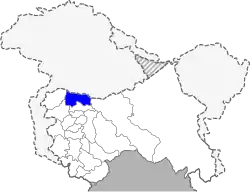 Location in Jammu and Kashmir, India | |
| Coordinates: 34°25′12″N 74°39′00″E | |
| Country | |
| Union Territory | Jammu and Kashmir |
| Division | Kashmir Division |
| Seat | Bandipore |
| Area | |
| • District of Jammu and Kashmir | 345 km2 (133 sq mi) |
| • Urban | 49.6 km2 (19.2 sq mi) |
| • Rural | 295.4 km2 (114.1 sq mi) |
| Population (2011)[1] | |
| • District of Jammu and Kashmir | 392,232 |
| • Density | 1,100/km2 (2,900/sq mi) |
| Time zone | Indian Standard Time |
| Website | bandipore |
Education
Some of the institutions and colleges of Bandipore Which provide quality education to the students of district Bandipore
- Govt Girls Higher Secondary School , Plan Bandipora
- Govt NM Boys Higher School Kaloosa
- Govt Polytechnic College
- Al-Noor College Of Education moder
- Mehboobul Aalam College Of Education
- Govt High School Bagh]
- Govt High School Qazipora bandipora
- Muslim Model School Qazipora Watapora
- Govt HKM Degree College
- Army Good Will School Aythmulla
- Shaheen College Of Education
- Govt Higher Sec. School Nadihal
- Govt Higher Sec. School Aloosa
- Govt Higher Sec. School Aragam
- Govt Secondary School Mantrigam
- Govt Secondary School Bonakoot
- Eaglets Public Secondary School Plan
- SMS Islamia Model Higher Secondary School, Garoora
Divisions
The district comprises seven tehsils: Ajas, Aloosa, Bandipore, Sumbal, Hajin, Gurez and Tulail. The district has three Vidhan Sabha constituencies: Gurez, Bandipore and Sonawari. All of these are part of Baramulla Lok Sabha constituency. The district comprises twelve community development blocks: Aloosa, Arin, Baktoor, Bandipore, Bonkoot, Ganastan, Gurez, Hajin, Naidkhai, Nowgam, Sumbal and Tulail.
Demographics
Bandipore district: mother-tongue of population, according to the 2011 Census.[4]
According to the 2011 census Bandipore district has a population of 392,232,[5] roughly equal to the nation of Maldives.[6] This gives it a ranking of 561st in India (out of a total of 640).[5] The district has a population density of 1,117 inhabitants per square kilometre (2,890/sq mi) .[5] Its population growth rate over the decade 2001–2011 was 26.31%.[5] Bandipore has a sex ratio of 899 females for every 1000 males[5] (this varies with religion), and a literacy rate of 57.82%.[5]
| Bandipore district: religion, gender ratio, and % urban of population, according to the 2011 Census.[3] | |||||||||
|---|---|---|---|---|---|---|---|---|---|
| Hindu | Muslim | Christian | Sikh | Buddhist | Jain | Other | Not stated | Total | |
| Total | 8,439 | 382,006 | 572 | 555 | 44 | 17 | 2 | 597 | 392,232 |
| 2.15% | 97.39% | 0.15% | 0.14% | 0.01% | 0.00% | 0.00% | 0.15% | 100.00% | |
| Male | 8,061 | 198,322 | 380 | 520 | 40 | 8 | 0 | 349 | 207,680 |
| Female | 378 | 183,684 | 192 | 35 | 4 | 9 | 2 | 248 | 184,552 |
| Gender ratio (% female) | 4.5% | 48.1% | 33.6% | 6.3% | 9.1% | 52.9% | 100.0% | 41.5% | 47.1% |
| Sex ratio (no. of females per 1,000 males) |
47 | 926 | 505 | 67 | – | – | – | 711 | 889 |
| Urban | 2,549 | 62,557 | 91 | 50 | 18 | 2 | 2 | 92 | 65,361 |
| Rural | 5,890 | 319,449 | 481 | 505 | 26 | 15 | 0 | 505 | 326,871 |
| % Urban | 30.2% | 16.4% | 15.9% | 9.0% | 40.9% | 11.8% | 100.0% | 15.4% | 16.7% |
Bandipore district
| |||
|---|---|---|---|
| Mother tongue code | Mother tongue | People | Percentage |
| 001002 | Assamese | 133 | 0.03% |
| 002007 | Bengali | 535 | 0.14% |
| 004001 | Dogri | 141 | 0.04% |
| 005018 | Gujarati | 118 | 0.03% |
| 006102 | Bhojpuri | 92 | 0.02% |
| 006195 | Garhwali | 43 | 0.01% |
| 006207 | Gojri/Gujjari/Gujar | 34,586 | 8.82% |
| 006235 | Haryanvi | 79 | 0.02% |
| 006240 | Hindi | 4,972 | 1.27% |
| 006340 | Kumauni | 44 | 0.01% |
| 006439 | Pahari | 7,478 | 1.91% |
| 006489 | Rajasthani | 96 | 0.02% |
| 006503 | Sadan/Sadri | 25 | 0.01% |
| 007016 | Kannada | 88 | 0.02% |
| 008005 | Kashmiri | 305,736 | 77.95% |
| 008019 | Dardi | 17,419 | 4.44% |
| 011016 | Malayalam | 155 | 0.04% |
| 013071 | Marathi | 922 | 0.24% |
| 014011 | Nepali | 573 | 0.15% |
| 015043 | Odia | 148 | 0.04% |
| 016038 | Punjabi | 620 | 0.16% |
| 020027 | Tamil | 109 | 0.03% |
| 021046 | Telugu | 141 | 0.04% |
| 022015 | Urdu | 315 | 0.08% |
| 029002 | Balti | 98 | 0.02% |
| 053005 | Gujari | 969 | 0.25% |
| 109005 | Shina | 16,407 | 4.18% |
| – | Others | 190 | 0.05% |
| Total | 392,232 | 100.00% | |
See also
References
- Census of India 2011
- Srivastava, Dayawanti et al (ed.) (2010). India 2010, A Reference Annual (PDF). New Delhi: Publications Division, Ministry of Information and Broadcasting, Government of Indiaand. p. 1142. ISBN 978-81-230-1617-7. Archived from the original (PDF) on 29 December 2010. Retrieved 21 January 2011.CS1 maint: extra text: authors list (link)
- C-1 Population By Religious Community – Jammu & Kashmir (Report). Office of the Registrar General & Census Commissioner, India. Retrieved 28 July 2020.
- C-16 Population By Mother Tongue – Jammu & Kashmir (Report). Office of the Registrar General & Census Commissioner, India. Retrieved 18 July 2020.
- "District Census 2011". Census2011.co.in. 2011. Retrieved 30 September 2011.
- US Directorate of Intelligence. "Country Comparison:Population". Retrieved 1 October 2011.
Maldives 394,999 July 2011 est.