Aybastı
Aybastı is a town and district of Ordu Province in the Black Sea region of Turkey. According to the 2000 census, population of the district is 31,071 of which 14,326 live in the town of Aybastı.[3][4] The district covers an area of 423 km2 (163 sq mi),[5] and the town lies at an elevation of 664 m (2,178 ft).
Aybastı | |
|---|---|
District | |
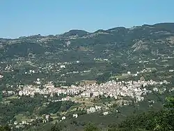 A panoramic view | |
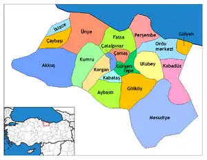 Location of Aybastı within Turkey. | |
 Aybastı Location of Aybastı | |
| Coordinates: 40°41′N 37°24′E | |
| Country | |
| Region | Black Sea |
| Province | Ordu |
| Government | |
| • Mayor | Beytullah Geçtan (AKP) |
| Area | |
| • District | 422.76 km2 (163.23 sq mi) |
| Elevation | 664 m (2,178 ft) |
| Population (2012)[2] | |
| • Urban | 13,885 |
| • District | 24,852 |
| • District density | 59/km2 (150/sq mi) |
| Time zone | UTC+2 (EET) |
| • Summer (DST) | UTC+3 (EEST) |
| Postal code | 52xxx |
| Area code(s) | 0452 |
| Licence plate | 52 |
| Climate | Csb |
| Website | www.aybasti.bel.tr |
Etymology
The town was formerly known as Ibasdi (variants include Ibasda and Ibassa, Ίβασσα in ancient Greek) and mutated to Aybastı in the 20th century.
Geography
Aybastı is a rural, agricultural district in the foothills of the Canik Mountains above the Black Sea coast, 54 km inland from the coastal town of Fatsa. The climate and flora are typical of the central Black Sea region although the district is drier at high altitudes. This is good agricultural land with 192 km2 (74 sq mi) of meadow and 116 km2 (45 sq mi) of farmland. The road up here from the coast is slow and winding, the journey takes over an hour, and journey from here up into the mountains is even worse, some of it on dirt roads. The people of these country villages are very traditional, for example they marry between the ages of 15 and 22 by arrangement between the families.
Aybastı itself is a small town providing high schools, a hospital and other basic amenities to the surrounding area. Market day is Saturday. The town is growing and today most buildings are four stories or more, the local economy is boosted by money coming from families that since the 1960s have been living and working in Istanbul, Ankara or abroad (especially France and Austria).
Places of interest
- Perşembe Plateau (Turkish: Perşembe Yaylası) is a high meadow, one of the biggest tourist attractions in the area, located 17 km from the town of Aybastı. Under snow in winter but popular with walkers and trekkers in summer, when there are folklore festivals and country fairs in the 3rd week of July.
Perşembe Plateau has one of the best example of meander in Turkey even its picture is already taken place at geography textbooks.
Notes
- "Area of regions (including lakes), km²". Regional Statistics Database. Turkish Statistical Institute. 2002. Retrieved 5 March 2013.
- "Population of province/district centers and towns/villages by districts - 2012". Address Based Population Registration System (ABPRS) Database. Turkish Statistical Institute. Retrieved 27 February 2013.
- Turkish Statistical Institute. "Census 2000, Key statistics for urban areas of Turkey" (in Turkish). Archived from the original (XLS) on 22 July 2007. Retrieved 4 May 2009.
- GeoHive. "Statistical information on Turkey's administrative units". Retrieved 4 May 2009.
- Statoids. "Statistical information on districts of Turkey". Archived from the original on 19 May 2009. Retrieved 4 May 2009.
References
- Falling Rain Genomics, Inc. "Geographical information on Aybastı, Turkey". Retrieved 3 May 2009.
External links
- (in Turkish) District governor's official website
- (in Turkish) Aybastı municipality
- (in Turkish) local info website (follow "resimler" for more photos)
- (in Turkish) and another one
- Road map of Aybastı and environs
- Various images of Aybastı, Ordu
- Epasa - Έπασα - Aybasti
Aybastı in Ordu Province of Turkey | |||||||||||||||||||||||||||
|---|---|---|---|---|---|---|---|---|---|---|---|---|---|---|---|---|---|---|---|---|---|---|---|---|---|---|---|
| Districts | Districts of Ordu | ||||||||||||||||||||||||||
| |||||||||||||||||||||||||||
Metropolitan municipalities are bolded. | |||||||||||||||||||||||||||