Gülyalı
Gülyalı, formerly Abulhayır, is a town and district of Ordu Province in the Black Sea region of Turkey, 15 km east of the city of Ordu, towards Giresun. According to the 2000 census, population of the district is 10,566 of which 5,245 live in the town of Gülyalı.[3][4] The district covers an area of 73 km2 (28 sq mi),[5] and the town lies at an elevation of 0 m (0 ft).
Gülyalı | |
|---|---|
District | |
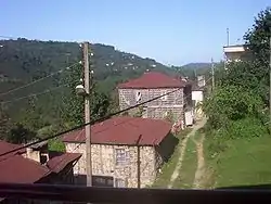 Kestane, a village in Gülyalı district | |
 Location of Gülyalı within Turkey. | |
 Gülyalı Location of Gülyalı | |
| Coordinates: 40°58′N 38°04′E | |
| Country | |
| Region | Black Sea |
| Province | Ordu |
| Government | |
| • Mayor | Talip Şen (AKP) |
| Area | |
| • District | 73.36 km2 (28.32 sq mi) |
| Elevation | 0 m (0 ft) |
| Population (2012)[2] | |
| • Urban | 3,383 |
| • District | 7,957 |
| • District density | 110/km2 (280/sq mi) |
| Time zone | UTC+2 (EET) |
| • Summer (DST) | UTC+3 (EEST) |
| Postal code | 52xxx |
| Area code(s) | 0452 |
| Licence plate | 52 |
| Climate | Cfa |
| Website | www.gulyali-bld.gov.tr |
The villages of Gülyalı district include Yeniköy, Ambarcılı, Ayrılık, Kestane, Mustafalı, Taşlıçay, and Turnasuyu.
Notes
- "Area of regions (including lakes), km²". Regional Statistics Database. Turkish Statistical Institute. 2002. Retrieved 2013-03-05.
- "Population of province/district centers and towns/villages by districts - 2012". Address Based Population Registration System (ABPRS) Database. Turkish Statistical Institute. Retrieved 2013-02-27.
- Turkish Statistical Institute. "Census 2000, Key statistics for urban areas of Turkey" (XLS) (in Turkish). Retrieved 2009-04-29.
- GeoHive. "Statistical information on Turkey's administrative units". Retrieved 2009-04-29.
- Statoids. "Statistical information on districts of Turkey". Retrieved 2009-04-29.
References
- Falling Rain Genomics, Inc. "Geographical information on Gülyalı, Turkey". Retrieved 2009-04-28.
External links
- District governor's official website (in Turkish)
- Road map of Gülyalı and environs
- Various images of Gülyalı, Ordu
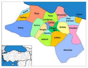
Gülyalı in Ordu Province of Turkey | |||||||||||||||||||||||||||
|---|---|---|---|---|---|---|---|---|---|---|---|---|---|---|---|---|---|---|---|---|---|---|---|---|---|---|---|
| Districts | Districts of Ordu | ||||||||||||||||||||||||||
| |||||||||||||||||||||||||||
Metropolitan municipalities are bolded. | |||||||||||||||||||||||||||
This article is issued from Wikipedia. The text is licensed under Creative Commons - Attribution - Sharealike. Additional terms may apply for the media files.