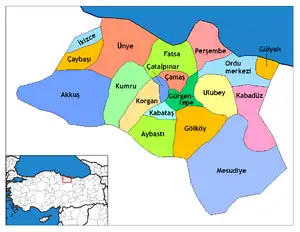
Korgan
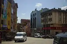
Korgan is a town and district of Ordu Province in the Black Sea region of Turkey. According to the 2000 census, the population of the district is 41,628 of which 15,587 live in the town of Korgan.[3][4] The district covers an area of 233 km2 (90 sq mi),[5] and the town lies at an elevation of 673 m (2,208 ft).
Korgan | |
|---|---|
District | |
 Location of Korgan within Turkey. | |
 Korgan Location of Korgan | |
| Coordinates: 40°49′N 37°21′E | |
| Country | |
| Region | Black Sea |
| Province | Ordu |
| Government | |
| • Mayor | Tuncay Kiraz (AKP) |
| Area | |
| • District | 233.38 km2 (90.11 sq mi) |
| Elevation | 673 m (2,208 ft) |
| Population (2012)[2] | |
| • Urban | 12,814 |
| • District | 33,000 |
| • District density | 140/km2 (370/sq mi) |
| Time zone | UTC+2 (EET) |
| • Summer (DST) | UTC+3 (EEST) |
| Postal code | 52700 |
| Area code(s) | 0452 |
| Licence plate | 52 |
| Climate | Csb |
| Website | www.korgan.bel.tr |
The villages of Korgan district include Aşağıkozpınar, Belalan, Beypınarı, Büyükakçakese, Çitlice, Durali, Karakışla, Koççığaz, Soğukpınar, Tatarcık, Tepeköy, Terzili, Yeniköy, Yeşilalan, Yeşildere, Yeşilyurt, and Yukarıkozpınar.
History
The district of Korgan has been a source of iron ore since the reign of Mithridates, King of Pontus, and even before that the area was occupied by Persians in the reign of Darius I in the 6th century BC, as part of the Satrapy of Pontus and Cappadocia. The Persian presence was erased by the armies of Alexander the Great in 331BC, and the area eventually became part of the Kingdom of Pontus and then the Roman Empire. This era ended in 1083 when Korgan was conquered by the Turkish armies of Danishmend Gazi. Subsequently a number of Turkish tribes ruled here until 1398 when Bayezid I brought the area, then known as Keşdere after a tributary of the River Bolaman, into the Ottoman Empire.
Notes
- "Area of regions (including lakes), km²". Regional Statistics Database. Turkish Statistical Institute. 2002. Retrieved 2013-03-05.
- "Population of province/district centers and towns/villages by districts - 2012". Address Based Population Registration System (ABPRS) Database. Turkish Statistical Institute. Retrieved 2013-02-27.
- Turkish Statistical Institute. "Census 2000, Key statistics for urban areas of Turkey" (in Turkish). Archived from the original (XLS) on 2007-09-27. Retrieved 2009-05-05.
- GeoHive. "Statistical information on Turkey's administrative units". Archived from the original on 2009-10-15. Retrieved 2009-05-05.
- Statoids. "Statistical information on districts of Turkey". Retrieved 2009-05-05.
References
- Falling Rain Genomics, Inc. "Geographical information on Korgan, Turkey". Retrieved 2009-05-05.
External links
| Wikimedia Commons has media related to Korgan. |
- District municipality's official website (in Turkish)
- Road map of Korgan and environs
- Various images of Korgan, Ordu
- Korgan Dünü ve Bugünü