Beresford Parish, New Brunswick
Beresford is a civil parish in Gloucester County, New Brunswick, Canada.[2]
Beresford | |
|---|---|
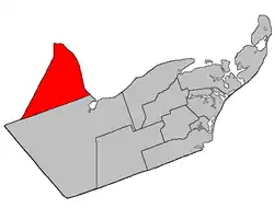 Location within Gloucester County, New Brunswick | |
| Coordinates: 47.715°N 65.8875°W | |
| Country | |
| Province | |
| County | Gloucester |
| Erected | 1814 |
| Area | |
| • Land | 456.86 km2 (176.39 sq mi) |
| Population (2016)[1] | |
| • Total | 6,248 |
| • Density | 13.7/km2 (35/sq mi) |
| • Change 2011-2016 | |
| • Dwellings | 2,780 |
| Time zone | UTC-4 (AST) |
| • Summer (DST) | UTC-3 (ADT) |
For governance purposes it is divided between the town of Beresford; the villages of Belledune, Nigadoo, Petit-Rocher, and Pointe-Verte; and the local service districts of Dunlop, Laplante,[lower-alpha 1] Madran, Petit-Rocher-Nord (Devereaux), Petit-Rocher-Sud, Robertville, Tremblay, and the parish of Beresford (which in turn includes the special service areas of Alcida and Dauversière; Nicholas-Denys, Free Grant and Sainte-Rosette; Petit Rocher West[lower-alpha 2]; Saint-Laurent Nord; Sainte-Louise; Sainte-Thérèse Sud; and Sormany),[lower-alpha 3] all of which are members of the Chaleur Regional Service Commission (CRSC).[4]
Origin of name
The parish was named for Baron Beresford, Commander in Chief of the Portuguese Army during the Peninsular War.[5] Six of the parishes erected simultaneously in Northumberland County in 1814[6] were named for prominent British military figures.
History
Beresford was erected in 1814 from unassigned lands,[6] including much of modern Restigouche County.
In 1827 Addington and Eldon Parishes were erected from land west of Benjamin River.[7]
In 1838 Restigouche County was erected, with the new county line running through Beresford Parish.[8]
In 1840 the Restigouche portion of Beresford was erected into Colborne and Durham Parishes.[9]
In 1881 the county line was adjusted, adding an inland part of Durham Parish to Beresford.[10]
Delineation
Beresford Parish is defined in the Territorial Division Act[2] as being bounded:
- West by the County line; east by the Chaleur Bay and south by the easterly prolongation of the south line of Restigouche County.
Communities
Parish population total does not include incorporated municipalities (in bold):
|
|
|
Demographics
Population
| Canada census – Beresford Parish, New Brunswick community profile | |||
|---|---|---|---|
| 2016 | 2011 | 2006 | |
| Population: | 6,248 (-1.7% from 2011) | 6,354 (+0.8% from 2006) | 6,301 (-4.8% from 2001) |
| Land area: | 456.86 km2 (176.39 sq mi) | 456.75 km2 (176.35 sq mi) | 455.93 km2 (176.04 sq mi) |
| Population density: | 13.7/km2 (35/sq mi) | 13.9/km2 (36/sq mi) | 13.8/km2 (36/sq mi) |
| Median age: | 49.1 (M: 49.2, F: 48.9) | 46.0 (M: 46.1, F: 46.0) | 42.4 (M: 42.6, F: 42.2) |
| Total private dwellings: | 2,780 | 2,730 | 2,633 |
| Median household income: | $57,968 | $53,109 | $45,901 |
| References: 2016[11] 2011[12] 2006[13] earlier[14] | |||
|
|
| |||||||||||||||||||||||||||
| [15][1] | |||||||||||||||||||||||||||||
Language
| Canada Census Mother Tongue - Beresford Parish, New Brunswick[15] | ||||||||||||||||||
|---|---|---|---|---|---|---|---|---|---|---|---|---|---|---|---|---|---|---|
| Census | Total | French |
English |
French & English |
Other | |||||||||||||
| Year | Responses | Count | Trend | Pop % | Count | Trend | Pop % | Count | Trend | Pop % | Count | Trend | Pop % | |||||
2011 |
6,275 |
5,755 | 91.71% | 435 | 6.93% | 60 | 0.96% | 25 | 0.40% | |||||||||
2006 |
6,205 |
5,575 | 89.85% | 475 | 7.65% | 95 | 1.53% | 60 | 0.97% | |||||||||
2001 |
6,520 |
5,925 | 90.87% | 500 | 7.67% | 75 | 1.15% | 20 | 0.31% | |||||||||
1996 |
6,785 |
6,155 | n/a | 90.71% | 570 | n/a | 8.40% | 50 | n/a | 0.74% | 10 | n/a | 0.15% | |||||
Access Routes
Highways and numbered routes that run through the parish, including external routes that start or finish at the parish limits:[16]
See also
Notes
- The LSD's name does not use an uppercase P.
- More commonly known by its French form Petit-Rocher-Ouest.
- The Taxing Authorities of the parish of Beresford LSD are Beresford (Alcida & Dauversière), Beresford (Nicholas-Denys), Beresford (Nord), Beresford (Petit Rocher West), Beresford (Saint-Laurent), and Beresford (Sud).[3]
References
- "Census Profile, 2016 Census: Beresford, Parish [Census subdivision], New Brunswick". Statistics Canada. Retrieved September 9, 2019.
- "Chapter T-3 Territorial Division Act". Government of New Brunswick. Retrieved 13 November 2020.
- "2019 Local Government Statistics for New Brunswick" (PDF). Department of Environment and Local Government. p. 59. Retrieved 8 July 2020.
- "Communities in each of the 12 Regional Service Commissions (RSC) / Les communautés dans chacune des 12 Commissions de services régionaux (CSR)" (PDF), Government of New Brunswick, July 2017, retrieved 2 February 2021
- Ganong, William F. (1896). A Monograph of the Place-Nomenclature of the Province of New Brunswick. Royal Society of Canada. p. 221.
- "54 Geo. III c. 17 An Act in further addition to an Act, intituled "An Act for the better ascertaining and confirming the boundaries of the several Counties, within this Province, and for subdividing them into Towns or Parishes."". Acts of the General Assembly of His Majesty's Province of New-Brunswick; Passed in the Year 1814. Saint John, New Brunswick: Government of New Brunswick. 1814. pp. 16–18.
- "7 Geo. IV c. 31 An Act for the division of the County of Northumberland into three Counties, and to provide for the Government and Representation of the two new Counties.". Acts of the General Assembly of His Majesty's Province of New-Brunswick, Passed in the Year 1827. Fredericton: Government of New Brunswick. 1827. pp. 97–103.
- "7 Wm. IV c. 57 An Act to erect part of the County of Gloucester into a separate and distinct County.". Acts of the General Assembly of Her Majesty's Province of New Brunswick, Passed in the Year 1838. Fredericton: Government of New Brunswick. 1838. pp. 94–95.
- "2 Vic. c. 19 An Act to divide the County of Restigouche into five Towns or Parishes and to define the boundaries thereof.". Acts of the General Assembly of Her Majesty's Province of New Brunswick, Passed in the Year 1839. Fredericton: Government of New Brunswick. 1839. pp. 63–64.
- "44 Vic. c. 24 An Act to amend Chapter 2 of The Consolidated Statutes, of 'The Division of the Province into Counties, Towns, and Parishes,' so far as the same relates to the Boundary between Restigouche and Gloucester.". Acts of the General Assembly of Her Majesty's Province of New Brunswick. Passed in the Month of March 1881. Fredericton: Government of New Brunswick. 1881. p. 57.
- "2016 Community Profiles". 2016 Canadian Census. Statistics Canada. February 21, 2017. Retrieved 2019-09-09.
- "2011 Community Profiles". 2011 Canadian Census. Statistics Canada. July 5, 2013. Retrieved 2014-03-30.
- "2006 Community Profiles". 2006 Canadian Census. Statistics Canada. March 30, 2011. Retrieved 2014-03-30.
- "2001 Community Profiles". 2001 Canadian Census. Statistics Canada. February 17, 2012.
- Statistics Canada: 1996, 2001, 2006, 2011 census
- Atlantic Canada Back Road Atlas ISBN 978-1-55368-618-7 Page 7
Places adjacent to Beresford Parish, New Brunswick | ||||||||||
|---|---|---|---|---|---|---|---|---|---|---|
| ||||||||||
| Subdivisions | |
|---|---|
| Cities | |
| Counties | |
| |