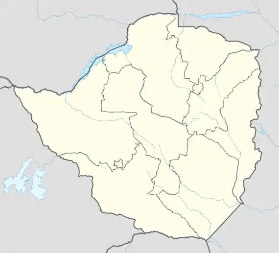
Beitbridge
Beitbridge is a border town in the province of Matabeleland South, Zimbabwe. The name also refers to the border post and bridge spanning the River Limpopo, which forms the political border between South Africa and Zimbabwe.
Beitbridge | |
|---|---|
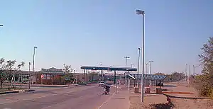 Beitbridge Borderpost, Zimbabwe | |
 Seal | |
 Beitbridge  Beitbridge | |
| Coordinates: 22°13′S 30°00′E | |
| Country | |
| Province | Matabeleland South |
| District | Beitbridge |
| Established | 1929 |
| Elevation | 457 m (1,499 ft) |
| Population (2012 census) | |
| • Total | 41,767 |
| Time zone | UTC+2 (CAT) |
| Climate | BSh |
Background
The town lies just north of the River Limpopo about 1 km from the Alfred Beit Road Bridge which spans the River Limpopo between South Africa and Zimbabwe. The main roads are the A6 highway to Bulawayo and the Victoria Falls, being 321 kilometres (199 mi) and 758 kilometres (471 mi) away respectively and the A4 to Masvingo and Harare. According to the 2002 population census, the town had a population of 22,387 dominated by the Venda and Ndebele people of this region. There is a small percentage of other people from other provinces because this is a busy border post with traders from all over Zimbabwe. The Beitbridge border post is the busiest road border post in Southern Africa, and is best avoided during busy border-crossing seasons.
Climate
| Climate data for Beitbridge (1961–1990) | |||||||||||||
|---|---|---|---|---|---|---|---|---|---|---|---|---|---|
| Month | Jan | Feb | Mar | Apr | May | Jun | Jul | Aug | Sep | Oct | Nov | Dec | Year |
| Record high °C (°F) | 43.3 (109.9) |
42.3 (108.1) |
42.2 (108.0) |
38.9 (102.0) |
36.7 (98.1) |
34.4 (93.9) |
33.9 (93.0) |
38.9 (102.0) |
40.0 (104.0) |
43.3 (109.9) |
44.4 (111.9) |
42.8 (109.0) |
44.4 (111.9) |
| Average high °C (°F) | 33.5 (92.3) |
32.8 (91.0) |
32.0 (89.6) |
30.4 (86.7) |
28.2 (82.8) |
25.4 (77.7) |
25.4 (77.7) |
27.6 (81.7) |
30.2 (86.4) |
31.8 (89.2) |
31.8 (89.2) |
33.1 (91.6) |
30.2 (86.4) |
| Average low °C (°F) | 21.9 (71.4) |
21.5 (70.7) |
20.1 (68.2) |
17.0 (62.6) |
11.9 (53.4) |
8.2 (46.8) |
7.9 (46.2) |
10.7 (51.3) |
15.2 (59.4) |
18.6 (65.5) |
20.3 (68.5) |
21.2 (70.2) |
16.2 (61.2) |
| Record low °C (°F) | 12.8 (55.0) |
14.4 (57.9) |
11.7 (53.1) |
3.9 (39.0) |
2.8 (37.0) |
−1.1 (30.0) |
−0.6 (30.9) |
0.0 (32.0) |
4.4 (39.9) |
8.9 (48.0) |
11.1 (52.0) |
13.3 (55.9) |
−1.1 (30.0) |
| Average rainfall mm (inches) | 56.8 (2.24) |
54.8 (2.16) |
34.1 (1.34) |
25.6 (1.01) |
10.0 (0.39) |
3.1 (0.12) |
0.4 (0.02) |
1.5 (0.06) |
14.9 (0.59) |
28.4 (1.12) |
48.7 (1.92) |
53.7 (2.11) |
332.0 (13.07) |
| Average rainy days | 5 | 4 | 3 | 2 | 1 | 1 | 0 | 0 | 1 | 2 | 5 | 5 | 29 |
| Average relative humidity (%) | 62 | 64 | 60 | 58 | 52 | 56 | 51 | 46 | 46 | 48 | 53 | 57 | 54 |
| Mean monthly sunshine hours | 244.9 | 217.5 | 241.8 | 240.0 | 275.9 | 252.0 | 263.5 | 272.8 | 252.0 | 248.0 | 225.0 | 226.3 | 2,959.7 |
| Mean daily sunshine hours | 7.9 | 7.7 | 7.8 | 8.0 | 8.9 | 8.4 | 8.5 | 8.8 | 8.4 | 8.0 | 7.5 | 7.3 | 8.1 |
| Source 1: World Meteorological Organization[1] | |||||||||||||
| Source 2: Deutscher Wetterdienst (extremes, humidity, and sun)[2] | |||||||||||||
The Town
Beitbridge has an estimated 2,570 houses in formal settlements (primarily for government officials and mid-level private sector staff) and 3,000 in informal settlements. Formal-settlement dwellings are mainly two- to three-room brick houses, while those in the informal settlements are among the worst mud houses in Zimbabwe. The mud houses have since been demolished. Average house occupancy in the low-income and informal settlements varies considerably, as many people do not bring their families to Beitbridge, but includes at least four people. Recreational facilities are limited in low-income areas, consisting largely of bars and soccer pitches.
Labour
The major sources of local employment—freight, retail, construction, customs and the police—employ about 1,200 people. Informal sector activities—primarily vending and sex work—are as large as those in the formal sector, employing about 1,400. Outside Beitbridge town, farming is a major employer. A diamond mine recently closed, increasing unemployment and poverty. Most women rely on vending, sex work and cross-border trading for income. Truckers are present in the area with work coming from the border area of South Africa.
The Bridge
The Alfred Beit Road Bridge is named after Alfred Beit, founder of the De Beers diamond mining company and business associate of Cecil Rhodes. He was also a director of a number of companies, among them the British South Africa Company and Rhodesia Railways. The original bridge was constructed in 1929 at a cost of $600,000 and financed jointly between the Beit Railways Trust and the South African Railways.[3] The new bridge was completed in 1995, and was officially opened on 24 November. It was built by the Zimbabwean Government, which now benefits from the tolls levied on crossings. The new bridge can accommodate much heavier traffic than the old one could, which is now for rail traffic only.
Development

On the South African side of the border the N1 Highway connects this border post to the main economic centres of Pretoria (463 km) and Johannesburg (521 km). The closest town is Musina (16 km). On the Zimbabwean side of the border post the road splits in two, with the A6 running to Bulawayo and the R1 to Masvingo. A railway also passes through this border post, side by side with the road, and splits into a line to Bulawayo and a line to Gweru via Rutenga.
Three railway lines meet at Beitbridge: the South African Spoornet line to Polokwane, the National Railways of Zimbabwe line to Gweru via Rutenga and the Beitbridge Bulawayo Railway.
Venue
Dulivhadzimu Stadium, a small multi-purpose arena in the town was chosen by the ZANU-PF led 21st February Movement to host the annual national celebration of Robert Mugabe's date of birth on Saturday, 23 February 2008. On 21 February, two days before, Mugabe had turned 84.[4] It was reported that workers repaired the potholes on the main roads in the city to make sure Mugabe's motorcade moved swiftly with a measure of comfort.
See also
References
- "World Weather Information Service – Beitbridge". World Meteorological Organization. Retrieved 12 May 2016.
- "Klimatafel von Beitbridge / Simbabwe" (PDF). Baseline climate means (1961-1990) from stations all over the world (in German). Deutscher Wetterdienst. Retrieved 12 May 2016.
- New Alfred Beit Bridge is opened The Montreal Gazette, 2 September 1929
- Beitbridge readies of Mugabe Archived 28 February 2008 at the Wayback Machine (accessed 20 February 2008)
External links
- Covid-19 poser as trucks overwhelm Beitbridge Border Post As of June 12 2020.
| Authority control |
|
|---|
Capital: Beitbridge | |
| Wards | |
| Rivers | |
| Dams/reservoirs |
|
| Landforms |
|
| Settlements |
|
| Transport | |
| Protected areas | |
| Education |
|
| Culture and sport |
|
| Notable people | |
| Constituencies |
|
