Bethel Island, California
Bethel Island (formerly known as Bethell, Bethell Ranch, Bethel Tract, Sand Mound Ranch, Sand Mound Tract) is a census-designated place (CDP) on Bethel Island in Contra Costa County, California, United States. The population was 2,137 at the 2010 census. The community of Bethel Island is governed as a Special Act District created by the California State legislature and named the Bethel Island Municipal Improvement District (BIMID). It is a popular destination for recreation seekers, especially hunters, fishermen and boaters.
Bethel Island | |
|---|---|
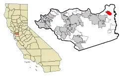 Location in Contra Costa County and the state of California | |
 Bethel Island Location in the United States | |
| Coordinates: 38°00′54″N 121°38′26″W | |
| Country | |
| State | |
| County | Contra Costa |
| Government | |
| • Type | Special act district |
| • State Senator | Steve Glazer (D)[1] |
| • State Assembly | Jim Frazier (D)[2] |
| • U. S. Congress | Jerry McNerney (D)[3] |
| Area | |
| • Total | 5.60 sq mi (14.50 km2) |
| • Land | 5.60 sq mi (14.50 km2) |
| • Water | 0.00 sq mi (0.00 km2) 0% |
| Elevation | −7 to −15 ft (−2 m) |
| Population (2010) | |
| • Total | 2,137 |
| • Estimate (2016)[5] | N/A |
| Time zone | UTC-8 (PST) |
| • Summer (DST) | UTC-7 (PDT) |
| ZIP code | 94511 |
| Area code(s) | 925 |
| FIPS code | 06-06210 |
| GNIS feature IDs | 1658045, 2407834 |
History
The landform known as Bethel Island was created between 1859 and 1870 by several men, see the names and survey numbers below. (Source: California State Archives for Land Patent Certificate of Purchase for Swamp and Overflow Surveys Numbers 80, 81, 82, 83, 225, 226, 227 and 250). Alonzo Stone purchased much of the property formerly owned by Warren and Anne Bethell, and the area was briefly referred to as the "Stone Tract" in the 1930s. Prior to this, it was referred to as "Sandmound Ranch", "Sandmound Tract" or "Bethel Tract" and contained an estimated area of 6,000 acres (24 km2), and did not become an island until 1911, when Dutch Slough was dredged eastward to join with Sandmound Slough. East Contra Costa Historical Society has been made aware of these inaccuracies, however has not yet updated their website.[6]
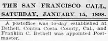
The first post office opened in 1898, and named for its first postmaster Franklin Cloud Bethell. The second "L" was dropped by a rather pious postal commissioner that reportedly felt it would be ungodly to allow the new location to be called "Bet Hell", and took liberties to change it to "Bethel" (בית אל), meaning "House of God" in Hebrew.[7] The post office closed in 1902.[7] A Post Office re-opened on Bethel Island in 1947.
Though it was common for the era to name the post office after the postmaster, and for the communities to assume the name of the post office, there are some references to the area as "Bethell" referring to the Sand Mound Ranch farm established by a coalition led by Franklin's older brother, Warren King Bethell, Nicholas Harris (Sheriff of San Jose) and James C. Smith. Prior "owners" of these lands were considered "land speculators" and only performed the minimum amount of improvements to reclaim the land in order to secure land patents. This may not be a fair assessment of all, since some did make an honest attempt to reclaim the lands only to be forced out by changes in governmental policy and financial constraints.
Actual "ownership" of the lands was accomplished through a long process of applications, surveys, improvements and Patents, as defined by the frequently amended Swamp and Overflow Lands Act. The first applications for land patents for what is now Bethel Island, Jersey Island, Franks Tract and Webb Tract, were secured by early California pioneers (the patent number precedes the name, and the date of application follows): 80-H. L. Henderon (1859), 81-Jabez Hatch (1859), 82-Elijah Hook (1859), 83-Stephen C. Vaughn (1859), 221-Edward P. Paine (1865), 222-John F. Arnold (1865), 223-John P. Curtis (1865), 224-Jessa Cheney (1865), 225-William Nye (1865), 226-Stephen L. Piper (1865), 227-D. J. West (1865), 250-Benjamin Taylor (1865), 284-Thomas Murphy (1868) and 297-C. C. Web (1868). Through the remainder of the 1860s and most of the 1870s, interest in several of these lands were traded or sold, passing to Cheney (who later partnered with Van W. Phillips), Hatch, Piper and Taylor. Also, interest in some of the lands were acquired by such notable names in the Delta as J. B. Haggin and A. E. Davis, and by G. D. Roberts and A. G. Kimbell. It might be of interest to note that Elijah Hook later helped establish the city of Oakland to be a distinct and separate entity from San Francisco, and Van W. Phillips was instrumental in the creation of the city of Antioch. Jabez Hatch's wife, Mary, was sister to Elijah Hook.
Back to the Bethell's: Warren King Bethel was born in 1823 in Indiana to the Reverend Cloud Bethell, served in the Mexican War, and then came to California via the Isthmus of Panama in 1854. There, he engaged in mining for a few months, then settled in Santa Clara County, buying 250 acres on Almaden Road. On Aug 15, 1856, Warren married Ann Youree Hamilton. In 1871, Warren and Ann moved to San Jose and ran a Livery business. In 1872, along with Nicholas Harris and James C. Smith, Warren purchased the 3500 acre Sand Mound Ranch from Jessa Cheney and Van W. Phillips (Phillips went on to help establish the town of Antioch, California.)
Warren encouraged his younger brother, Franklin, to move West to assist in this new venture. Franklin C. Bethell (born: Cloud Franklyn Bethell) was born in 1833, 10 years junior to Warren, married Lucy Maria Hazen on June 2, 1857 in Indiana. Frank and Lucy had no children. There, Franklin did not appear to prosper in any noted occupation. Newspaper records of the time show Franklin as a frequent occupant of several of the finer hotels in San Francisco, Sacramento, and Brentwood. It is unclear if Franklin was employed by the Sand Mound Ranch, or if he had other means of income. After the death of his brother Warren, Franklin did purchase the lands that were previously held by Nicholas Harris, presumably using money inherited from his brother. Lands that were specifically titled to Warren went to his wife Ann. Both Ann and Franklin sold their lands in 1901, much of it to Alonzo Stone. The portion of the land along the levee of Taylor Slough were held by James C. Smith stayed with his descendants until 1941..
In 1898, Franklin was appointed Post Master for the local post office, run out of his house near Horseshoe Bend. Prior to 1898, mail was delivered to the Post Office at Jersey Landing, and special service carried mail to the Sand Mound Ranch from there. Franklin's post office closed in 1902, however the name Bethel(l) was now officially tied to the locality.[7]
A one-lane wooden bridge was built in 1911, but was removed by order of the Army Corps of Engineers. After litigation, it was ordered to be replaced in 1921. In the late 1930s a resort was created by Houston (Jack) Farrar and his wife Blanche (Ruby), with a recreational area for picnics and swimming. Known as Farrar Park, it was the first recreational business on the island. Hunters, fishermen, and boaters began buying property after World War II. Electricity was first supplied in 1946, and telephone service arrived in 1949. From then on, Bethel Island became an increasingly popular recreation spot. It is now the most densely populated island in the delta. The community calls itself, "The Heart of the Delta." [6]
Geography
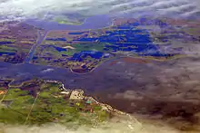
According to the United States Census Bureau, the CDP has a total area of 5.1 square miles (13 km2), all of it land. It is located on an island of the same name 9 miles (14 km) east of Antioch.[7] The island is surrounded by Taylor, Piper, Dutch and Sandmound Sloughs, and protected by 11.5 miles (18.5 km) of earthen levees. The only land access is a bridge that connects Bethel Island Road to Cypress Road in Oakley.[8]
Other nearby communities are Oakley, which adjoins Bethel Island on the west-southwest, and Brentwood, which is south of the island.
Climate
According to the Köppen Climate Classification system, Bethel Island has a warm-summer Mediterranean climate, abbreviated "Csa" on climate maps.[9]
Demographics
| Historical population | |||
|---|---|---|---|
| Census | Pop. | %± | |
| U.S. Decennial Census[10] | |||
2010
At the 2010 census Bethel Island had a population of 2,137. The population density was 384.1 people per square mile (148.3/km2). The racial makeup of Bethel Island was 1,843 (86.2%) Caucasian, 40 (1.9%) African American, 15 (0.7%) Native American, 46 (2.2%) Asian, 4 (0.2%) Pacific Islander, 119 (5.6%) from other races, and 70 (3.3%) from two or more races. Hispanic or Latino of any race were 280 people (13.1%).[11]
The census reported that 2,123 people (99.3% of the population) lived in households, 14 (0.7%) lived in non-institutionalized group quarters, and no one was institutionalized.
There were 1,026 households, 153 (14.9%) had children under the age of 18 living in them, 409 (39.9%) were opposite-sex married couples living together, 77 (7.5%) had a female householder with no husband present, 54 (5.3%) had a male householder with no wife present. There were 86 (8.4%) unmarried opposite-sex partnerships, and 7 (0.7%) same-sex married couples or partnerships. 384 households (37.4%) were one person and 166 (16.2%) had someone living alone who was 65 or older. The average household size was 2.07. There were 540 families (52.6% of households); the average family size was 2.66.
The age distribution was 260 people (12.2%) under the age of 18, 132 people (6.2%) aged 18 to 24, 326 people (15.3%) aged 25 to 44, 845 people (39.5%) aged 45 to 64, and 574 people (26.9%) who were 65 or older. The median age was 52.8 years. For every 100 females, there were 115.0 males. For every 100 females age 18 and over, there were 118.3 males.
There were 1,327 housing units at an average density of 238.5 per square mile (92.1/km2),of which 1,026 were occupied, 805 (78.5%) by the owners and 221 (21.5%) by renters. The homeowner vacancy rate was 5.6%; the rental vacancy rate was 17.0%. 1,616 people (75.6% of the population) lived in owner-occupied housing units and 507 people (23.7%) lived in rental housing units.
2000
At the 2000 census there were 2,312 people, 1,113 households, and 605 families in the CDP. The population density was 449.5 people per square mile (173.7/km2). There were 1,345 housing units at an average density of 261.5 per square mile (101.0/km2). The racial makeup of the CDP was 90.10% White, 1.43% Black or African American, 0.99% Native American, 0.95% Asian, 0.09% Pacific Islander, 2.90% from other races, and 3.55% from two or more races. 8.78% of the population were Hispanic or Latino of any race.[12] Of the 1,113 households 17.0% had children under the age of 18 living with them, 41.2% were married couples living together, 7.5% had a female householder with no husband present, and 45.6% were non-families. 35.8% of households were one person and 13.9% were one person aged 65 or older. The average household size was 2.08 and the average family size was 2.66.
The age distribution was 15.9% under the age of 18, 4.6% from 18 to 24, 24.1% from 25 to 44, 34.4% from 45 to 64, and 20.9% 65 or older. The median age was 48 years. For every 100 females, there were 104.6 males. For every 100 females age 18 and over, there were 109.3 males.
The median household income was $44,569 and the median family income was $53,929. Males had a median income of $47,431 versus $26,786 for females. The per capita income for the CDP was $26,739. About 5.3% of families and 8.8% of the population were below the poverty line, including 12.5% of those under age 18 and 8.7% of those age 65 or over.
Government
The state created Swamplands Districts #1, 102, 107 and 183 in 1894 to raise money for maintaining the levees in the California Delta. These became part of Reclamation District (RD) 1619, which was created in 1915.[6] The Bethel Island Municipal Improvement District (BIMID) was created from RD 1619 in 1960, and provides some of the same functions as a city government. BIMID currently provides levee maintenance and repairs, habitat mitigation, park services, as well as storm drain maintenance and repair. BIMID has five directors who are elected for four-year terms by registered voters living on Bethel Island.[13]
The BIMD relies on the East Contra Costa Fire Protection District (ECCFPD) for fire protection. The Contra Costa County Sheriff's Department provides police services.
Notes
See also
- California Delta
- Slough (hydrology)
References
- "Senators". State of California. Retrieved March 28, 2013.
- "Members Assembly". State of California. Retrieved March 28, 2013.
- "California's 9th Congressional District - Representatives & District Map". Civic Impulse, LLC. Retrieved March 9, 2013.
- "2016 U.S. Gazetteer Files". United States Census Bureau. Retrieved Jul 19, 2017.
- "Population and Housing Unit Estimates". Retrieved June 9, 2017.
- Leighton, Kathy. "Bethel Island History." East Contra Costa Historical Society. 2001. Accessed February 15, 2017.
- Durham, David L. (1998). California's Geographic Names: A Gazetteer of Historic and Modern Names of the State. Clovis, Calif.: Word Dancer Press. p. 602. ISBN 1-884995-14-4.
- "Welcome." Bethel Island Municipal Improvement District. Accessed February 15, 2017.
- Climate Summary for Bethel Island, California
- "Census of Population and Housing". Census.gov. Retrieved June 4, 2016.
- "2010 Census Interactive Population Search: CA - Bethel Island CDP". U.S. Census Bureau. Archived from the original on July 15, 2014. Retrieved July 12, 2014.
- "U.S. Census website". United States Census Bureau. Retrieved 2008-01-31.
- "About BIMID." Bethel Island Municipal Improvement District Accessed February 15, 2017.
External links
| Bodies of water |
|  |
|---|---|---|
| Counties | ||
| Major cities | ||
| Cities and towns 100k–250k | ||
| Cities and towns 50k–99k | ||
| Cities and towns 25k–50k | ||
| Cities and towns 10k–25k |
| |
| Sub-regions | ||
Municipalities and communities of Contra Costa County, California, United States | ||
|---|---|---|
| Cities and towns | 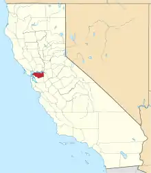 Contra Costa County map | |
| CDPs |
| |
| Former CDPs | ||
| Unincorporated communities | ||
| Ghost towns | ||
| ||