Bruxner Highway
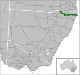
The Bruxner Highway is a 420-kilometre (260 mi)[1] state highway located in New South Wales, Australia. The highway forms an east–west link from the Northern Rivers coast, across the Northern Tablelands in northern New South Wales, close to the border with Queensland.
Bruxner Highway | |
|---|---|
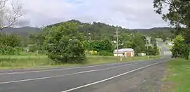 | |
The Bruxner Highway at Drake. | |
 | |
| General information | |
| Type | Highway |
| Length | 420 km (261 mi)[1] |
| Route number(s) |
|
| Former route number |
|
| Major junctions | |
| West end | |
| |
| East end | |
| Location(s) | |
| Major settlements | |
| Highway system | |
The highway was named on 2 November 1959 in honour of Sir Michael Bruxner, member for Northern Tablelands and Tenterfield from 1920 to 1962, leader of the New South Wales Country Party for almost all that period and Deputy Premier and Minister for Transport from 1932 to 1941.[2][3]
Route
The eastern terminus of the Bruxner Highway[4] is at the junction with the Pacific Highway at Ballina and links Lismore, Casino, Mummulgum, Tabulam, Drake, Tenterfield, Bonshaw, Yetman and Boggabilla where its western terminus is at a junction with the Newell Highway, close to Goondiwindi.
This state based road forms an important link between Ballina and Casino via Lismore. At Alstonville (near Ballina), a $90 million bypass has been allocated from the Federal Government at the cost of funds from the National Highway scheme. There is a proposal for a fully duplicated highway from the Pacific Highway junction to Lismore Airport. Further west from Tenterfield, the Bruxner Highway runs parallel with the Dumaresq River and the Queensland border, through Bonshaw and Yetman, onto Boggabilla and the Newell Highway, which continues over the Queensland border to Goondiwindi approximately 5 kilometres from Boggabilla over the Macintyre River.
National Route 44 was only signposted from the Pacific Highway near Ballina to the New England Highway in Tenterfield. It was intended that National Route 44 continued to Boggabilla to meet with the Newell Highway, however primarily because the highway is administered by the local government, as well as a short 4 km unsealed section between Yetman and Boggabilla, which goes against the route numbering protocol to not sign routes on unsealed roads, this part of the highway was never signed as National Route 44.
In 2013, as part of the alphanumeric route scheme, B60 replaced National Route 44 between Ballina and Tenterfield.[5]
Speed Limit
The speed limit of the Bruxner Highway is mostly 100 km/h with 80 km/h on windy sections and 50 km/h in urban areas. The speed limit is 60 km/h through the Lismore urban area with a high volume of traffic. There is a speed camera in the 80 km/h section near the Lismore City and Ballina Shire boundary.
Major intersections
| LGA | Location | km[1] | mi | Destinations | Notes | ||
|---|---|---|---|---|---|---|---|
| Moree Plains | Boggabilla | 0 | 0.0 | Western highway terminus, continues north as Newell Highway | |||
| 7.9 | 4.9 | Boggabilla–Warialda Road – North Star, Warialda | |||||
| Inverell | Yetman | 60.4 | 37.5 | ||||
| Bebo | 101 | 63 | Texas Road – Texas | ||||
| Bonshaw | 130 | 81 | Inverell–Bonshaw Road – Ashford, Inverell | ||||
| Tenterfield | Tenterfield | 230 | 140 | Eastbound traffic continues south on New England Highway | |||
| Gap in route | |||||||
| Tenterfield | Tenterfield | 235 | 146 | Westbound traffic continues north on New England Highway | |||
| Clarence River | 306 | 190 | Tabulam Bridge | ||||
| Kyogle | Tabulam | 314 | 195 | Clarence Way – Baryulgil, Grafton | |||
| Richmond Valley | Casino | 361 | 224 | B91 southern concurrency terminus; roundabout | |||
| Richmond River | 362 | 225 | Irving Bridge | ||||
| Richmond Valley | Casino | 363 | 226 | B91 northern concurrency terminus; roundabout | |||
| Lismore | South Lismore | 391 | 243 | Union Street north / Elliot Road west – Kyogle, Nimbin | Roundabout | ||
| Wilsons River | 392 | 244 | Bridge over river | ||||
| Lismore | Lismore | 393 | 244 | Roundabout | |||
| Ballina | West Ballina | 420 | 260 | Roundabout interchange; eastern highway terminus | |||
1.000 mi = 1.609 km; 1.000 km = 0.621 mi
| |||||||
References
- Google (2 June 2014). "Bruxner Highway" (Map). Google Maps. Google. Retrieved 2 June 2014.
- Aitkin, Don. "Bruxner, Sir Michael Frederick (1882–1970)". Australian Dictionary of Biography. Australian National University. Retrieved 5 April 2007.
- "The Bruxner Highway" (PDF). Main Roads. Department of Main Roads, Government of New South Wales: 59–68. March 1968. Retrieved 6 November 2016.
- "Bruxner Highway". Ozroads: the Australian Roads Website. Retrieved 9 April 2010.
- "Road number and name changes in NSW" (PDF). Roads & Maritime Services. Government of New South Wales. 2012. Archived from the original (PDF) on 25 March 2016. Retrieved 7 November 2016.
External links
![]() Media related to Bruxner Highway at Wikimedia Commons
Media related to Bruxner Highway at Wikimedia Commons