Bylong Valley Way
Bylong Valley Way is a New South Wales country road linking the Golden Highway near Sandy Hollow to the Castlereagh Highway near Ilford. It is named after the Bylong Valley, through which the road passes.
Bylong Valley Way | |
|---|---|
 | |
| General information | |
| Type | Rural road |
| Length | 138.3 km (86 mi) |
| Major junctions | |
| North-east end | |
| South-west end | |
| Location(s) | |
| Major settlements | Baerami, Kerrabee, Bylong, Breakfast Creek, Rylstone, Kandos |
Connections
In conjunction with the Bathurst-Ilford Road to Bathurst, this quiet, scenic route provides a leisurely alternative to going through Sydney to travel between the Hunter Region and Central Tablelands.
The part of the Bylong Valley Way east of Bylong is designated MR 208. At a T-intersection near the railway level crossing just north of the village of Bylong, MR 208 turns off towards Ulan, following the Ulan railway line to the west while the Bylong Valley Way becomes MR 215 as it turns south to pass through Bylong, Rylstone and Kandos.
National Park access
Access to the Wollemi National Park and Goulburn River National Park is available at various points along the road between the Golden Highway and Bylong. Over Coxs Gap, the Bylong Valley Way is flanked by the two national parks. Camping areas are available in the Wollemi National Park on the western side of Coxs Gap, and the Phipps Cutting picnic area between Baerami and Widden Creek provides an entry point for hiking in the Wollemi National Park.
Tourism
Following completion of sealing of the road, The Muswellbrook Chamber of Commerce and Industry created a web site for the road, to promote it as a tourist route.[1]
The section of the Bylong Valley Way east of Bylong is also part of two separately promoted tourist routes.
A self-drive tour loop route originating in Sandy Hollow, promoted as Upper Hunter Tourist Drive number 4, uses this section of road to travel west, then turns north on other local roads to rejoin the Golden Highway.[2] The Phipps Cutting picnic area is shown as a rest area on that route.
The Tablelands Way tourist route between Canberra and Muswellbrook uses this section of the Bylong Valley Way as part of the route between Mudgee and Muswellbrook.[3]
Sealing

The Bylong Valley Way was not fully sealed in the Mid-Western Regional Council area until February 2009. Sealing of the road had been a political issue for decades. At the beginning of 2007, there were four sections of unsealed road totalling 32 kilometres. Two sections were between Coxs Gap and Bylong with only 850 metres of sealed road between them. The other two were south of Bylong on the way towards Rylstone, where two kilometres had been sealed a few years earlier, converting one long unsealed section to two shorter ones.
On 13 December 2006, The federal government announced A$2 million of Auslink funding towards the $4.1 million cost of completion of sealing of the Bylong Valley Way.[4] Under the announced funding arrangement, the New South Wales Roads and Traffic Authority contributed $900,000 and the Mid-Western Regional Council was to contribute the remaining $1.2 million.[5] The overall cost slightly exceed the budgeted $4.1 million, with the council having to cover the overrun.[6]
The sealing work was carried out by Mid-Western Regional Council and was completed in three stages:[7]
Stage One
- March 2007 to June 2007
- Sealing of two sections totalling six kilometres south of Bylong
- Widening a total of nine kilometres of remaining unsealed road in preparation for sealing in the later stages
Stage Two
- July 2007 to June 2008
- Sealing of two remaining unsealed sections south of Bylong totalling 12.42 kilometres
- Sealing of one section one kilometre long adjacent to existing sealed section east of Bylong
- Preparatory works for stage three[8]
Stage Three
- July 2008 to March 2009
- Completion of sealing, consisting of two sections east of Bylong totalling 12.6 kilometres
Bridges

Muswellbrook Shire Council
The dilapidated timber sections of the Kirks Bridge, crossing Baerami Creek at Baerami were demolished and were planned to be replaced with new concrete sections by 31 August 2007.[9] Unfortunately, flooding during the June 2007 Hunter Region and Central Coast storms delayed the work by around a month. The bridge had previously been partially rebuilt, with both buttresses and two spans at one end having been reconstructed in concrete.[10]
Muswellbrook Shire Council maintained a temporary deviation on private property for several years to allow access during bridgework and for heavy vehicles. After the bridge was reopened, that deviation was removed and the land returned to its owner.
The single-lane timber bridge over Widden Creek has also been replaced. Muswellbrook Shire Council had committed to spend $480,000 by 30 June 2007 to Manage the investigation, design and construction works[11] but the discovery of a serious problem on Kirks Bridge saw that money diverted to the more urgent project. Muswellbrook Shire Council subsequently replaced the Widden Creek bridge between January and June 2009 at a cost of approximately A$910,000.[12]
Once the Widden Creek bridge was replaced, the 38 tonne load limit was lifted, allowing heavy vehicles to again use this route.
Railway
The Sandy Hollow–Gulgong railway line and part of the Merriwa railway line, which form the Australian Rail Track Corporation's Ulan line between Muswellbrook and Gulgong, follow the same valleys as the Bylong Valley Way from near the Golden Highway to near Bylong, where the railway line continues west as the road turns south.
The Ulan line crosses the road three times, twice at level crossings and once on a bridge over the road. One level crossing is close to the Golden Highway while the other is close to Bylong. The railway bridge is on the western side of Coxs Gap, between the level crossings.
The Gwabegar railway line crosses the road on at a level crossing the northern side of Rylstone.
All three of the level crossings have flashing warning lights but not boom gates.
Major intersections
| LGA | Location | km[14] | mi | Destinations | Notes |
|---|---|---|---|---|---|
| Muswellbrook | Sandy Hollow | 0 | 0.0 | south-east - Denman | North-eastern end of Bylong Valley Way |
| Sandy Hollow–Gulgong railway line | 0.45 | 0.28 | Level crossing at Sandy Hollow with flashing lights but no boom gates. | ||
| Goulburn River | 0.85 | 0.53 | Bridge over river (no known name) | ||
| Muswellbrook | Baerami | 8.0 | 5.0 | Yarrawa Road - east - Denman | |
| Baerami Creek | 13.9 | 8.6 | Kirks Bridge | ||
| Widden Brook | 26.2 | 16.3 | Bridge over river (no known name) | ||
| Sandy Hollow- Gulgong railway line | 59.6 | 37.0 | Level crossing at Bylong with flashing lights but no boom gates. | ||
| Mid-Western Region | Bylong | 59.6 | 37.0 | Wollar Road - north, then west - Wollar, Mudgee or Ulan & Gulgong | |
| Rylstone | 109.1 | 67.8 | Lue Road - north, then west - Lue, Mudgee | ||
| Gwabegar railway line | 112.6 | 70.0 | Level crossing at Rylstone with flashing lights but no boom gates. | ||
| Mid-Western Region | Rylstone | 114.3 | 71.0 | Fitzgerald Street to Glen Alice Road - east, then south - Glen Alice, Capertee | Bylong Valley Way passes through Rylstone as Louee Street, Cox Street, and Ilford Road. |
| 114.6 | 71.2 | Coomber Street and Carwell Street to Cudgegong Road - west, then south - Cudgegong River | |||
| Kandos | 120.5 | 74.9 | Cooper Drive - south - Charbon | T junction. Bylong Valley Way turns west (right) then south, bypassing most of Kandos. | |
| Ilford | 138.3 | 85.9 | south - Marrangaroo | South-western end of Bylong Valley Way | |
| 1.000 mi = 1.609 km; 1.000 km = 0.621 mi | |||||
Gallery
 Bridge over Goulburn River near Sandy Hollow
 Kirks Bridge at Baerami, February 2007
 Kirks Bridge at Baerami after timber section was demolished, April 2007
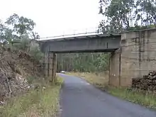
 Single lane bridge across Widden Creek
 Level crossing where the line crosses Bylong Valley Way near Sandy Hollow
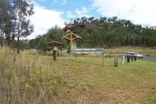
 The railway level crossing and turnoff to Mudgee via Wollar, just north of the village of Bylong
References
- The Bylong Valley Way tourist web site
- "Sandy Hollow self-drive tour loop".
- http://www.tablelandsway.com.au/ The Tablelands Way web site
- "Auslink Strategic Regional Program - Projects selected for funding" (PDF). Archived from the original (PDF) on 29 August 2007. Retrieved 9 February 2007.
- NSW Nationals announcement of funding for Bylong Valley Way
- http://www.midwestern.nsw.gov.au/files/Executive/Attachment_-_Corporate.pdf Mid-Western Regional Council 2008/2009 Management Plan, monthly report January 2009
- Auslink details of project for sealing of Bylong Valley Way
- Mid-Western Regional Council - Quarterly Review, June 2008
- "Muswellbrook Shire Council tender documents for bridge construction". Archived from the original on 27 September 2007. Retrieved 9 March 2007.
- Muswellbrook Shire Council 2004-2005 capital expenditure report
- "Muswellbrook Shire Council 2006-2007 management plan" (PDF). Archived from the original (PDF) on 21 February 2007. Retrieved 29 April 2007.
- Cordell Connect - Project : WIDDEN CREEK BRIDGE
- Mid-Western Regional Council 2007-2008 management plan
- Google (12 October 2018). "Bylong Valley Way" (Map). Google Maps. Google. Retrieved 12 October 2018.
External links
![]() Media related to Bylong Valley Way at Wikimedia Commons
Media related to Bylong Valley Way at Wikimedia Commons