Summerland Way
The Summerland Way is a 199–kilometre state route, designated B91, in New South Wales. It runs generally north from Grafton to the border[1] between NSW and Queensland just west of Mount Lindesay. The road continues from there into Queensland as Mount Lindesay Highway. With the decommissioning of the Mount Lindesay Highway in New South Wales in 1982, the length of the Summerland Way was increased by 9.4 km to the Queensland border.[2] It is sealed for its entire length, although some of the road north of the Lions Road turn-off is narrow and winding. In 1996, the Federal Government committed $20 million toward upgrading the Summerland Way. A $7 million contract to realign 1.2 km at Dourrigan's Gap, approximately 16 km north of Kyogle, was awarded, with work starting in February 2002 and expected to take 12 months to complete.[3]
Summerland Way | |
|---|---|
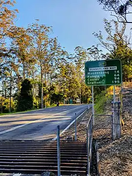 | |
Summerland Way's North End at NSW/QLD Border | |
| General information | |
| Type | Highway |
| Length | 199 km (124 mi) |
| Route number(s) | |
| Former route number | |
| Major junctions | |
| North end | 15 km east of Woodenbong, New South Wales (NSW/Qld Border) |
| South end | South Grafton, New South Wales |
| Location(s) | |
| Major settlements | Kyogle, Casino, Grafton |
| Highway system | |
It was so named as the region in runs through is a popular tourist area for people during summer.
The Summerland Way is an alternative route to the Pacific Highway.
The highway crosses the Clarence River via the New Grafton Bridge, and previously the original Grafton Bridge prior to 2019.[4][5]
History
Grafton
European settlement along the Clarence River had reached the area where Grafton now stands in the 1830s, with a store and shipyard being established at South Grafton in 1839. By the early 1840s there was a wharf, a store and an inn on the northern bank of the river.[6]
Prior to 1861, when a punt service began operating on the river, the only way to cross was by rowboat. A steam-driven vehicular ferry began operating in the mid-1860s.[6] This increased the need for a reliable road to areas north of Grafton.
By 1905 the Casino to North Grafton section of the North Coast railway line had been completed, but there was no rail connection to the south until 1915, when the North Coast railway line reached South Grafton and services were connected by a rail ferry that transported railcars across the river.[7]
In 1932, a bridge across the Clarence River with a unique design of two storeys with the railway running underneath the road, known as Grafton Bridge, was opened.[6] This led to a further increase in motor vehicle traffic to the north, and to a need for road improvements.
In December 2019, the New Grafton Bridge opened and runs parallel to the original bridge. Summerland Way was permanently rerouted via Villers Street, Pound Street and the new bridge, and no longer runs along Prince, Fitzroy, Craig and Bent Streets.[4] The new route bypasses the Grafton city centre and avoids the low 3.5m clearance rail bridge over Prince Street. When the Pacific Highway through Grafton was bypassed in May 2020, the B91 route (but not Summerland Way) was further extended along the old Pacific Highway (now Big River Way) and interchange with Pacific Highway at Glenugie.[5]
Casino
European settlement along the Richmond River had reached the area where Casino now stands in the early 1850s, when a village known as “The Falls” was established on the northern side. In 1876 a bridge across the Richmond River to the settlement was completed, enabling road access from Grafton in the south and on to Kyogle in the north. The road was the only means of travel to Grafton until 1905, when the railway reached the town.[8]
Kyogle
In the 1830s a huge property, known as “Richmond Head”, was established in the upper Richmond River valley. The area around what is now Kyogle was settled throughout the 1840s and 1850s, but the name “Kyogle” was not used before 1899. In the 1860s cedar cutters arrived and for the next thirty years tree felling and sawmilling were the district's most important industries.[9] These industries made roads to where they worked, substantially contributing to the road network of the district.
Road access from Casino was facilitated by the opening of the bridge at Casino in 1876. The road was the only means of travel to Casino until 1910, when the railway reached Kyogle.[9]
Mount Lindesay
In 1928 the NSW Main Roads Board declared the route of what would later become Mount Lindesay Highway (NSW) as part of State Highway No. 9 – Great Northern Highway, although part of it had not yet been built. Construction of the “missing link” between Woodenbong and Mount Lindesay was completed in 1929, and a section west of Woodenbong was reconstructed by 1934.[10]
In 1935 the Summerland Way was constructed between Casino and the recently completed highway. During World War II the road was improved as an inland, flood-free route to Brisbane which avoided the problems associated with the Clarence River and its two ferry crossings.[9]
Major intersections
| LGA | Location | km[11] | mi | Destinations | Notes |
|---|---|---|---|---|---|
| Clarence Valley | South Grafton | 0 | 0.0 | south-east - South Grafton, and to | Southern end of Summerland Way. B91 continues southwards along Big River Way |
| Clarence River | 1.0– 1.3 | 0.62– 0.81 | New Grafton Bridge | ||
| Clarence Valley | Grafton | 2.0 | 1.2 | Villiers Street - south-west - Grafton / Pound Street - north-west - Grafton | Four-way roundabout. Summerland Way continues north-east (turn right) on Villers Street. |
| North Coast railway line | 2.1 | 1.3 | Railway line on bridge over road - clearance 5m. | ||
| Clarence Valley | Grafton | 3.1 | 1.9 | Dobie Street - south-east - Grafton / Villers Street - north-east - Grafton | Four-way roundabout. Summerland Way continues north-west (turn left) on Dobie Street. |
| 3.5 | 2.2 | Prince Street - Grafton | Four-way roundabout | ||
| 4.5 | 2.8 | Turf Street - south-west - Grafton | T junction. Summerland Way continues north-east (turn right) on Turf Street | ||
| North Coast railway line | 11.5 | 7.1 | Level crossing at Koolkhan with boom gates and flashing lights.[12] | ||
| Clarence Valley | Mountain View | 13.1 | 8.1 | Clarence Way - north-west - Copmanhurst | |
| Banyabba | 40.2 | 25.0 | Pringles Way - south-east - Lawrence | ||
| Richmond Valley | Casino | 102.7 | 63.8 | Hare Street (becomes Casino-Coraki Road) - east - Tatham | Southern concurrency terminus with Bruxner Highway (B60) |
| Richmond River | 103.1 | 64.1 | Irving Bridge[13] | ||
| Richmond Valley | Casino | 104.2 | 64.7 | Centre Street - north - Casino | Four-way roundabout. Northern concurrency terminus with Bruxner Highway (B60). Summerland Way continues west (turn left). |
| 104.4 | 64.9 | West Street - south - Casino | T junction. Summerland Way continues north (turn right). | ||
| Murwillumbah railway line | 104.8 | 65.1 | Level crossing in Casino with flashing lights.[12] | ||
| North Coast railway line | 108.6 | 67.5 | Level crossing at Nammoona with boom gates and flashing lights.[12] | ||
| Kyogle | Kyogle | 134.7 | 83.7 | Kyogle Road - north-east - Murwillumbah | Y junction. Summerland Way continues north-west (veer left) |
| North Coast railway line | 147.3 | 91.5 | Level crossing at Wiangaree with flashing lights.[12] | ||
| Richmond River | 149.0 | 92.6 | Jenny Constable Bridge[14] The road follows the upper reaches of the Richmond River, crossing it five more times. | ||
| Kyogle | The Risk | 153.4 | 95.3 | Gradys Creek Road - north - Rathdowney, Queensland (via Lions Road) | T junction from Gradys Creek Road |
| Lindesay Creek / Dairy Flat border | 189.2 | 117.6 | Mount Lindesay Road - south-west - Woodenbong | T junction. Summerland Way continues north-east (turn right) | |
| NSW - Queensland border | 198.6 | 123.4 | Northern end of Summerland Way. Road becomes Mount Lindesay Highway (National Route 13) in Queensland. | ||
1.000 mi = 1.609 km; 1.000 km = 0.621 mi
| |||||
References
- "Schedule of Classified Roads And State and Regional Roads" (PDF). Roads and Maritime Services. April 2017. p. 6 (Gazetted Road Number 83). Retrieved 8 January 2018.
- "Schedule of Classified Roads And State and Regional Roads" (PDF). Roads and Maritime Services. April 2017. p. 25 (Gazetted Road Number 622). Retrieved 8 January 2018.
- "Federal Government keeps New South Wales moving - Attachment - Summerland Way". Australian Government. 14 May 2002. Retrieved 9 January 2018.
- "New Grafton Bridge - Proposed directional signage plan - Stage 2 - Bridge opening (Target Opening Date - December 2019)" (PDF). Transport for NSW - Roads and Maritime. Retrieved 3 December 2020.
- "New Grafton Bridge - Proposed directional signage plan - Stage 3 - Project completion (Target Date - June 2020)" (PDF). Transport for NSW - Roads and Maritime. Retrieved 3 December 2020.
- "Grafton, NSW". Aussie Towns. Retrieved 11 January 2018.
- "Grafton City Station (South Grafton)". NSWrail.net. NSW Rail. Retrieved 11 January 2018.
- "Casino, NSW". Aussie Towns. Retrieved 11 January 2018.
- "Kyogle, NSW". Aussie Towns. Retrieved 11 January 2018.
- "Mount Lindesay Highway, NSW". Ozroads. Retrieved 11 January 2018.
- Google (8 January 2018). "Summerland Way" (Map). Google Maps. Google. Retrieved 8 January 2018.
- "SUMMERLAND WAY DRAFT CORRIDOR STRATEGY" (PDF). NSW Government. September 2016. Retrieved 8 January 2018.
Page 28 Railway Level Crossings
- "Irving Bridge". Geocaching. 25 October 2017. Retrieved 8 January 2018.
- "Kyogle Tourist Drive Number 2" (PDF). Kyogle Council. Retrieved 8 January 2018.
External links
- Mt Lindesay Road, ozroads