Ch'iyar Juqhu River
The Ch'iyar Juqhu River (Aymara Ch'iyar Juqhu Jawira, ch'iyara black, juqhu muddy place, jawira river,[1] "black muddy river", Hispanicized spellings Chiar Jokho, Chiar Joko) is a Bolivian river east of Lake Titicaca in the La Paz Department. It originates in the Cordillera Real near the peaks of the 6,127 m high Ch'iyar Juqhu which is probably named after the river or the region around it and the 5,871 m high Qalsata and flows down towards the Altiplano.
| Ch'iyar Juqhu Chiar Jokho / Chiar Joko | |
|---|---|
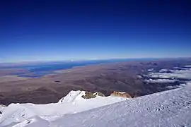 Lake Titicaca as seen from the summit of Janq'u Uma. The mouth of the Ch'iyar Juqhu River is visible in the left edge of this image. | |
| Etymology | Aymara |
| Location | |
| Country | Bolivia |
| Region | La Paz Department |
| Physical characteristics | |
| Source | Cordillera Real |
| • location | Los Andes Province |
| Mouth | |
• location | Omasuyos Province, La Paz Department |
At first the river flows in a southwestern direction. Near the village of Qurpa Putu (Corpa Puto) in the Achacachi Municipality it turns to the northwest unifying with more rivers to end in Lake Titicaca near the mouth of the Jach'a Jawira.[2]
References
- Radio San Gabriel, "Instituto Radiofonico de Promoción Aymara" (IRPA) 1993, Republicado por Instituto de las Lenguas y Literaturas Andinas-Amazónicas (ILLLA-A) 2011, Transcripción del Vocabulario de la Lengua Aymara, P. Ludovico Bertonio 1612 (Spanish-Aymara-Aymara-Spanish dictionary)
- Achacachi Municipality: population data and map Archived 2014-10-29 at the Wayback Machine
See also

This article is issued from Wikipedia. The text is licensed under Creative Commons - Attribution - Sharealike. Additional terms may apply for the media files.