Pelechuco Municipality
Pelechuco Municipality is the second municipal section of the Franz Tamayo Province in the La Paz Department, Bolivia. IN 2001 it had apopulation of 5,115. Its seat is Pelechuco.
Pelechuco Municipality | |
|---|---|
Municipality | |
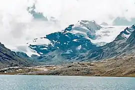 Jach'a Waracha as seen from the west, Pelechuco Municipality | |
 Pelechuco Municipality Location of the Pelechuco Municipality within Bolivia | |
| Coordinates: 14°45′0″S 69°5′0″W | |
| Country | |
| Department | La Paz Department |
| Province | Franz Tamayo Province |
| Seat | Pelechuco |
| Government | |
| • Mayor | Daniel Cama Mamani (2007) |
| • President | Florencio Condori Mamani (2007) |
| Area | |
| • Total | 968 sq mi (2,507 km2) |
| Elevation | 12,800 ft (3,900 m) |
| Population (2001) | |
| • Total | 5,115 |
The municipality is bordered to the north by the Apolo Municipality, to the east by the Apolo and Curva Municipalities, to the south by the Curva and Charazani Municipalities and to the west by Peru.
Geography
The Apolobamba mountain range traverses the municipality. The highest mountain of the municipality is Chawpi Urqu (Wisk'achani) at 6,044 m (19,829 ft). Other mountains are listed below:[1][2]
Division
Pelechuco Municipality is subdivided into the following four cantons:[3]
- Antaquilla de Copacabana - 964 inhabitants (2001)
- Pelechuco - 2,756 inhabitants
- Suches - 227 inhabitants
- Ulla Ulla - 1,168 inhabitants
Places of interest
Some of the tourist attractions of the municipalities are:[4]
- Katantica, one of the most important peaks of the Apolobamba mountain range, about 5,592 m high, in Pelechuco Canton
- the colonial town of Pelechuco
- the village of Queara near Pelechuco which is also situated in the highest area of Madidi National Park
- the Ulla Ulla National Reserve in Ulla Ulla Canton which today is part of the Apolobamba Integrated Management Natural Area
- the pre-Hispanic Guanan ruins in Pelechuco Canton
- Cololo Lake in Antaquilla de Copacabana Canton
- Suches Lake on the border to Peru
See also
References
- IGM map 1:100,000 3041 Pelechuco
- BIGM map 1:100,000 Umanata 3040
- National Institute of Statistics of Bolivia
- www.gobernacionlapaz.gob.bo Archived 2011-05-09 at the Wayback Machine Tourist guide by the government of the department
External links

This article is issued from Wikipedia. The text is licensed under Creative Commons - Attribution - Sharealike. Additional terms may apply for the media files.