José Manuel Pando Province
José Manuel Pando is a province in the La Paz Department in Bolivia. It was founded on April 22, 1986 during the presidency of Víctor Paz Estenssoro. The province was named after José Manuel Pando (1848-1917) who was the president of Bolivia from 1899 till 1904. Its capital is Santiago de Machaca.
José Manuel Pando | |
|---|---|
Province | |
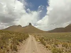 Nuñu Qullu ("breast mountain") in the Santiago de Machaca Municipality | |
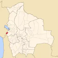 Location of José Manuel Pando Province within Bolivia | |
 Provinces of the La Paz Department | |
| Coordinates: 17°10′0″S 69°20′0″W | |
| Country | |
| Department | La Paz Department |
| Municipalities | 2 |
| Founded | April 22, 1986 |
| Capital | Santiago de Machaca |
| Area | |
| • Total | 1,976 km2 (763 sq mi) |
| Elevation | 3,893 m (12,772 ft) |
| Population (2012 census) | |
| • Total | 7,381 |
| • Density | 3.7/km2 (9.7/sq mi) |
| • Ethnicities | Aymara |
| Website | Official website |
The province is situated in the western part of the Bolivian Altiplano, south of Lake Titicaca. To the west it is bordered by Peru, to the southeast by the Pacajes Province and to the northeast by the Ingavi Province.
Geography
Some of the highest mountains of the province are listed below:[1][2]
- Apachita
- Ch'alla Willk'i
- Ch'iyar Jaqhi
- Jach'a Qiñwa Qullu
- Janq'u Qullu
- Jichu Kunka
- Jisk'a Qiñwa Qullu
- Jisk'a Wari Kunka
- Katari
- Laram Q'awa
- Llallawa
- Misa Willk'i
- P'iq'iñ Q'ara
- Qiñwani
- Qiwñuyu
- Qutani
- Sinijawi
- Sirk'i volcano
- Tatitu Qullu
- Wari Kunka
- Wila Qullu
- Wila Willk'i
Subdivision
The province is divided into two municipalities which are further subdivided into cantons.
| Municipality | Inhabitants (2001) [3] | Seat | Inhabitants (2001) |
|---|---|---|---|
| Santiago de Machaca Municipality | 4,402 | Santiago de Machaca | 819 |
| Catacora Municipality | 1,735 | Catacora | 529 |
See also
References
- Bolivian IGM map 1:50,000 Berenguela 5742-II
- IGM map 1:50,000 Sinejavi 5742-III
- Instituto Nacional de Estadística Archived 2009-11-13 at the Wayback Machine (Spanish)
This article is issued from Wikipedia. The text is licensed under Creative Commons - Attribution - Sharealike. Additional terms may apply for the media files.