Pedro Domingo Murillo Province
Pedro Domingo Murillo is a province in the Bolivian La Paz Department. It was created on January 8, 1838, with the name Cercado and on October 17, 1912, during the presidency of Eliodoro Villazón, its name was changed in honor of Pedro Domingo Murillo, protagonist of the revolution of June 16, 1809.[1]
Pedro Domingo Murillo | |
|---|---|
Province | |
.jpg.webp) Valle de la Luna ("Moon Valley") | |
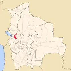 Location of Pedro Domingo Murillo Province within Bolivia | |
 Provinces of the La Paz Department | |
| Coordinates: 16°30′0″S 68°0′0″W | |
| Country | |
| Department | La Paz Department |
| Municipalities | 5 |
| Foundation | October 17, 1912 |
| Capital | Palca |
| Area | |
| • Total | 4,705 km2 (1,817 sq mi) |
| Population (2012 census) | |
| • Total | 1,663,099 |
| • Density | 350/km2 (920/sq mi) |
| • Ethnicities | Aymara Quechua |
| Website | Official website |
The province contains the Bolivian administrative capital, La Paz, as well as the major city of El Alto.
Geography
The Cordillera Real traverses the province. Illimani, the highest peak of the range, lies in the province. Other mountains are listed below:[2][3][4]
- Achachi Qala
- Chankuni
- Chuqi Tanka
- Churu Pata
- Ch'alla Willk'i
- Ch'iyar Qirini
- Ch'iyar Qullu (Murillo)
- Ch'iyar Qullu (Palca)
- Ch'uñawi
- Jach'a Chukita
- Jallayku
- Jamp'aturi
- Janq'u K'ark'a
- Jisk'a Chukita
- Jist'aña
- Jukumarini
- Kunturiri (La Paz)
- Kunturiri (Palca)
- Layqa Qullu
- Link'u Link'u
- Llamp'u
- Llust'a
- Maman Quta
- Mik'aya
- Parqu Quta
- Pukara
- Phisqa Quta
- P'iq'iñ Q'ara (Palca)
- P'iq'iñ Q'ara (Mecapaca)
- Qala Wathiyani
- Qutapata
- Q'asiri
- Q'ulini
- Salla Jipiña
- Sankayuni
- Silla Pata
- Sirk'i Qullu
- Tata Ch'iyar Qullu
- Taypi Qullu
- Tilata
- Turini
- Thipata
- Ullumani
- Urqu Jawira
- Uyu K'uchu
- Wak'ani
- Wila Jamach'ini
- Wila Lluxita
- Wila Quta
- Wisk'achani
Subdivision
Pedro Domingo Murillo Province is divided into five municipalities.
| Municipality | Inhabitants (2001) [5] | Seat | Inhabitants (2001) |
|---|---|---|---|
| La Paz Municipality | 793,293 | La Paz | 789,585 |
| Palca Municipality | 14,185 | Palca | 894 |
| Mecapaca Municipality | 11,782 | Mecapaca | 251 |
| Achocalla Municipality | 15,110 | Achocalla | 10,369 |
| El Alto Municipality | 649,958 | El Alto | 647,350 |
Places of interest
Some of the tourist attractions of the municipality are:[6]
- In the La Paz Municipality:
- Wayna Potosí, a mountain about 15 km north west of La Paz
- Qutapata National Park and Integrated Management Natural Area
- La Cumbre at a height of 4,650 m above sea level, the highest point on the route between La Paz and the Yungas
- K'ili K'ili viewpoint which presents a panoramic view of the city of La Paz
- Muela del Diablo ("devil' tooth"), a giant rock of about 150 m height that has the shape of a tooth
- Valle de la Luna ("moon valley"), south of La Paz city
- La Paz zoo "Vesty Pakos Sofra" with an area of 22.4 ha, the largest zoo in Bolivia, the second largest in South America and the highest in the world.
- Inkachaka Dam
- In the Palca Municipality:
- Apachita viewpoint in the Palca Canton which offers a sight of the contrasting landscape and snowcapped Illimani
- Valle de los Ánimas ("valley of the souls") and its lake (Laguna de las Ánimas) in the Palca Canton
- the town of Palca with houses of colonial times, Palca River, Chuaqueri gorge, also known as Palca gorge, and Takesi pre-Columbian trail in the Palca Canton
- the communities of Quilihuaya and Pinaya in the Quilihuaya Canton
- the community of Cohoni, its church dating from the 17th century and the chullpa of Ch'ullu Cahinbaya in the Cohoni Canton
References
- El Diario (Spanish)
- IGM map 1:50,000 Chulumani 3338, 5945-II Milluni and Palca 6044-III
- Bolivian IGM map 1:100,000 La Paz (Norte) 3238-I
- Bolivian IGM map 1:50,000 Zongo 5945-I
- Instituto Nacional de Estadística Archived 2009-10-27 at the Wayback Machine (Spanish)
- www.gobernacionlapaz.gob.bo Archived 2011-05-09 at the Wayback Machine Tourist guide by the government of the department

This article is issued from Wikipedia. The text is licensed under Creative Commons - Attribution - Sharealike. Additional terms may apply for the media files.