Aroma Province
Aroma is one of the twenty provinces of the Bolivian La Paz Department. It is situated in the southern parts of the department. Its seat is Sica Sica (Sika Sika).
Aroma | |
|---|---|
Province | |
 | |
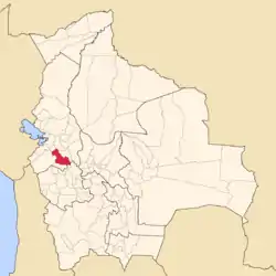 Location of Aroma Province within Bolivia | |
 Provinces of the La Paz Department | |
| Coordinates: 17°20′0″S 67°50′0″W | |
| Country | |
| Department | La Paz Department |
| Capital | Sica Sica (Sika Sika) |
| Area | |
| • Total | 4,510 km2 (1,740 sq mi) |
| Population (2012 census) | |
| • Total | 97,364 |
| • Density | 22/km2 (56/sq mi) |
| • Ethnicities | Aymara |
Location
Aroma province is located between 16° 43' and 17° 35' South and between 67° 22' and 68° 23' West. It extends over 120 km from north west to south east, and up to 55 km from north east to south west.
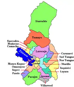
The province is situated on the Bolivian Altiplano south east of Lake Titicaca and borders Ingavi Province in the north west, Pacajes Province in the west, Gualberto Villarroel Province in the south, Oruro Department in the south east, Loayza Province in the east, and Pedro Domingo Murillo Province in the north.
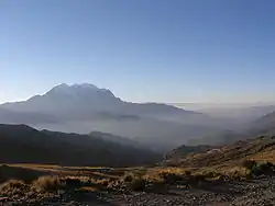
Geography
Some of the highest mountains of the province are listed below:[1]
- Aya Wayku Apachita
- Chullunkhäni
- Chuqi Q'awa
- Chuqi Sillani
- Chuwalla
- Chuwallani
- Inka Pukara
- Janq'u Jaqhi
- Janq'u Uta
- Jaqhi Chata
- Llallawa (Patacamaya)
- Llallawa (Sica Sica)
- Lluqu Lluqu
- Lluxita Punta
- Malla Jaqhi
- Millu Jaqhi
- Misk'i Wat'a
- Puna Pata
- Qillqatiri
- Qhapaqa
- Q'ara Willk'i
- Sipi Sipi
- Tanka Tanka
- Titiri
- Wayrata Punta
- Wila Pukara
- Wisk'achani
Population
The population of Aroma Province has increased by 80% over the recent two decades:
- 1992: 65,730 inhabitants (census)
- 2001: 86,480 inhabitants (census)
- 2005: 99,162 inhabitants (est.)[2]
- 2010: 110,418 inhabitants (est.)[3]
45.1% of the population are younger than 15 years old. (1992)
79.9% of the population speak Spanish, 93.9% speak Aymara, and 6.7% Quechua. (2001)
The literacy rate of the population of the province is 78.4%. (1992)
82.1% of the population have no access to electricity, 88.0% have no sanitary facilities. (1992)
69.2% of the population are Catholics, 25.5% are Protestants. (1992)
Division
The province comprises seven municipios which are further subdivided into cantons.
| Section | Municipality | Inhabitants (2001)[4] | Seat | Inhabitants (2001)[4] |
|---|---|---|---|---|
| 1st | Sica Sica Municipality | 26,818 | Sica Sica | 3,831 |
| 2nd | Umala Municipality | 9,583 | Umala | 152 |
| 3rd | Ayo Ayo Municipality | 6,981 | Ayo Ayo | 647 |
| 4th | Calamarca Municipality | 12,112 | Calamarca | 943 |
| 5th | Patacamaya Municipality | 20,039 | Patacamaya | 8,414 |
| 6th | Colquencha Municipality | 8,020 | Colquencha | 2,352 |
| 7th | Collana Municipality | 2,927 | Collana | 1,936 |
References
- IGM map 1:50,000 Sicasica 6042-II
- Instituto Nacional de Estadística Archived August 25, 2007, at the Wayback Machine
- Instituto Nacional de Estadística - Proyecciones Archived 2008-09-11 at the Wayback Machine
- National Institute of Statistics of Bolivia Archived 2009-10-27 at the Wayback Machine (in Spanish)

