Omasuyos Province
Omasuyos (Hispanicized spelling) or Uma Suyu[1] (Aymara uma water, suyu region, "water region")[2] is a province in the La Paz Department in Bolivia. Its capital is Achacachi (Jach'a Q'achi).
Omasuyos
Uma Suyu | |
|---|---|
Province | |
 | |
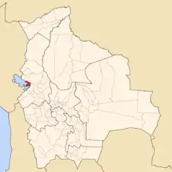 Location of Omasuyos Province within Bolivia | |
 Provinces of the La Paz Department | |
| Coordinates: 16°3′0″S 68°38′0″W | |
| Country | |
| Department | La Paz Department |
| Municipalities | 4 |
| Capital | Achacachi |
| Area | |
| • Total | 2,065 km2 (797 sq mi) |
| Population (2012 census) | |
| • Total | 84,484 |
| • Density | 41/km2 (110/sq mi) |
| • Ethnicities | Aymara |
| Area code(s) | BO.LP.FT |
| Website | Official website |
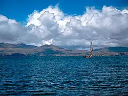
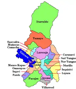
The province is situated in the Altiplano bordered to the north by the Muñecas Province, to the northeast by the Larecaja Province, to the southeast by the Los Andes Province, to the south and west by Lake Titicaca and to the northwest by the Eliodoro Camacho Province.
Geography
The Cordillera Real traverses the province. Some of the highest mountains of the province are listed below:[3][4][5]
- Chiwanqu
- Ch'amaka Misa
- Ch'umani
- Inkawi
- Jach'a Pata
- Jach'a P'iq'iñ Q'ara
- Janq'u K'ark'a
- Jichu Qullu
- Kimsa Chatani
- Muru Qullu
- Paqu Juqhu
- Pinkilluni
- Pukara
- Pukarani
- P'iq'iñ Q'ara
- Qala Qala
- Qutu Uma Qullu
- Q'ara Qullu (Achacachi)
- Q'ara Qullu (Ancoraimes)
- Taypi K'ark'a
- Wari Qalluni Pata
- Wila Sirka
- Wisk'achani
Subdivision
The province is divided into six municipalities.[6][7]
| Municipality | Inhabitants (2001) [8] | Inhabitants
(2012)[9] |
Seat | Inhabitants (2001) |
|---|---|---|---|---|
| Achacachi | 70,503 | 46,058 | Achacachi | 7,540 |
| Huarina | (included in Achacachi in 2001) | 7,948 | Huarina | 1,308 |
| Santiago de Huata | 8,562 | Santiago de Huata | 576 | |
| Huatajata | 3,927 | Huatajata | 576 | |
| Chua Cocani | 5,003 | Chua Cocani | 852 | |
| Ancoraimes | 15,199 | 13,136 | Ancoraimes | 561 |
° including separated cantons
Huarina and Santiago de Huata, and Huatajata and Chua Cocani received the status of municipalities in 2005, 2009, and 2010, respectively. Formerly they were cantons of the Achacachi Municipality.
See also
References
- Yaticha Kamani / Ministerio de Educación, Aymara aru thakhinchawi, Chuqi Yapu 2011
- Radio San Gabriel, "Instituto Radiofonico de Promoción Aymara" (IRPA) 1993, Republicado por Instituto de las Lenguas y Literaturas Andinas-Amazónicas (ILLLA-A) 2011, Transcripción del Vocabulario de la Lengua Aymara, P. Ludovico Bertonio 1612 (Spanish-Aymara-Aymara-Spanish dictionary)
- Bolivian IGM map 1:50,000 5846-III Ancoraimes
- Bolivian IGM map 1:50,000 5846-IV Mina Matilde
- "Ancoraimes". INE, Bolivia. Archived from the original on February 15, 2016. Retrieved February 10, 2016. labelled (Khara Kella)
- www.bolivia.com (Spanish)
- www.planguarani.com Archived 2011-07-15 at the Wayback Machine (Spanish)
- National Institute of Statistics of Bolivia Archived 2009-10-27 at the Wayback Machine (Spanish)
- Instituto Nacional de Estadística. "Ficha Resúmen Censo de Poblacion y Vivienda 2012". Retrieved 19 September 2017.
External links
![]() Media related to Omasuyos Province at Wikimedia Commons
Media related to Omasuyos Province at Wikimedia Commons
