Wakhjir Pass
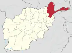
The Wakhjir Pass,[1] also spelled Vakhjir Pass, is a mountain pass in the Hindu Kush or Pamirs at the eastern end of the Wakhan Corridor, the only potentially navigable pass between Afghanistan and China in the modern era. It links Wakhan in Afghanistan with the Tashkurgan Tajik Autonomous County in Xinjiang, China, at an altitude of 4,923 metres (16,152 ft),[2] but the pass is not an official border crossing point. With a difference of 3.5 hours, the border has the sharpest official change of clocks of any international frontier (UTC+4:30 in Afghanistan to UTC+8, in China).[3] China refers to the pass as South Wakhjir Pass (Chinese: 南瓦根基达坂), as there is a northern pass on the Chinese side.[2]
| Wakhjir Pass | |
|---|---|
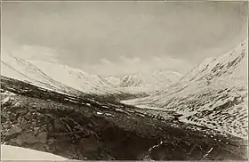 Photo of the valley before the pass by Aurel Stein | |
| Elevation | 4,923 m (16,152 ft) |
| Traversed by | Pamir Mountains |
| Location | Badakhshan Province, Afghanistan Xinjiang, China |
| Range | Pamirs |
| Coordinates | 37°05′14″N 74°29′03″E |
 Location in Afghanistan  Wakhjir Pass (Tajikistan) 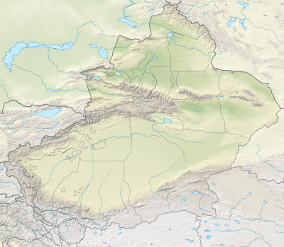 Wakhjir Pass (Xinjiang) | |
| Wakhjir Pass | |||||||||
|---|---|---|---|---|---|---|---|---|---|
| Chinese name | |||||||||
| Traditional Chinese | 瓦根基達坂 | ||||||||
| Simplified Chinese | 瓦根基达坂 | ||||||||
| |||||||||
| Alternative Chinese name | |||||||||
| Traditional Chinese | 瓦赫吉爾山口 | ||||||||
| Simplified Chinese | 瓦赫吉尔山口 | ||||||||
| |||||||||
| Persian name | |||||||||
| Persian | گذرگاه واخجیر Gozargāh-e Vākhjīr | ||||||||
Overview
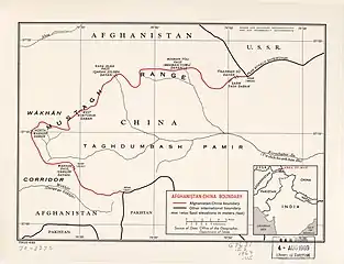
There is no road across the pass. On the Chinese side, the immediate region is only accessible to military personnel.[4] A 92 kilometres (57 mi)- long barbed wire fence was erected on the border, and there is a Chinese border guard outpost at Keketuluke just 20 kilometres (12 mi) east of the pass.[5] In the summer of 2009, the Chinese Ministry of National Defense began construction of a new road to within 10 kilometres (6.2 mi) of the border for use by border guards.[6] The road leads through the Taghdumbash Pamir to the Karakoram Highway 80 kilometres (50 mi) away. The valley to the east of Wakhjir Pass on the Chinese side is called Chalachigu Valley. It is entirely closed to visitors; however, local residents and herders from the area are permitted access. The Chinese refers to it as the portion of Wakhan Corridor in China.
On the Afghan side, the nearest road is a rough road to Sarhad-e Wakhan (also known as Sarhad-e Broghil), about 100 kilometres (62 mi) from the pass by paths.[7] Just below the pass on the Afghan side is an ice cave, at an altitude of 4,554 metres (14,941 ft). This is the source of the Wakhjir River, which ultimately flows to the Amu Darya (Oxus). The cave is therefore claimed as a source of the Amu Darya. Dilisang Pass, to Pakistan, is in the same valley about 20 kilometres (12 mi) away.[4]
History
Traditionally, the pass is inaccessible for at least five months out of the year and is accessible irregularly for the remainder of the year.[8] The terrain is extremely difficult, although Aurel Stein reported that the immediate approaches to the pass were "remarkably easy".[9] There are few records of successful crossings by foreigners. Historically, the pass was a trading route between Badakhshan and Yarkand used by merchants from Bajaor.[9] Wakhjir Pass is part of the Silk Road. It is believed that the Chinese Buddhist pilgrim Xuanzang traveled via this pass on his return trip to China in approximately 649 AD.[10] Marco Polo purportedly crossed the pass when he traveled through the Pamirs, although he did not mention the pass by name.[11] The Jesuit priest Benedict Goëz crossed from the Wakhan to China between 1602 and 1606. The next oldest accounts are from the period of the Great Game in the late 19th century.[12] In 1868, a pundit known as the Mirza, working for the Great Trigonometric Survey of India, crossed the pass.[13] There were further crossings in 1874 by Captain T.E. Gordon of the British Army,[14] in 1891 by Francis Younghusband,[15] and in 1894 by Lord Curzon.[16] In May 1906, Sir Aurel Stein crossed the pass and reported that at that time, the pass was used by only 100 pony loads of goods each way annually.[17] Since then, the only Westerner to have crossed the pass seems to have been H.W. Tilman in 1947.[18]
In 1895 the pass was established as the border between China and Afghanistan in an agreement between the British and the Russians, although the Chinese and Afghans did not finally agree on the border until 1963.[2][19]
It is believed that in more recent times, the pass is sometimes used as a low-intensity drug smuggling route, and is used to transport opium made in Afghanistan to China.[20] Afghanistan has asked China on several occasions to open the border in the Wakhan Corridor for economic reasons or as an alternative supply route for fighting the Taliban insurgency. However, China has resisted, largely due to unrest in its far western province of Xinjiang, which borders the corridor.[21][22] In December 2009, it was reported that the United States had asked China to open the corridor.[23]
See also
Notes
- From map: "NAMES AND BOUNDARY REPRESENTATION ARE NOT NECESSARILY AUTHORITATIVE"
References
- Ludwig W. Adamec. Historical and political gazetteer of Afghanistan Vol. 1. Badakhshan Province and northeastern Afghanistan. Graz : Akad. Druck- und Verl.-Anst., 1972.p. 185.
- . 1963-11-22 – via Wikisource.
passing through South Wakhjir Daban (Called Wakhjir Pass on the Afghan map) at the elevation of 4,923 meters, North Wakhjir Daban (named on the Chinese map only))
- https://www.insider.com/afghanistan-china-tiny-46-mile-border-what-it-is-like-2019-6 Afghanistan shares a tiny 46-mile border with China — here's the intriguing story of how the 2 countries became neighbors
- Dufour, Julien. "Pamir & Wakhan - Getting there". Online Guide to Trekking in the Wakhan and Afghan Pamir. Archived from the original on 2017-11-24. Retrieved 2017-02-03.
- Cui Jia (2014-09-25). "High alert". China Daily. Retrieved 2017-02-03.
A barbed wire fence appeared after another 20 km west of Keketuluke. The fence separates China and Afghanistan amid the 92 km border area.
- Russell Hsiao, Glen E. Howard (2010-01-07). "China Builds Closer Ties to Afghanistan through Wakhan Corridor". Jamestown Foundation. Retrieved 2017-02-03.
- J. Mock and K. O'Neil (2004): Expedition Report
- Townsend, Jacob (June 2005). "China and Afghan Opiates: China and Afghan Opiates: Assessing the Risk" (PDF). Silk Road Paper. Institute for Security and Development Policy. p. 36. Retrieved 2017-02-03.
The only border crossing is the Wakhjir Pass at an altitude of 4,927m, which is closed for at least five months a year and is open irregularly for the remainder.
- Stein, M. Aurel (1907). Ancient Khotan: Detailed Report of Archaeological Explorations in Chinese Turkestan. vol. 1. Oxford, UK: Clarendon Press. p. 32.
- Stein, M. Aurel (1903-06-30). "Exploration in Chinese Turkestan". United States Congressional Serial Set. No. 748. Washington, D.C.: Smithsonian Institution. p. 752. Retrieved 2017-02-03.
- Bostock, Bill. "Afghanistan shares a tiny 46-mile border with China — here's the intriguing story of how the 2 countries became neighbors". Insider. Retrieved 2020-07-14.
- Shahrani, M. Nazif. (1979) The Kirghiz and Wakhi of Afghanistan: Adaptation to Closed Frontiers and War University of Washington Press, Seattle, ISBN 0-295-95669-0; 1st paperback edition with new preface and epilogue (2002), ISBN 0-295-98262-4 p.27
- Shahrani, M. Nazif. (1979 and 2002) p.31
- Keay, J. (1983) When Men and Mountains Meet ISBN 0-7126-0196-1 p. 256-7
- Younghusband, F. (1896, republished 2000) The Heart of a Continent ISBN 978-1-4212-6551-3
- Geographical Journal (July to September 1896) cited in Mock and O'Neil 2004 Shipton Tilman Grant Application
- Shahrani, M. Nazif (1979 and 2002) p.37
- Mock and O'Neil 2004 Shipton Tilman Grant Application
- Office of the Geographer (1969-05-01). "International Boundary Study - Afghanistan – China Boundary" (PDF). web.archive.org. Bureau of Intelligence and Research. Archived from the original (PDF) on 2015-01-03. Retrieved 2017-02-03.
The Afghanistan–China boundary agreement, signed on November 22, 1963, was the fifth of these boundaries treaties initiated by the Chinese communists.
- "Afghanistan border crossings". Caravanistan. Retrieved 2017-02-03.
It is mostly used as a low-intensity drug-smuggling corridor to bring opium to China during the summer.
- Afghanistan tells China to open Wakhan corridor route. The Hindu. June 11, 2009 Archived January 8, 2011, at the Wayback Machine
- China mulls Afghan border request. BBC News Online. June 12, 2009
- South Asia Analysis Group: Paper No. 3579, 31 December 2009 Archived June 13, 2010, at the Wayback Machine
External links
- Wakhan & the Afghan Pamir - In the footsteps of Marco Polo - Brochure of the region by Aga Khan Foundation
Mountain passes of China | |||||||||||||||
|---|---|---|---|---|---|---|---|---|---|---|---|---|---|---|---|
| On the border | |||||||||||||||
| In the interior |
| ||||||||||||||
| |||||||||||||||