Churchill Road
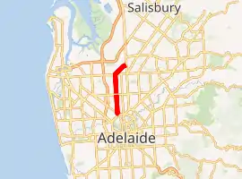
Churchill Road is an arterial road in the inner northwestern suburbs of Adelaide, Australia. Entirely designated route A22, the road commences at Torrens Road, Ovingham and travels north to Grand Junction Road (A16). Route A22 continues northeast from Grand Junction Road on Cavan Road to meet Port Wakefield Road (State route A1).
Churchill Road | |
|---|---|
| |
 N end S end | |
| Coordinates |
|
| General information | |
| Type | Road |
| Location | Adelaide |
| Route number(s) | |
| Major junctions | |
| N end | Dry Creek, Adelaide / Cavan / Gepps Cross |
| Regency Road | |
| S end | Ovingham, Adelaide |
| Location(s) | |
| LGA(s) | |
| Major suburbs | |
Churchill Road was previously known as Lower North Road.[1][2]
A22
The A22 commences at the City Ring Route (corner of Park Terrace and Fitzroy Terrace), travels northwest for a short distance along Torrens Road, then turns north into Churchill Road. It includes the complete length of Churchill Road to Grand Junction Road (A16), where it continues northeast along the complete length of Cavan Road, terminating at Port Wakefield Road (A1) in Dry Creek / Cavan / Gepps Cross.
See also
![]() Australian roads portal
Australian roads portal
References
- "Index Map" (Map). Gregory's Street Directory of Adelaide and Suburbs. 1949. Retrieved 19 May 2016 – via OSM Australia.
- "Map 35" (Map). Gregory's Street Directory of Adelaide and Suburbs. 1949. Retrieved 19 May 2016 – via OSM Australia.