Flagstaff Road, Adelaide
Flagstaff Road is an arterial road in the southern suburbs of Adelaide in South Australia, Australia. It is one of the roads that carries commuter traffic between the city on the coastal plain and residential suburbs in the Adelaide Hills.
Flagstaff Road | |
|---|---|
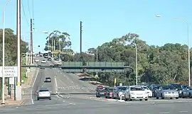 | |
Flagstaff Road from Main South Road, showing gantry lights set for two lanes uphill (southbound) | |
| |
| Coordinates |
|
| General information | |
| Type | Road |
| Length | 3.3 km (2.1 mi)[1] |
| Major junctions | |
| north end | South Road and Marion Road, Darlington |
| south end | Blacks Road and Happy Valley Drive, Flagstaff Hill |
| Location(s) | |
| LGA(s) | City of Onkaparinga |
| Restrictions | |
| General | Centre lane direction depends on time of day |
| Highway system | |
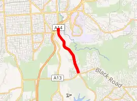
The northern end branches off of South Road at Darlington at a traffic light intersection with Marion Road opposite. Most of the road is in the suburb of Flagstaff Hill.The southern end is a roundabout where Blacks Road crosses, and Happy Valley Drive continues from Flagstaff Road in the suburb of Happy Valley. There are no major intersections along its length, only residential streets and local collectors.
The part of Flagstaff Road above the escarpment is a divided road with two lanes in each direction. The steepest section is a total of three lanes, with the middle lane reversible to match peak traffic flow. At the bottom, there are two lanes feeding into it from the traffic lights, and a total of five lanes feeding traffic towards Marion Road and South Road (northbound).
The section with three lanes was upgraded to this standard in the 1980s to address increasing traffic due to expanding suburbs such as Flagstaff Hill and Aberfoyle Park. The overhead lane direction indicators were upgraded from green arrows to white ones using newer technology in 2013[2]
The 2019 South Australian state budget allocated A$26.5 million to widen the road and remove the reversible lane.[3]
Intersections
| LGA | Location[4] | km[1] | mi | Destinations | Notes |
|---|---|---|---|---|---|
| Onkaparinga | Darlington | 0.0 | 0.0 | South Road | Continues as Marion Road |
| 0.25 | 0.16 | begin three lanes | |||
| Flagstaff Hill | 1.0 | 0.62 | Begin dual carriageway | ||
| 3.3 | 2.1 | Black Road | Continues as Happy Valley Drive | ||
| 1.000 mi = 1.609 km; 1.000 km = 0.621 mi | |||||
References
- Google (19 June 2019). "Flagstaff Road" (Map). Google Maps. Google. Retrieved 19 June 2019.
- "Traffic Signal Uprgrade for Flagstaff Hill Road, Darlington". Department of Planning, Transport and Infrastructure. 15 May 2013. Retrieved 20 June 2019.
- Slessor, Caron (18 June 2019). "SA Budget 2019: Winners and Losers". ABC News.
- "Property Location Browser" (Map). Property Location Browser. Government of South Australia. Retrieved 19 June 2019.