Salisbury Highway
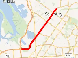
The Salisbury Highway (part of Route A9, previously Route A13 / National Highway A13) is a 12 kilometre major connecting road in the northern suburbs of the Adelaide metropolitan area.
Salisbury Highway | |
|---|---|
| |
| Coordinates |
|
| General information | |
| Type | Highway |
| Length | 12 km (7.5 mi) |
| Route number(s) | |
| Former route number |
|
| Major junctions | |
| NE end | |
| |
| SW end | |
| Location(s) | |
| Major suburbs | Salisbury, Parafield Gardens, Mawson Lakes, Dry Creek |
| Highway system | |
Salisbury Highway is dual carriageway in its entirety. It starts as Route A9 (formerly A13 until May 2017) in Elizabeth Vale as John Rice Avenue. Past the suburb of Salisbury it takes on its Salisbury Highway name. It then runs parallel to Main North Road (Route A20) and crosses over Kings Road (Route A18). At Port Wakefield Road (National Highway A1), it previously changed status to National Highway A13 (now A9 right through) before ending at the intersection of the Port River Expressway and South Road. Route A9 continues along Port River Expressway. Prior to 2017, National Highway A13 then followed South Road to Grand Junction Road (Route A16 / National Highway A16), where it changed status back to Route A13 and continued south along South Road, Main South Road and Victor Harbor Road, terminating at Victor Harbor on the south coast. The North–South Motorway is designated Route M2, and South Road continuing from it was converted to route A2 in May 2017.
Salisbury Highway was shown as part of the National Highway A13 between the Port Wakefield Road and the Port River Expressway on local road signage and major street directory publications.[1]
Until the early 1990s, Salisbury Highway terminated at Port Wakefield Road. The Salisbury Highway Extension project built the bridge and interchange at Port Wakefield Road, and extended the highway to Wingfield, where it joined the north end of what was then the South Road Interconnector. Neither the Port River Expressway nor the North–South Motorway had been built at that time.
Major intersections
| LGA[2] | Location[2][3] | km[3] | mi | Destinations | Notes |
|---|---|---|---|---|---|
| Playford | Elizabeth Vale | 0 | 0.0 | Main North Road | as John Rice Avenue |
| Elizabeth Vale, Elizabeth South | 1.8 | 1.1 | Philip Highway – Elizabeth | Roundabout | |
| City of Playford / City of Salisbury | Salisbury, Elizabeth South | 2.7 | 1.7 | Commercial Road – Edinburgh, Salisbury | John Rice Avenue northeast; Salisbury Highway southwest |
| Salisbury | Salisbury | 3.4 | 2.1 | Bridge over Little Para River | |
| 3.6 | 2.2 | Bridge under Gawler railway line and Adelaide-Port Augusta railway line | |||
| 4.0 | 2.5 |
| |||
| Salisbury Downs, Parafield Gardens | 6.2 | 3.9 | Kings Road | ||
| Mawson Lakes | 9.2 | 5.7 | Elder Smith Road – Mawson Lakes | ||
| 9.6 | 6.0 | Bridge over Dry Creek | |||
| Mawson Lakes, Dry Creek | 10.6 | 6.6 | Port Wakefield Road | Grade separated with no right turns off of Salisbury Highway | |
| Port Adelaide Enfield | Wingfield | 15.1 | 9.4 | Grade separated | |
| |||||
Gallery
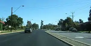 Salisbury Highway, looking southwards at Parafield Gardens.
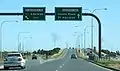 Intersection with Port Wakefield Road, looking southwards.
References
- 2006 Adelaide & Surrounds Street Directory, 54th Edition. Gregory's. ISBN 0-7319-1842-8.
- "Property Location Browser" (Map). Property Location Browser. Government of South Australia. Retrieved 8 March 2016.
- Google (8 March 2016). "Route A13 John Rice Avenue and Salisbury Highway" (Map). Google Maps. Google. Retrieved 8 March 2016.
| |||
| National Highways | |||
| M & A routes | |||
| B & C routes | |||