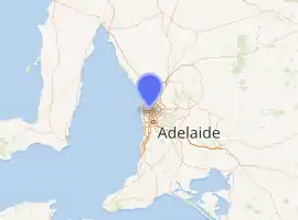
South Road, Adelaide
South Road (route A2), also known as Main South Road (routes A13 and B23), is a major north–south conduit in Adelaide and Fleurieu Peninsula in South Australia. It is one of Adelaide's most important arterial and bypass roads.
South Road Main South Road | |
|---|---|
 | |
South Road Underpass beneath the Anzac Highway | |
| |
 North end South end | |
| Coordinates |
|
| General information | |
| Type | Road |
| Length | 115 km (71 mi) |
| Route number(s) |
|
| Major junctions | |
| North end | |
Yankalilla-Victor Harbor Road | |
| South end | via Ferry to Kangaroo Island |
| Location(s) | |
| Major suburbs | Croydon, Hindmarsh, Mile End, Reynella, Morphett Vale, Old Noarlunga, Aldinga, Sellicks Hill, Yankalilla |
The northern part of South Road contributes the central component of the North–South Corridor, a series of road projects under construction or planning that will eventually provide a continuous expressway between Old Noarlunga and Gawler.
History
South Road of today was until the 1970s known by a string of names: Shillabeer Avenue (from what was then its northern terminus at Regency Road to Torrens Road), Government Road (between Torrens and Port Roads), John Street (Port to Grange Roads), Taylors Road. (between Grange and Henley Beach Roads), Fisher Terrace (Henley Beach Road to Anzac Highway), and South Road from Anzac Highway southwards.[1]
Route
South Road carries much of the road traffic from the southern suburbs towards the Adelaide city centre. This traffic completes its journey to the city centre mainly via the Anzac Highway.
From the Anzac Highway, South Road continues north as a western bypass of the city across many arterials, the major ones being Sir Donald Bradman Drive, Port Road, Torrens Road, Regency Road and Grand Junction Road, to the junction with the Port River Expressway and the Salisbury Highway. Until the Port River Expressway opened in 2005, the sections of South Road and Salisbury Highway between Grand Junction Road and Port Wakefield Road were known as the South Road Extension, built in the early 1990s.
To the south of Anzac Highway, the name changes to Main South Road at the intersection of Ayliffes and Shepherds Hill Roads at Clovelly Park, and continues through Seaford (where the Victor Harbor road branches off) and runs parallel to the coastline of Gulf St Vincent until Normanville where it is known as Willis Drive for 2 km then continues to Cape Jervis at its southern tip. The town of Old Noarlunga, South Australia was bypassed in 1972,[2] and Old Reynella in 1964.[3] The Southern Expressway (M2) runs roughly parallel to Main South Road for 18 km between Darlington and Noarlunga and serves to reduce traffic congestion. Main South Road and the Southern Expressway have 3 different intersections along the length of the roads.
Congestion and upgrades
South Road suffers from traffic congestion due to its importance as one of Adelaide's main arterial roads and bypasses. Traffic has also increased in line with the growth and development of Adelaide's southern suburbs.
Between 1982 and 1984, an overpass was built at Emerson Crossing, taking South Road over Cross Road and the Seaford railway line. For a long time, this was the only grade separation on South Road, and one of very few in South Australia, removing congestion with Cross Road traffic and the railway line. However, increasing frequency of commuter trains results in vehicle bottlenecks that are anticipated to worsen as queues on the exit ramps to Cross Road can extend into the through lanes on South Road; the rail crossing can be closed for up to 20 minutes in the peak hour.[4]:54
In November 2005, the Royal Automobile Association (RAA) released its recommendations to the South Australian government in regards to the road network. South Road was found to be the poorest road in the state, registering a 2/10 on the RAA's scale. The recommendations given included $6 billion of funds to upgrade the roads of South Australia – with $1.5–2 billion to be spent on South Road alone. The RAA's plan for the road included a 6 km tunnel from Port Road all the way to the Anzac Highway underpass and over/underpasses at six other major intersections and two rail crossings.[5]

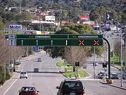
In 2005, along with the decision to make a free flowing South Road, a decision was made to build an underpass for South Road to go under Anzac Highway. Named the Gallipoli Underpass in line with the ANZAC theme, construction started in 2007 and the underpass opened in March 2009. To cut down on delays due to construction, an overpass was also built within the same time frame for the Glenelg tram line just half a kilometre to the south, which also opened in 2009, significantly removing delays from this area.
On 18 August 2007, Prime Minister John Howard announced that South Road was to be included in the AusLink National Road Network, and also pledged $1 billion in funding for the project between 2007 and 2020.[6]
North–South Motorway
The North–South Motorway is an incomplete motorway intended to replace South Road as Adelaide's primary north-south roadway. Running along the same road corridor as South Road and extending further north, the motorway has been progressively constructed in stages and as of November 2020, approximately 22 km of the total 35 km length has been completed.
The first section of the motorway, known as the South Road Superway, was announced in October 2009 and constituted 3–4 km of elevated motorway running from the Port River Expressway to the intersection with Regency Road. The project started in 2010 and was completed in early 2014. Following the 2013 Australian federal election, the section of South Road between Torrens Road and the River Torrens was identified and funded for upgrade which would see a 4 km lowered motorway constructed between the northbound and southbound lanes of South Road. The Darlington Upgrade, an extension of the Southern Expressway through Bedford Park by use of a similar lowered motorway concept, was also identified at this time. Both of these upgrades involved land acquisition to widen the road corridor, surface grade carriage ways on the edges, and a lowered central roadway carrying the free-flow traffic below the crossing routes. The Torrens to Torrens lowered motorway started construction in 2015,[7] and opened to traffic in 2018;[8] the Darlington Upgrade began construction in 2016 and was opened in 2020.[9]
An upgrade of Regency Road to Pym Street, the gap between the elevated South Road Superway and the (then) almost-completed Torrens to Torrens lowered motorway, was announced on 1 May 2018, to be jointly funded by the state and federal governments.[10] This section began construction in 2019 with expected completion in 2022.[11] Preliminary plans for the final section stretching from the River Torrens to Darlington, which would use a combination of deep-bored tunnels, lowered motorway and surface-level motorway, were announced in late 2020 and are still under investigation.[12]
Major intersections (north–south)
Gallery
 Looking south from the Cross Road Overpass, Edwardstown.
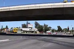 South Road overpass at Cross Road / Emerson Station.
See also
References
- Sands and McDougall's Directory, 1962.
- Old Noarlunga
- Local Studies. Former Cricketers-Retrieved 24/01/2012
- "North–South Corridor The 10 year Strategy" (PDF). Department of Planning, Transport and Infrastructure. May 2015. K-Net #9526649, V1. Archived from the original (PDF) on 21 March 2016. Retrieved 6 April 2016.
- PDF Archived 15 January 2009 at the Wayback Machine
- Media Releases Archived 29 August 2007 at the Wayback Machine
- "North-South Corridor: Torrens Road to River Torrens". Department of Planning, Transport and Infrastructure, Government of South Australia. 5 August 2015. 145594. Retrieved 8 August 2015.
- "T2T". T2T Alliance. 31 July 2015. Retrieved 8 August 2015.
- "Darlington Upgrade Project". Department of Planning, Transport and Infrastructure, Government of South Australia. Retrieved 14 December 2019.
- "Regency Road to Pym Street". Department of Planning, Transport and Infrastructure, Government of South Australia. Retrieved 22 August 2018.
- Tudge, Alan; Knoll, Stephan (5 July 2019). "Building Regency to Pym to begin this year" (PDF) (Press release). Retrieved 14 December 2019.
- "Budget 2020: The key measures". InDaily. 10 November 2020. Archived from the original on 10 November 2020.
- "Property Location Browser". Department of Planning, Transport and Infrastructure, Government of South Australia. Retrieved 21 May 2015.
- Google (21 May 2015). "South Road, Adelaide" (Map). Google Maps. Google. Retrieved 21 May 2015.
- Outer Harbor Rail Overpass & Temporary South Road Closure T2T Alliance
- "Road Route Numbers (Trail Blazer)". Data SA. Government of South Australia. 8 November 2016. Retrieved 18 October 2017.
- "Glenelg Tram Overpass". South Australian Department for Transport, Energy and Infrastructure. 19 June 2008. Retrieved 28 March 2009.
- "BUDGET: Transport infrastructure investment". Premier & Ministers of South Australia. 21 September 2006. Archived from the original on 27 July 2008. Retrieved 28 March 2009.
Road infrastructure in South Australia | ||
|---|---|---|
| Expressways |
| |
| Interstate highways | ||
| State highways | ||
| Arterial roads |
| |
| Outback tracks | ||
| |||
| National Highways | |||
| M & A routes | |||
| B & C routes | |||