Clarendon Parish, New Brunswick
Clarendon is a civil parish in Charlotte County, New Brunswick, Canada,[2] located in the interior to the north of Point Lepreau and southwest of CFB Gagetown.
Clarendon Parish
Paroisse de Clarendon | |
|---|---|
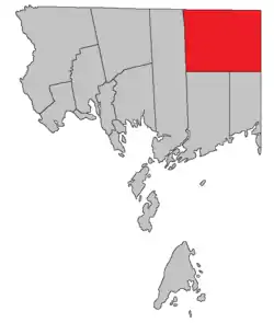 Location within Charlotte County. | |
| Country | |
| Province | |
| County | Charlotte County |
| Erected | 1869 |
| Named for | George Villiers, 4th Earl of Clarendon |
| Government | |
| • Type | Local service district |
| Area | |
| • Land | 492.19 km2 (190.04 sq mi) |
| Population (2016)[1] | |
| • Total | 63 |
| • Density | 0.1/km2 (0.3/sq mi) |
| • Change 2011-2016 | |
| • Dwellings | 90 |
| Time zone | UTC-4 (AST) |
| • Summer (DST) | UTC-3 (ADT) |
The local service district (LSD) and Census subdivision of the same name have the same boundaries as the parish.[3]
The LSD assesses for assesses for community & recreation services[4] in addition to basic LSD services;[lower-alpha 1] all services except fire protection are administered by Regional Service Commission 11.
Origin of name
The parish was named for Clarendon Settlement, which in turn was named for the Earl of Clarendon, British Secretary of State for Foreign Affairs at the time.[5]
History
Clarendon was erected in 1869 from Lepreau and Pennfield Parishes.[6]
The area was first laid out for settlement in 1856,[7] with the Clarendon Settlement being largest. Much of the parish was never surveyed for settlement, most of the surveyed lots were never granted, and many granted lots were later reconveyed to the Crown.[8]
In 1868 the Clarendon District was created as a polling district taking in the northern part of Lepreau and Pennfield Parishes.[9]
Boundaries
Clarendon Parish has very regular boundaries: on the east by Queens County, on the south by a due west line from the southernmost corner of Queens County, on the north by the county line, and on the west by the prolongation of the rear line of grants along Lake Utopia in Saint George Parish.[2]
Bodies of water
Bodies of water at least partly within the parish;[10][11][12][13][14] italics indicate a deprecated name.[lower-alpha 2] There are more than thirty officially named lakes within the parish, only some of which are listed below.
|
|
|
|
Islands
Islands within the parish.[11]
- Bradt Island (in McDougall Lake)
- Horse Island (in South Oromocto Lake)
Conservation areas
Parks, historic sites, and related entities in the parish.[11][12][13][14]
- Lepreau River Wildlife Management Area
- Little Tomoowa Lake Protected Natural Area
Demographics
Population
| Canada census – Clarendon Parish, New Brunswick community profile | |||
|---|---|---|---|
| 2016 | 2011 | 2006 | |
| Population: | 63 (+21.2% from 2011) | 52 (-26.8% from 2006) | 71 (+73.2% from 2001) |
| Land area: | 492.19 km2 (190.04 sq mi) | 492.91 km2 (190.31 sq mi) | 492.84 km2 (190.29 sq mi) |
| Population density: | 0.1/km2 (0.26/sq mi) | 0.1/km2 (0.26/sq mi) | 0.1/km2 (0.26/sq mi) |
| Median age: | 59.2 (M: 59.8, F: 57.7) | 58.0 (M: 59.5, F: 56.5) | 48.8 (M: 50.0, F: 47.8) |
| Total private dwellings: | 90 | 76 | 64 |
| Median household income: | $44,928 | $.N/A | $.N/A |
| Notes: Income data for this area has been suppressed for data quality or confidentiality reasons. – References: 2016[15] 2011[16] 2006[17] earlier[18] | |||
|
|
| |||||||||||||||||||||||||||
| [19][1] | |||||||||||||||||||||||||||||
Language
| Canada Census Mother Tongue - Clarendon Parish, New Brunswick[19] 2001 & 2006 language data for this area has been suppressed for data quality or confidentiality reasons. | ||||||||||||||||||
|---|---|---|---|---|---|---|---|---|---|---|---|---|---|---|---|---|---|---|
| Census | Total | French |
English |
French & English |
Other | |||||||||||||
| Year | Responses | Count | Trend | Pop % | Count | Trend | Pop % | Count | Trend | Pop % | Count | Trend | Pop % | |||||
2011 |
50 |
50 | 100.00% | 0 | 0.00% | 0 | 0.00% | 0 | 0.00% | |||||||||
1996 |
50 |
50 | n/a | 100.00% | 0 | n/a | 0.00% | 0 | n/a | 0.00% | 0 | n/a | 0.00% | |||||
Access Routes
Highways and numbered routes that run through the parish, including external routes that start or finish at the parish limits:[20]
See also
Notes
- Firefighting, policing, zoning, EMO, and dog control, along with administrative costs;
- Categorised as Historical rather than Official by the Canadian Geographic Name Service; only those significantly different from modern names are noted.
- Name does not appear in CGNS data but is on the map of the Protected Natural Area.
References
- "Census Profile, 2016 Census: Clarendon, Parish [Census subdivision], New Brunswick". Statistics Canada. Retrieved 8 September 2019.
- "Chapter T-3 Territorial Division Act". Government of New Brunswick. Retrieved 1 August 2020.
- "New Brunswick Regulation 84-168 under the Municipalities Act (O.C. 84-582)". Government of New Brunswick. Retrieved 1 August 2020.
- "2019 Local Government Statistics for New Brunswick" (PDF). Department of Environment and Local Government. p. 59. Retrieved 2 August 2020.
- Ganong, William F. (1896). A Monograph of the Place-Nomenclature of the Province of New Brunswick. Royal Society of Canada. p. 227.
- "32 Vic. c. 51 An Act to erect part of the Parishes of Lepreaux and Pennfield, in the County of Charlotte, into a separate Town or Parish.". Acts of the General Assembly of Her Majesty's Province of New Brunswick. Passed in the Month of April 1869. Fredericton: Government of New Brunswick. 1869. pp. 96–97.
- Ganong, p. 208
- "No. 155". Provincial Archives of New Brunswick. Department of Natural Resources and Energy Development. Retrieved 13 November 2020.
- "31 Vic. c. 51 An Act to establish an additional Polling place in the County of Charlotte.". Acts of the General Assembly of Her Majesty's Province of New Brunswick. Passed in the Month of March 1868. Fredericton: Government of New Brunswick. 1868. p. 84.
- "untitled spreadsheet of New Brunswick place names". Geographical names in Canada. Natural Resources Canada. Retrieved 20 July 2020.
- "No. 155". Provincial Archives of New Brunswick. Department of Natural Resources and Energy Development. Retrieved 20 October 2020.
- "No. 156". Provincial Archives of New Brunswick. Department of Natural Resources and Energy Development. Retrieved 20 October 2020.
- "No. 162". Provincial Archives of New Brunswick. Department of Natural Resources and Energy Development. Retrieved 20 October 2020.
- "No. 163". Provincial Archives of New Brunswick. Department of Natural Resources and Energy Development. Retrieved 20 October 2020.
- "2016 Community Profiles". 2016 Canadian Census. Statistics Canada. 21 February 2017. Retrieved 8 September 2019.
- "2011 Community Profiles". 2011 Canadian Census. Statistics Canada. 5 July 2013. Retrieved 15 March 2014.
- "2006 Community Profiles". 2006 Canadian Census. Statistics Canada. 30 March 2011. Retrieved 15 March 2014.
- "2001 Community Profiles". 2001 Canadian Census. Statistics Canada. 17 February 2012.
- Statistics Canada: 1996, 2001, 2006, 2011 census
- Atlantic Canada Back Road Atlas ISBN 978-1-55368-618-7 Pages 4, 12
Places adjacent to Clarendon Parish, New Brunswick | |
|---|---|
| Subdivisions | |
|---|---|
| Cities | |
| Counties | |
| |