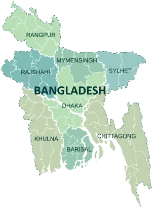
Comilla District
Comilla District , officially known as Cumilla District[3] It is a district of Bangladesh located about 100 kilometres south east of Dhaka. Comilla is bordered by Brahmanbaria and Narayanganj districts to the north, Noakhali and Feni districts to the south, Tripura of India to the east and Munshiganj and Chandpur districts to the west. Comilla district is located in the south eastern part of Bangladesh.[4]
Comilla
কুমিল্লা জেলা | |
|---|---|
| Cumilla | |
 Location of Comilla within Bangladesh | |

Expandable map of Comilla | |
| Coordinates: 23.27°N 91.12°E | |
| Country | |
| Division | Chittagong Division |
| Capital | Comilla |
| Government | |
| • Deputy Commissioner | Md. Abul Fazal Mir |
| Area | |
| • Total | 3,146.30 km2 (1,214.79 sq mi) |
| Population (2011 census)[1] | |
| • Total | 5,387,288 |
| • Density | 1,700/km2 (4,400/sq mi) |
| Time zone | UTC+06:00 (BST) |
| HDI (2018) | 0.614[2] medium · 7th of 21 |
| Notable sport teams | Comilla Victorians |
History
The name Cumilla is derived from the Bengali word Komolangko (Bengali: কমলাঙ্ক), the previous ancient name of the region, which means the pond of lotus. The present Comilla is a district under the Chittagong Division. It was once under ancient Samatata and later became part of the state of Tripura. As far as is known from the ancient archeology found in the region, Gupta emperors ruled Tripura since the fifth century AD. According to historians, the Buddhist Deva dynasty ruled the region from the seventh to the middle of the eighth century. In the ninth century, Comilla came under the control of the kings of Harikela and then ruled by the Chandra dynasty during the tenth and mid-eleventh century AD. Later on, it was ruled by the Mughals and then it came under the rule of East India Company in 1765. In order to facilitate revenue collection, the company hired a district collector in the province in 1769. Comilla then belonged to the province of Dhaka. Comilla was made under the office of the district collector in 1776. The Tripura Collector's journey began with the formation of Tippera or Tipperah district of Bengal by the British in 1790.[5] According to the Third Regulation in 1793, a civil judge was appointed for the Tripura district and in that year he was given magisterial powers. In 1837, the posts of magistrates and collectors were separated. In 1859, these two posts were merged again. After the partition in 1947, the district was renamed Comilla in 1960 and the post of district magistrate and collector was named deputy commissioner.[6] Chandpur and Brahmanbaria sub-divisions of this district were transformed into districts in 1984.
Geography and climate
Comilla has a total area of 3085.17 square kilometres. It is bounded by Burichang and Tripura on the north, Laksham and Chauddagram on the south, and Barura on the west. Major rivers passing through Comilla include the Gumti and the Little Feni. It is hot in summer and cold in winter.[4]
Administration
The administrative headquarters of Comilla are located in the city of Comilla which has a total area of 11.47 square kilometres. It consists of 18 mouzas and 3 wards. Comilla thana was officially converted into an upazila in 1983 which contains one municipality 18 wards, 19 union parishads, 452 mouzas, and 458 villages.[4]
Administrator of Zila Parishad: M. Omar Faruque[7]
Deputy Commissioner (DC): Md Jahangir Alam[8]
Subdistricts
Comilla district consists of the following Upazilas:[9]
- Barura Upazila
- Brahmanpara Upazila
- Burichong Upazila
- Comilla Sadar Upazila
- Comilla Sadar Dakshin Upazila
- Chandina Upazila
- Chauddagram Upazila
- Daudkandi Upazila
- Debidwar Upazila
- Homna Upazila
- Laksam Upazila
- Lalmai Upazila
- Monohorgonj Upazila
- Meghna Upazila
- Muradnagar Upazila
- Nangalkot Upazila
- Titas Upazila
Economy
Mainly based on agriculture, the economy of Comilla has flourished through trade and cottage industries, especially the 'Khadi' textile. For the economic development of the region the "Bangladesh Export Processing Zone Authority" has established the "Comilla Export Processing Zone" spread over an area of 104.44 hectares (258.1 acres) in the Comilla Airport area in 2000.[10] The export zone employs 20 thousand people as of 2013.[11]
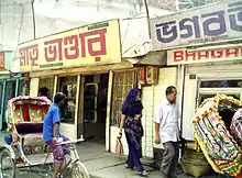
Places of interest
.jpg.webp)
Important landmarks include Kotbari, a cantonment, or military installation and Kandirpar, considered the heart of the Comilla district. Ancient Buddhist monastery ruins are the major attraction of Mainamati, near Kotbari. There is an ancient Hindu Temple named Comilla Jagannath Temple located on East Bibirbazar Road. There is also the recently constructed Allah Chattar, a tower in Muradnagar.
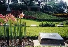
There is a Second World War cemetery, Mainamati War Cemetery, located about 3.1 kilometres (1.9 mi) away from Comilla Cantonment, which was a frontier military base in the fight against the Japanese who had occupied Burma. British Army soldiers killed during the fight with the Japanese Army at the Burma (Myanmar) frontier were buried here.[12] Pashchimgaon Nawab Bari, the place of only lady Jaminder Nawab Faizunnesa, a poet, educationist and a philanthropist.[13]
Kazi Nazrul Islam, the national poet of Bangladesh, passed a significant time of his life in this town. Both his wives, Promila Devi and Nargis, hailed from this district.[14]
Comilla Victoria College and Comilla Zilla School are two old and renowned college and school in the country. Comilla Zilla School was established in the year of 1837.[15] Bangladesh Academy for Rural Development (BARD) is situated in Kotbari. The area also saw the development of Comilla Model.[16]
Education
- Board of Intermediate and Secondary Education, Comilla
- Comilla University
- Comilla Medical College
- Comilla Victoria Government College
- Bangladesh Army International University of Science & Technology
- Ispahani Public School & College, Comilla
- Comilla Polytechnic Institute, Comilla
- Comilla Government College
- Comilla Government Women's College
- Comilla Cadet College
- Comilla Zilla School
- Bangladesh Survey Institute
- List of Educational Institutions in Comilla
Notable people
The following personalities were either born or stayed in this district for a significant span of their lifetime:
- Nawab Faizunnesa Choudhurani (1834–1903): poet and philanthropist.
- Kazi Zafar Ahmed: former Prime Minister
- Shilvadra (529–654): a great Buddhist monk and pundit, professor and chancellor of Nalanda University. Born in Koilain, Chandina Upazila
- Dhirendranath Datta (1886–1971): political leader, provincial minister of the than East Pakistan, Language Movement activist and lawyer.
- Buddhadeb Basu (1908–1974): Bengali poet, novelist, essayist, translator & editor.
- Sachin Dev Burman (1906–1975): singer, composer & music director.
- Akhtar Hameed Khan (1914–1999): social reformer and development activist. He is from U.P -undivided India, but spent an important part of his life as asst magistrate (ICS) and thereafter as principal Victoria College and creator of co-operative programme and BARD at Comilla.
- Shib Narayan Das: The designer of the first national flag of Bangladesh in 1971, a freedom fighter and political activist
- Kamrul Ahsan : secretary to the government and now serving as Bangladesh Ambassador to Russia. Earlier served as High Commissioner to Canada and Singapore.
- Sabitri Chatterjee: actress in Indian Bengali film, TV serial and theatre.
- Akbar Hossain BP: former minister of Bangladesh Government.
- Kazi Shamsul Hoque eminent journalist, founder editor of weekly Akhon Samoy, New York.
- Abdul Gani: (1919 – 1957) was a Bengali military officer. He was the founder and the first in-charge of one of the pioneer companies of 1st East Bengal Regiment.
- Abul Manzoor, sector commander during Bangladesh War of Independence and decorated with the award Bir Uttom, was born in Comilla.
- Sudhin Das, Swaralipikar of Nazrul Sangeet, awarded by Ekushe Padak
- Alaka Das, artist of classical music, principal of Sangeet Shikhharthee Sammilan (সঙ্গীত শিক্ষার্থী সম্মেলন)[17] Talpukur Par, Comilla
- Sagarmoy Ghosh : Bengali editor and author
- General Iqbal Karim Bhuiyan : former chief of Army Staff
- Atiqul Islam - Mayor, Dhaka North City Corporation
- Md Mainul Islam - former chief, Border Guards Bangladesh
- Md. Tafazzul Islam - 17th Chief Justice of Bangladesh.[18]
- Ferdous Ahmed - Bangladeshi film actor.
- Khondaker Mostaq Ahmad, 5th President of Bangladesh (15 August 1975 to 3 November 1975).[19]
See also
- List of Educational Institutions in Comilla
References
- "Population and Housing Census 2011" (PDF). Archived from the original (PDF) on 15 January 2013.
- "Sub-national HDI - Area Database - Global Data Lab". hdi.globaldatalab.org. Retrieved 18 March 2020.
- Mahadi Al Hasnat (2 April 2018). "Mixed reactions as govt changes English spellings of 5 district names". Dhaka Tribune. Retrieved 8 April 2018.
- Siddiqi, Mamun (2012). "Comilla District". In Islam, Sirajul; Jamal, Ahmed A. (eds.). Banglapedia: National Encyclopedia of Bangladesh (Second ed.). Asiatic Society of Bangladesh.
- "Bengal District Gazetteer Tipperah District".
- "Cumilla District background".
- "AL men appointed administrators". The Daily Star. 16 December 2011. Retrieved 19 September 2017.
- "Outcry over Comilla DC's misbehaviour with journos". Dhaka Tribune. Retrieved 20 September 2017.
- Upazilas of Comilla Archived 24 November 2007 at the Wayback Machine. Bangladesh Government.
- "Profile Of Zone Comilla | Comilla EPZ". www.bepza.gov.bd. Retrieved 20 September 2017.
- "9 new units to start production in Comilla EPZ soon". Dhaka Tribune. Archived from the original on 20 September 2017. Retrieved 20 September 2017.
- "Tributes paid at Maynamati War Cemetery". Dhaka Tribune. Retrieved 20 September 2017.
- "Choudhurani, Nawab Faizunnesa". Banglapedia. Retrieved 20 September 2017.
- "Islam, Kazi Nazrul". Banglapedia. Archived from the original on 6 July 2017. Retrieved 20 September 2017.
- "Comilla Zila School". Banglapedia. Retrieved 20 September 2017.
- Binswanger-Mkhize, Hans P.; Regt, Jacomina P. de; Spector, Stephen (12 February 2010). Local and Community Driven Development: Moving to Scale in Theory and Practice. World Bank Publications. p. 32. ISBN 9780821381953.
- http://www.comillarkagoj.com/2016/05/29/23242.php
- "Life sketch of newly appointed Chief Justice of Bangladesh". Bangladesh Sangbad Sangstha. 23 December 2009. Archived from the original on 4 March 2016.
- Khan, Saleh Athar (2012). "Ahmad, Khondakar Mostaq". In Islam, Sirajul; Jamal, Ahmed A. (eds.). Banglapedia: National Encyclopedia of Bangladesh (Second ed.). Asiatic Society of Bangladesh.
External links
| Wikimedia Commons has media related to Cumilla District. |