Rajbari District
Rajbari (Bengali: রাজবাড়ি is a district in central Bangladesh, located in the Dhaka Division.[1][3] It is a part of the Greater Faridpur subregion of Bengal due to the historical, linguistic and cultural identities of its inhabitants.
Rajbari District
রাজবাড়ী জেলা | |
|---|---|
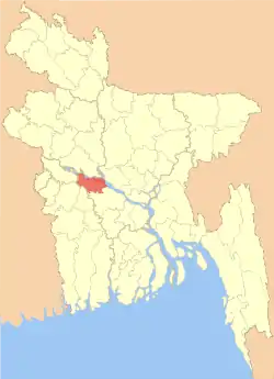 Location of Rajbari District in Bangladesh | |

Expandable map of Rajbari District | |
| Coordinates: 23.70°N 89.50°E | |
| Country | |
| Division | Dhaka Division |
| Government | |
| • Deputy Commissioner | Dilsad Begum |
| • District Chairman | Faqir Abdul Jabbar |
| • MP (Rajbari-1) | Kazi Keramat Ali |
| • MP (Rajbari-2) | Zillu Hakim |
| Area | |
| • Total | 1,118.8 km2 (432.0 sq mi) |
| Population (2011 census) | |
| • Total | 1,049,778 |
| • Density | 940/km2 (2,400/sq mi) |
| Literacy rate | |
| • Total | 39.81%[1] |
| Time zone | UTC+06:00 (BST) |
| Postal code | 7700 |
| HDI (2018) | 0.596[2] medium · 11th of 21 |
| Website | www |
History
During the reign of Mughal emperor Jahangir, a fief in Padamdi was decreed to the family of an Iraqi Muslim immigrant by the name of Syed Shah Pahlwan in 1607. The zamindari family, known as the Nawabs of Padamdi actively commanded the artillery and served the Mughal army, eventually leading to Emperor Shah Jahan bestowing them the title of Mir.
Rajbari in the Bengali language means palace, and pays homage to the rich zamindari families that feudally ruled modern-day Rajbari. In the 17th century, the Mughal governor of Bengal, Shaista Khan, appointed Sangram Shah of Panchthupi as the Nawara of what is present-day Rajbari in order to suppress the Portuguese pirates. The Nawara settled permanently in the populated neighbourhood of Banibaha and built a fort at a place called Lalgola. Sangram Shah and his family later became known as the Nawara Chowdhuries of Banibaha.
After the Battle of Plassey of 1757, one of Siraj ud-Daulah's officers by the name of Prabhuram went into hiding in Lakshmikol to avoid the British colonialists. Prabhuram's son, Dwigendra Prasad, eventually became a prominent zamindar in the area, and his son Surya Kumar earned the title of Raja. In 1890, the Rajbari railway station was established, and it is said that it was named after Raja Surya Kumar. Other zamindars such as the Nawara Chowdhuries of Banibaha objected to this as the name of Rajbari was said to have been established long before Kumar.[4]
During the Bangladesh Liberation War of 1971, an organisation named the Sangram Parishad (Struggle Council) was established on 26 March. On 21 and 22 April, six Bengali freedom fighters were murdered during an encounter with the Pakistan Army. In the villages of Majhpara, Ramcole and Mathurapur, the army murdered 10 people in addition to setting many houses on fire. The Bengali freedom fighters captured a large amount of equipment and resources from the Army in November. Another brawl took place in that month in the village of Alhadipur leading to 9 Army casualties.[1]
Administration
Once Rajbari region was a part of Jessore District. In 1811 when Faridpur District was formed Rajbari was included in it. Besides, the upazilas under Rajbari district were included in different districts in the past. Pangsha Upazila was once included into Pabna District. In 1859 Pangsha and Baliakandi were included in the newly formed Kumarkhali Upazila. In 1871, when Goalanda Upazila was formed, Pangsha and Rajbari were included in it and its headquarters was established in Rajbari. Goalanda was upgraded into a district in March 1984 and it was renamed as Rajbari District.[1]
Upazilas
Deputy Commissioner
The DC is the chief administrative and revenue officer of Rajbari District.
| Name | Term |
|---|---|
| Shahiduddin Ahmad | 26/2/1984 - 5/10/1986 |
| Muhammad Najmul Ahsan | 29/9/1986 - 25/2/1989 |
| Zillur Rashid Chowdhury | 22/2/1989 - 8/1/1991 |
| Chowdhury Ghulam Mawla | 13/8/1992 - 1/8/1995 |
| Muhammad Wahidur Rahman | 2/8/1995 - 21/8/1995 |
| AFM Matiur Rahman | 22/8/1995 - 27/4/1996 |
| Amirul Karim | 22/4/1996 - 14/7/1999 |
| ASM Hanifuddin Sarkar | 15/7/1999 - 28/3/2001 |
| Raziyah Begum | 28/3/2001 - 25/4/2002 |
| Bijankanti Sarkar | 25/4/2002 - 1/9/2004 |
| Muhammad Nurul Alam | 1/9/2004 - 3/9/2006 |
| Muhammad Jamal Husayn Majumdar | 3/9/2006 - 19/11/2006 |
| Tawhidah Bulbul | 19/11/2006 - 26/1/2008 |
| Muhammad Mahfuzur Rahman | 24/1/2008 - 28/4/2009 |
| Fayz Ahmad | 27/4/2009 - 27/4/2010 |
| Sayyidah Sahana Bibi | 27/4/2010 - 12/12/2012 |
| Muhammad Hasanuzzaman Kallol | 12/12/2012 - 20/6/2014 |
| Muhammad Rafiqul Islam Khan | 20/6/2014 -2/2/2016 |
| Jinnat Ara | 2/2/2016 - 11/5/2017 |
| Muhammad Shawqat Ali | 11/5/2017 - 24/6/2019 |
| Dilshad Begum | Present |
Education
Schools
- Rajbari Government High School (also known as Rajbari Zilla School and previously as Goalondo High School)
- Rajbari Government Girls High School
- R.S.K Institution ( It was established in 1888 by the name of Raja Surja Kumar )
- Rajdharpur Madhyamik Bidyalay
- Baharpur High School
- Kola Sadar Uddin High School
- Atdapunia High School
- Mulghor High School
- Kashbamajail A.H High School
- Suraj Mohini Institute & Tamijuddin Girls High School
- Mohonpur K.B. Academy
Colleges
- Rajbari Government College, Rajbari [6]
- Rajbari Government Adarsha Mohila College
- Dr. Abul Hossain University College
- Pangsha Government College
- Baharpur College
- Baliakandi Degree Collage
- Mansur Ali Degree College
- Mir Mosharraf Hossain Degree College
- Jamalpur Degree College
There are also so many Institute which are popularly known by the People.
Geography and climate
Annual average temperature of this district is maximum 35.8 °C and minimum 12.6 °C. Annual rainfall is 2105 mm.
Religion
The district is predominately Muslim. There are Muslim 847616, Hindu 103664, Buddhist 173 and others 453.[1]
Places of interest
Podamdi and Kurshi are also known for Nawaabs which was originally the subedar (provincial governor) or viceroy of a subah (province) or region of the Mughal empire. It became a high title for Muslim nobles.
Dighi (a kind of water body) in Rajbari include Kallyan Dighi, situated in Baliakandi of Islampur union. Rajbari is situated by the bank of Padma River.
'Godar Bazar' bank of Padma River near at Rajbari town.
Notable people
- AKM Aszad, politician
- Ali Newaz Mahmud Khaiyam, former MP
- Jahanara Begum, politician
- Kazi Abdul Wadud, dramatist
- Maulvi Tamizuddin Khan, former Speaker of the Constituent Assembly of Pakistan
- Md. Abdul Wajed Chowdhury, politician
- Monsur Ul Karim, painter
- Padamdi Zamindar family
- Mir Mosharraf Hossain, novelist and playwright
- Syed Mir Ali Imam Al Mamun, former Bangladesh Army officer
- Qazi Motahar Hossain, scientist, author and teacher
- Rowshan Ali Chowdhury, journalist
- Yakub Ali Chowdhury, essayist
- Salma Chowdhury, MP
- Shohely Akhter, cricketer
- Satish Chandra Vidyabhusan, eminent Sanskrit scholar
See also
References
| Wikimedia Commons has media related to Rajbari District. |
- BM Rezaul Karim (2012). "Rajbari District". In Islam, Sirajul; Miah, Sajahan; Khanam, Mahfuza; Ahmed, Sabbir (eds.). Banglapedia: the National Encyclopedia of Bangladesh (Online ed.). Dhaka, Bangladesh: Banglapedia Trust, Asiatic Society of Bangladesh. ISBN 984-32-0576-6. OCLC 52727562. Retrieved 9 February 2021.
- "Sub-national HDI - Area Database - Global Data Lab". hdi.globaldatalab.org. Retrieved 2020-03-18.
- "Rajbari District Information". Retrieved 6 January 2013.
- "জেলার পটভূমি" [Background of the District]. Rajbari Jela (in Bengali).
- AL men appointed administrators
- Rajbari district information