Cornish, New Hampshire
Cornish is a town in Sullivan County, New Hampshire, United States. The population was 1,640 at the 2010 census.[1] Cornish has four covered bridges. Each August, it is home to the Cornish Fair.
Cornish, New Hampshire | |
|---|---|
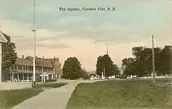 The Square in 1917 | |
 Location in Sullivan County and the state of New Hampshire. | |
| Coordinates: 43°27′53″N 72°22′09″W | |
| Country | United States |
| State | New Hampshire |
| County | Sullivan |
| Incorporated | 1765 |
| Villages | Cornish Center Cornish City Cornish Flat Cornish Mills Balloch South Cornish |
| Government | |
| • Board of Selectmen | John Hammond, Chair Scott Baker Lyle Parry |
| Area | |
| • Total | 42.8 sq mi (111.0 km2) |
| • Land | 42.1 sq mi (109.1 km2) |
| • Water | 0.7 sq mi (1.9 km2) 1.68% |
| Elevation | 466 ft (142 m) |
| Population (2010) | |
| • Total | 1,640 |
| • Density | 38/sq mi (15/km2) |
| Time zone | UTC−5 (Eastern) |
| • Summer (DST) | UTC−4 (Eastern) |
| ZIP Codes | 03745 (Cornish) 03746 (Cornish Flat) |
| Area code(s) | 603 |
| FIPS code | 33-15060 |
| GNIS feature ID | 0873571 |
| Website | www |
History
The town was granted in 1763 and contained an area once known as "Mast Camp" because it was the shipping point for the tall masts floated down the river by English settlers. It was incorporated in 1765 by Colonial Governor Benning Wentworth and named for Sir Samuel Cornish, a distinguished admiral of the Royal Navy.[2]
Since the late 19th century, Cornish has been a well-known summer resort for artists and writers. Sculptor Augustus Saint-Gaudens began coming to Cornish in 1885, seeking a studio away from the summer heat of New York City. Artist friends followed him, including painter and illustrator Maxfield Parrish, who designed and built his estate, the Oaks, in the area. The surrounding area became the center of the popular Cornish Art Colony.[3] Cornish was the residence of the reclusive author J. D. Salinger, from the 1950s until his death in 2010.
Cornish is the site of the longest wooden covered bridge in the United States, and the longest two-span covered bridge in the world. The Cornish-Windsor Covered Bridge spans the Connecticut River and was built in 1866 at an original cost of $9,000. Cornish also has three other covered bridges: the Blow-Me-Down Covered Bridge, Dingleton Hill Covered Bridge, and Kenyon Bridge.
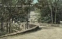 Blow-me-down Bridge in 1908, completed in 1888
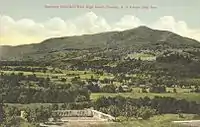 Mount Ascutney from "High Court" estate c. 1910
Geography
According to the United States Census Bureau, the town has a total area of 42.8 square miles (111 km2), of which 42.1 sq mi (109 km2) is land and 0.7 sq mi (1.8 km2) is water, comprising 1.68% of the town. The long ridge of Croydon Mountain follows the eastern boundary of town; the highest point in town is a knob on Croydon Mountain which reaches an elevation of 2,323 ft (708 m) above sea level.[4] Cornish is drained by Mill Brook, Blow-me-down Brook, and the Connecticut River, which bounds it on the west. Cornish lies fully within the Connecticut River watershed.[5] The eastern part of the town is a portion of the approximately 25,000-acre (100 km2) Blue Mountain Forest Association private game preserve, also known locally as Corbin Park, named after its founder, Austin Corbin.
Cornish is dotted with several small villages, including Cornish Center, Cornish Flat, Cornish City, Cornish Mills, South Cornish, Balloch, and Squag City.
Adjacent municipalities
- Plainfield, New Hampshire (north)
- Croydon, New Hampshire (east)
- Claremont, New Hampshire (south)
- Windsor, Vermont (west)
Demographics
| Historical population | |||
|---|---|---|---|
| Census | Pop. | %± | |
| 1790 | 982 | — | |
| 1800 | 1,268 | 29.1% | |
| 1810 | 1,606 | 26.7% | |
| 1820 | 1,701 | 5.9% | |
| 1830 | 1,687 | −0.8% | |
| 1840 | 1,726 | 2.3% | |
| 1850 | 1,606 | −7.0% | |
| 1860 | 1,520 | −5.4% | |
| 1870 | 1,334 | −12.2% | |
| 1880 | 1,156 | −13.3% | |
| 1890 | 954 | −17.5% | |
| 1900 | 962 | 0.8% | |
| 1910 | 1,005 | 4.5% | |
| 1920 | 844 | −16.0% | |
| 1930 | 855 | 1.3% | |
| 1940 | 790 | −7.6% | |
| 1950 | 989 | 25.2% | |
| 1960 | 1,106 | 11.8% | |
| 1970 | 1,268 | 14.6% | |
| 1980 | 1,390 | 9.6% | |
| 1990 | 1,659 | 19.4% | |
| 2000 | 1,661 | 0.1% | |
| 2010 | 1,640 | −1.3% | |
| 2017 (est.) | 1,624 | [6] | −1.0% |
| U.S. Decennial Census[7] | |||
As of the census[8] of 2000, there were 1,661 people, 645 households, and 465 families residing in the town. The population density was 39.4 people per square mile (15.2/km2). There were 697 housing units at an average density of 16.5 per square mile (6.4/km2). The racial makeup of the town was 97.71% White, 0.30% African American, 0.30% Native American, 0.12% Asian, 0.12% Pacific Islander, 0.30% from other races, and 1.14% from two or more races. Hispanic or Latino of any race were 0.48% of the population.
There were 645 households, out of which 32.2% had children under the age of 18 living with them, 62.9% were married couples living together, 5.4% had a female householder with no husband present, and 27.8% were non-families. Of all households 21.2% were made up of individuals, and 7.4% had someone living alone who was 65 years of age or older. The average household size was 2.57 and the average family size was 3.02.
In the town, the population was spread out, with 25.9% under the age of 18, 3.8% from 18 to 24, 26.4% from 25 to 44, 31.8% from 45 to 64, and 12.2% who were 65 years of age or older. The median age was 42 years. For every 100 females, there were 100.1 males. For every 100 females age 18 and over, there were 100.2 males.
The median income for a household in the town was $53,393, and the median income for a family was $60,313. Males had a median income of $36,115 versus $29,474 for females. The per capita income for the town was $23,165. About 2.8% of families and 4.5% of the population were below the poverty line, including 5.8% of those under age 18 and 5.5% of those age 65 or over.
Sites of interest
- Balloch, New Hampshire
- Covered bridges:
- Saint-Gaudens National Historical Park
- New Hampshire Historical Marker No. 265: Cornish Meetinghouse
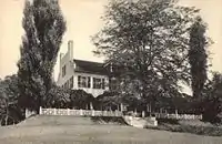 Aspet, home of Augustus Saint-Gaudens
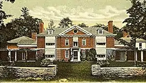 Harlakenden House, built at Cornish, New Hampshire in 1898, summer White House to Woodrow Wilson, burned in 1923
Notable people
- Champion S. Chase, politician
- Jonathan Chase, Revolutionary War officer
- Philander Chase, founder of Kenyon College, sixth Presiding Bishop of the U.S. Episcopal Church
- Salmon P. Chase, justice of the US Supreme Court; born in Cornish
- Winston Churchill, writer
- Thomas Wilmer Dewing, painter
- Michael Dorris, author
- Julie Duncan, actress
- Louise Erdrich, author[9]
- Hamlin Garland, author
- Christian Gerhartsreiter, impostor, convicted murderer
- Learned Hand, judge
- Percy MacKaye, playwright and poet
- Charles A. Platt, architect
- Samuel L. Powers, US congressman
- Augustus Saint-Gaudens, sculptor
- Louis St. Gaudens, sculptor
- J. D. Salinger, writer[10]
- Nathan Smith, physician, founder of Dartmouth and Yale medical schools[11]
- Nathan Ryno Smith, surgeon and professor, son of Nathan Smith
- Woodrow Wilson, US president (summer resident at author Winston Churchill's Harlakenden House)[12]
References
- United States Census Bureau, U.S. Census website, 2010 Census figures. Retrieved March 23, 2011.
- Coolidge, Austin J.; John B. Mansfield (1859). A History and Description of New England. Boston, Massachusetts: A.J. Coolidge. pp. 460–461.
coolidge mansfield history description new england 1859.
- "Cornish Arts Colony in Cornish and Plainfield, NH 1885-1930". www.crjc.org.
- The knob is unnamed on federal topographic maps, but is shown as "Buffalo Mountain" on a hand-drawn map by Ms. Gross, town historian of Croydon.
- Foster, Debra H.; Batorfalvy, Tatianna N.; Medalie, Laura (1995). Water Use in New Hampshire: An Activities Guide for Teachers. U.S. Department of the Interior and U.S. Geological Survey.
- "Annual Estimates of the Resident Population: April 1, 2010 to July 1, 2017 (PEPANNRES): Minor Civil Divisions – New Hampshire". Archived from the original on February 13, 2020. Retrieved November 15, 2018.
- "Census of Population and Housing". Census.gov. Retrieved June 4, 2016.
- "U.S. Census website". United States Census Bureau. Retrieved 2008-01-31.
- Erdrich, Louise; Dorris, Michael (1994). Conversations with Louise Erdrich and Michael Dorris. Univ. Press of Mississippi. ISBN 9780878056521.
- Katie Zezima, "Cornish Journal: J. D. Salinger a Recluse? Well, Not to His Neighbors", The New York Times, January 31, 2010.
- Emily Jones Smith (1914). The Life and letters of Nathan Smith, M.B., M.D. Yale University Press. p. xxvi. Retrieved 6 November 2012.
- Wade, M; Tracy, S. P.; Wood, D. C. (1976). A brief history of Cornish,1763-1974. for the Town of Cornish by University Press of New England. ISBN 978-0-87451-129-1.
External links
| Wikimedia Commons has media related to Cornish, New Hampshire. |
- Town of Cornish official website
- George H. Stowell Free Library
- Local Cornish info
- Yahoo's Cornish neighborhood profile
- Cornish, New Hampshire at City-Data.com
- New Hampshire Economic and Labor Market Information Bureau Profile
- Cornish Fair
- Corbin Park
- Land Use in Cornish, N.H., a 2006 documentary presentation by James M. Patterson of the Valley News
- Cornish (N.H. : Town) Records, 1821-1873 at Dartmouth College Library
Places adjacent to Cornish, New Hampshire | |
|---|---|
Municipalities and communities of Sullivan County, New Hampshire, United States | ||
|---|---|---|
| City | 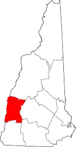 Map of New Hampshire highlighting Sullivan County | |
| Towns | ||
| CDPs | ||
| Other villages | ||
| ||