Dakshin Sunamganj Upazila
Dakshin Sunamganj (Bengali: দক্ষিণ সুনামগঞ্জ) is an upazila of Sunamganj District in the Division of Sylhet, Bangladesh.[1]
South Sunamganj
দক্ষিণ সুনামগঞ্জ | |
|---|---|
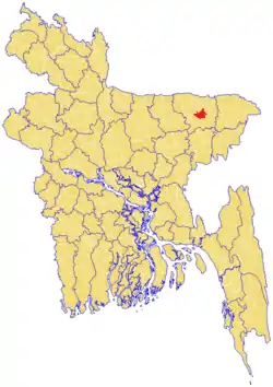 Location of Dakshin Sunamganj in red | |
| Country | |
| Division | Sylhet Division |
| District | Sunamganj District |
| Area | |
| • Total | 303.17 km2 (117.05 sq mi) |
| Population (2011) | |
| • Total | 183,881 |
| • Density | 610/km2 (1,600/sq mi) |
| Demonym(s) | Dakshin Sunamganji, Dokkhin Shunamgoinji/Sunamgonji/Shunamgonji/Sunamgoinji |
| Time zone | UTC+6 (BST) |
| Website | southsunamganj |
Formerly part of Sunamganj Sadar Upazila, it was formed as a separate upazila in 2007.[2]
Geography
Dakshin Sunamganj is located in between 24°49' and 25°10' north latitudes and in between 91°14' and 91°27' east longitudes. It has a total area of 303.17 square kilometres (117.05 sq mi).
Demographics
Dakshin Sunamganj has a total population of 183,881, per the 2011 census. The literacy rate and school attendance is below average of the Sunamganj District, with 32.3% and 43.8% respectively. There are 8 unions within the upazila, with a total of 107 mauzas and 171 villages.[2]
With over 32,000 households, majority (80.6%) of these are kancha or kucha houses which are made from mud or clay, while a few are semi or full pucca houses. A small minority of these houses have access to sanitary latrine (29.2%), majority have non-sanitary latrine (60.4%) and 10.4% do not have toilet facilities available. Electricity within the upazila was available to 38.4% of the population.[2]
Predominantly the population is Muslim (90.3%), a small minority is Hindu (9.7%), and very few following other religions.[2]
Administration
Dakshin Sunamganj Upazila is divided into eight union parishads: Dargapasha, Joykalash, Paschim Birgaon, Paschim Pagla, Patharia, Purba Birgoan, Purba Pagla, and Shimulbak. The union parishads are subdivided into 102 mauzas and 171 villages.[3]
References
- Sirajul Islam and Ahmed A. Jamal, ed. (2012), "Dakshin Sunamganj Upazila", Banglapedia: National Encyclopedia of Bangladesh (Second ed.), Asiatic Society of Bangladesh
- Population & Housing Census 2011 Archived 2015-11-13 at the Wayback Machine Bangladesh Bureau of Statistics.
- "District Statistics 2011: Sunamganj" (PDF). Bangladesh Bureau of Statistics. Archived from the original (PDF) on 13 November 2014. Retrieved 14 July 2014.
Capital: Sunamganj | ||
| Upazilas | ||
| Constituencies | ||
| Attractions and sites | ||
| Rivers | ||
| Inhabited areas | ||
| Educational institutions | ||
| Transport | ||
| History | ||
Capital: Sylhet | ||
| Habiganj District | 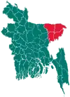 | |
| Moulvibazar District | ||
| Sunamganj District | ||
| Sylhet District | ||