Sullah Upazila
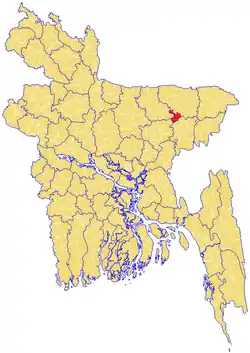
Sullah (Bengali: শাল্লা) or Sulla[1] is an Upazila of Sunamganj District in the Division of Sylhet, Bangladesh.
Sullah শাল্লা | |
|---|---|
| Nickname(s): ঘুঙ্গিয়ারগাও | |
 | |
| Division | Sylhet Division |
| District | Sunamganj District |
| Government | |
| • MP (Sunamganj-2) | Joya Sengupta (Awami League) |
| • Ex-MP (Sunamganj-2) | Suranjit Sengupta |
| Area | |
| • Total | 260.74 km2 (100.67 sq mi) |
| Population | |
| • Total | 89,941 |
| • Density | 340/km2 (890/sq mi) |
| Demonym(s) | Sullawi, Shallawi |
| Time zone | UTC+6 (BST) |
| Postal code | 3000 |
Etymology
Sullah is variant of Shah Ullah, which was named after its founder, Shah Ullah. Locally, it is pronounced and written as Shal'lah.
Geography
Sullah is located at 24.6264°N 91.2500°E. It has 13881 households and total area 260.74 km2.
Demographics
As of the 1991 Bangladesh census, Sullah has a population of 89941. Males constitute 51.08% of the population, and females 48.92%. This Upazila's eighteen up population is 43247. Sullah has an average literacy rate of 21.8% (7+ years), and the national average of 32.4% literate.[2] It has a large Hindu population with over 50% of the upazila.
Administration
Sullah Upazila is divided into four union parishads: Atgaon, Bahara, Habibpur, and Shalla. The union parishads are subdivided into 65 mauzas and 116 villages.[3]
References
- Jiban Kumar Chanda (2012). "Sulla Upazila". In Sirajul Islam and Ahmed A. Jamal (ed.). Banglapedia: National Encyclopedia of Bangladesh (Second ed.). Asiatic Society of Bangladesh.
- "Population Census Wing, BBS". Archived from the original on 2005-03-27. Retrieved November 10, 2006.
- "District Statistics 2011: Sunamganj" (PDF). Bangladesh Bureau of Statistics. Archived from the original (PDF) on 13 November 2014. Retrieved 14 July 2014.
Capital: Sunamganj | ||
| Upazilas | ||
| Constituencies | ||
| Attractions and sites | ||
| Rivers | ||
| Inhabited areas | ||
| Educational institutions | ||
| Transport | ||
| History | ||
Capital: Sylhet | ||
| Habiganj District | 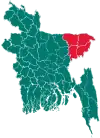 | |
| Moulvibazar District | ||
| Sunamganj District | ||
| Sylhet District | ||