Kanaighat Upazila
Kanaighat (Bengali: কানাইঘাট) is an upazila of Sylhet District in the Division of Sylhet, Bangladesh.[1]
Kanaighat
কানাইঘাট | |
|---|---|
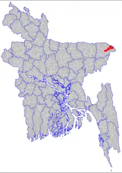 | |
 Kanaighat Location in Bangladesh | |
| Coordinates: 25°1′N 92°14.8′E | |
| Country | |
| Division | Sylhet Division |
| District | Sylhet District |
| Government | |
| • Upazila Chairman | Ashique Uddin Chowdhury |
| Area | |
| • Total | 412.25 km2 (159.17 sq mi) |
| Population (1991) | |
| • Total | 178,654 |
| • Density | 430/km2 (1,100/sq mi) |
| Demonym(s) | Kanaighati, Khanaigati |
| Time zone | UTC+6 (BST) |
| Postal code | 3180 |
| Website | kanaighat |
History
On 23 March 1922, the Kanaighater Larai (Fight of Kanaighat) took place. The Kanaighat madrasa was to hold their annual jalsa on this day but the British Raj imposed on a ban on the jalsa and declared Section 144 throughout Kanaighat. The jalsa organisers were angered by this ban and violated Section 144, and led a mob to attack the British commissioners. The British were able to conduct a swift victory, by using their guns to kill six people and injure 38 people.
During the Bangladesh Liberation War of 1971, the Pakistani Army teamed up with Razakars to do a mass killing in Maligram and Gouripur.[1]
Geography
Kanaighat is located at 25.0166°N 92.2472°E. It has 29568 households and total area 412.25 km2.
Demographics
At the 2001 Bangladesh census, Kanaighat had a population of about 2,50,000. Males constituted 50.49% of the population, and females 49.51%. The population of those aged 18 and older was 85,855. Kanaighat had an average literacy rate of 62% (7+ years). Religions: Muslim 95%, Hindu 4.10%, Christian 0.2%, and tribal 0.3%.
Administration
Kanaighat Upazila is divided into Kanaighat Municipality and nine union parishads: Bara Chatul, Dakshin Banigarm, Jhingrabari, Kanaighat, Paschim Lakshmi Prasad, Satbak (Paschim Dighirpar), Purba Lakshmi Prasad, Purba Dighirpar, and Rajaganj. The union parishads are subdivided into 198 mauzas and 264 villages.[2]
Kanaighat Municipality is subdivided into 9 wards and 26 mahallas.[2]
Notable people
- James Leo Ferguson, tea planter, was born in Kanaighat.[3]
References
- Jayanta Singh Roy (2012). "Kanaighat Upazila". In Islam, Sirajul; Miah, Sajahan; Khanam, Mahfuza; Ahmed, Sabbir (eds.). Banglapedia: the National Encyclopedia of Bangladesh (Online ed.). Dhaka, Bangladesh: Banglapedia Trust, Asiatic Society of Bangladesh. ISBN 984-32-0576-6. OCLC 52727562. Retrieved 31 January 2021.
- "District Statistics 2011: Sylhet" (PDF). Bangladesh Bureau of Statistics. Archived from the original (PDF) on 13 November 2014. Retrieved 14 July 2014.
- Mehdi, Ujjal (11 December 2016). "'I fought for this land'". Prothom Alo.
Capital: Sylhet | ||
| Habiganj District |  | |
| Moulvibazar District | ||
| Sunamganj District | ||
| Sylhet District | ||
