Palamu district
Palamau is one of the twenty-four districts of Jharkhand state, India. It was formed in 1892. The administrative headquarter of the district is Medininagar, situated on the Koel River.
Palamau district | |
|---|---|
District of Jharkhand | |
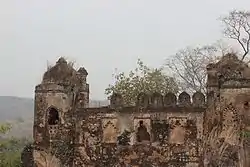 Palamu fort | |
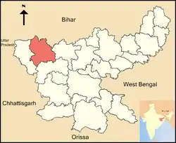 Location of Palamau district in Jharkhand | |
| Country | India |
| State | Jharkhand |
| Division | Palamau |
| Headquarters | Medininagar |
| Government | |
| • Lok Sabha constituencies | 1. Palamau, 2. Chatra (shared with Chatra district) |
| • Vidhan Sabha constituencies | 5 |
| Area | |
| • Total | 5,044 km2 (1,947 sq mi) |
| Population | |
| • Total | 1,939,869 |
| • Density | 380/km2 (1,000/sq mi) |
| Time zone | UTC+05:30 (IST) |
| Major highways | NH 75, NH 98 |
| Website | http://palamu.nic.in/industries_bccl.html |
History
The Palamu district have site of Neolithic and chalcolithic settlement in the confluence of Son and North Koel river in Kabra-Kala mound.[1]
During the medieval period Chero dynasty was ruling in the region which had become tributaries of Mughal empire during rule of Shahjahan and East India Company. In 1812 East India company took direct control of the region.[2]
Geography
The district lies between 23°50′ and 24°8′ north latitude and between 83°55′ and 84°30′ east longitude. It is bordered on the north by Sone River & Bihar and on the east by the Chatra and Hazaribagh districts, on the south by Latehar District and on the west by Garhwa District.
The major rivers flowing through Palamu district are Son, Koel and Auranga. The major crops grown are Rice and Sugarcane. Many minerals are found here like Iron ore, Bauxite, Lithium, Dolomite and Coal.[3]
National protected area
- Betla National Park : Betla National Park is a national park located on the Chota Nagpur Plateau in the Palamu district of Jharkhand, India.
Administration
Blocks/Mandals/Taluka
Palamau district consists of 21 Blocks. The following are the list of the Blocks in Palamau district:
- Bishrampur block
- Chainpur block
- Chatarpur block
- Haidernagar block
- Hariharganj block
- Hussainabad block
- Japla block
- Lesliganj block
- Manatu block
- Medininagar block
- Mohammadganj block
- Naudiha Bazar block
- Nawa Bazar block
- Padwa block
- Pandu block
- Panki block
- Patan block
- Pipra block
- Ramgarh
- Satbarwa block
- Tarhasi block
- Untari Road block
Economy
In 2006 the Ministry of Panchayati Raj named Palamau one of the country's 250 most backward districts (out of a total of 640).[4] It is one of the 24 districts in Jharkhand currently receiving funds from the Backward Regions Grant Fund Programme (BRGF).[4][5]
Demographics
According to the 2011 census Palamau district has a population of 1,939,869,[6] giving it a ranking of 243rd in India (out of a total of 640).[6] The district has a population density of 381 inhabitants per square kilometre (990/sq mi).[6] Its population growth rate over the decade 2001-2011 was 25.94%.[6] Palamu has a sex ratio of 929 females for every 1000 males,[6] and a literacy rate of 65.5%. 27.7% of the population are Scheduled Castes and 9.3% are Scheduled Tribes.[6]
At the time of the 2011 Census of India, 65.49% of the population in the district spoke Hindi, 24.44% Magahi and 6.87% Urdu as their first language.[7]
| Year | Pop. | ±% p.a. |
|---|---|---|
| 1901 | 308,256 | — |
| 1911 | 341,869 | +1.04% |
| 1921 | 364,579 | +0.65% |
| 1931 | 407,004 | +1.11% |
| 1941 | 453,731 | +1.09% |
| 1951 | 490,037 | +0.77% |
| 1961 | 589,337 | +1.86% |
| 1971 | 738,316 | +2.28% |
| 1981 | 950,839 | +2.56% |
| 1991 | 1,192,801 | +2.29% |
| 2001 | 1,537,465 | +2.57% |
| 2011 | 1,939,869 | +2.35% |
| source:[8] | ||
Education
The only university in Medininagar is Nilamber-Pitamber University, created on January 17, 2009.[9][10] The Chief Minister of Jharkhand declared that the Nilamber-Pitamber University would be set up in Medininagar in 2001.[11] There are 66 primary schools, 30 middle schools, 17 Navsirijit schools, 10 high schools and 1 Engineering College in the Medininagar block.[12]
References
- "KABRA – KALA". www.asiranchi.org. Archived from the original on 2013-10-08. Retrieved 2019-08-29.
- "History". latehar.nic.in. Archived from the original on 2019-03-28. Retrieved 2019-08-29.
- "About District | Palamu | India". Retrieved 2020-05-11.
- Ministry of Panchayati Raj (September 8, 2009). "A Note on the Backward Regions Grant Fund Programme" (PDF). National Institute of Rural Development. Archived from the original (PDF) on April 5, 2012. Retrieved September 27, 2011.
- "Puff penalty for Rampal".
- "District Census 2011". Census2011.co.in. 2011. Retrieved 2011-09-30.
- 2011 Census of India, Population By Mother Tongue
- Decadal Variation In Population Since 1901
- http://articles.timesofindia.indiatimes.com/2013-02-03/ranchi/36720999_1_nilamber-pitamber-university-land-acquisition-process-firoz-ahmad
- "Nilamber-Pitamber University". Retrieved December 27, 2012.
- "Chapter IX: Social Services". Jharkhand Draft Annual Plan 2001 - 2002. Archived from the original on March 12, 2005. Retrieved 2007-07-10.
- "Palamu District: Education Profile". Archived from the original on 2007-09-28. Retrieved 2007-07-10.
External links
- Official district government website
- Daltongnaj This website contains much information about Palamu
- Jharkhand Tourism
Places adjacent to Palamu district | ||||||||||
|---|---|---|---|---|---|---|---|---|---|---|
| ||||||||||