Khunti district
Khunti district is one of the twenty-four districts in South Chotanagpur division of the Indian state of Jharkhand. The district of Khunti was carved out of Ranchi district on 12 September 2007. As of 2011, it is the second least populous district of Jharkhand (out of 24), after Lohardaga.[1] Khunti town is the headquarters of the district.
Khunti district | |
|---|---|
District of Jharkhand | |
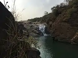 Perua Gagh falls | |
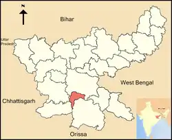 Location of Khunti district in Jharkhand | |
| Country | |
| State | Jharkhand |
| Division | South Chotanagpur division |
| Headquarters | Khunti |
| Government | |
| • Deputy Commissioner | Suraj Kumar, IAS |
| • Lok Sabha constituencies | Khunti (shared with Simdega, Ranchi and Seraikela Kharsawan districts) |
| • Vidhan Sabha constituencies | 3 |
| Area | |
| • Total | 2,611 km2 (1,008 sq mi) |
| Population (2011) | |
| • Total | 531,885 |
| • Density | 200/km2 (530/sq mi) |
| Demographics | |
| • Literacy | 64.51% |
| • Sex ratio | 994 |
| Time zone | UTC+05:30 (IST) |
| Website | khunti |
It is historically known as the birthplace of Birsa Munda, and being the centre of activity of the Birsa movement.[2][3]
The district is currently a part of the Red Corridor.[4]
Local places
Panchghagh waterfall has 5 streams to it. The Banai River branches itself out in five different streams, generating rivulets through the cluster of rocks.
Anganbari –Shiva Temple is a religious center of the district known for its Shiva Temple. Every year during Sawan season local festival is celebrate for one month long. On Maha-shivratri Day, temple is visited by many disciples from different regions of Jharkhand. It is located on Khunti-Torpa road 9 km from the district headquarters.
Dombari Buru rises above Sail Rakab village close to Ulihatu. It is in the hills of Dombari Buru where Birsa Munda led his legendary ulgulan (rebellion) against the British more than a century ago. It is located 50 km from the state capital.
Administration
Blocks/Mandals
Khunti district has one sub-division and 6 blocks. The Deputy Commissioner (DC) of Khunti district is Mr.Suraj Kumar IAS. Khunti sub-division is the only sub-disvision in the district headed by the Sub-Divisional Magistrate(SDM) Mr. Pranav Kumar Pal. Khunti district has six community development blocks. The following are the list of the Blocks in Khunti district:
Demographics
As of 2011 census of India, Khunti district has a population of 531,885,[1] roughly equal to the nation of Cape Verde.[5] This gives it a ranking of 541st in India (out of a total of 640).[1] The district has a population density of 215 inhabitants per square kilometre (560/sq mi) .[1] Its population growth rate over the decade 2001-2011 was 21.96%.[1] Khunti has a sex ratio of 994 females for every 1000 males,[1] and a literacy rate of 64.51%.[1] Schedule Caste (SC) constitutes 4.5% while Schedule Tribe (ST) were 73.3% of total population.
At the time of the 2011 Census of India, 61.72% of the population in the district spoke Mundari, 27.79% Sadri, 5.78% Hindi and 2.9% Panchpargania as their first language.[6]
| Year | Pop. | ±% p.a. |
|---|---|---|
| 1901 | 155,506 | — |
| 1911 | 181,651 | +1.57% |
| 1921 | 174,763 | −0.39% |
| 1931 | 205,234 | +1.62% |
| 1941 | 219,412 | +0.67% |
| 1951 | 243,744 | +1.06% |
| 1961 | 270,551 | +1.05% |
| 1971 | 309,590 | +1.36% |
| 1981 | 334,112 | +0.77% |
| 1991 | 386,330 | +1.46% |
| 2001 | 434,819 | +1.19% |
| 2011 | 531,885 | +2.04% |
| source:[7] | ||
References
- "District Census 2011". Census2011.co.in. 2011. Retrieved 2011-09-30.
- Birsa Mumda commemorative postage stamp and biography India Post, 15 November 1988.
- "Jharkhand Police". Retrieved 2009-03-10.
- "83 districts under the Security Related Expenditure Scheme". IntelliBriefs. 2009-12-11. Retrieved 2011-09-17.
- US Directorate of Intelligence. "Country Comparison:Population". Retrieved 2011-10-01.
Cape Verde 516,100 July 2011 est.
- 2011 Census of India, Population By Mother Tongue
- Decadal Variation In Population Since 1901
