Fairfield, New South Wales
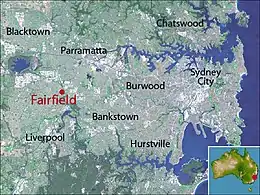
Fairfield is a western suburb of Sydney, in the state of New South Wales, Australia. Being in the centre of the Cumberland Plain, Fairfield is located 23 kilometres (14 mi) west of the Sydney central business district and is the administrative centre for the local government area of the City of Fairfield – Although a very small portion of it is part of the Cumberland Council. Fairfield supports a mixture of commercial and residential developments, mostly characterised by medium-density buildings and some new high-rise apartments.
| Fairfield Sydney, New South Wales | |||||||||||||||
|---|---|---|---|---|---|---|---|---|---|---|---|---|---|---|---|
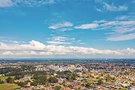 An aerial view of Fairfield | |||||||||||||||
| Population | 18,081 (2016 census)[1] | ||||||||||||||
| • Density | 4,110/km2 (10,640/sq mi) | ||||||||||||||
| Established | 1807 | ||||||||||||||
| Postcode(s) | 2165 | ||||||||||||||
| Area | 4.4 km2 (1.7 sq mi) | ||||||||||||||
| Location | 23 km (14 mi) west of Sydney CBD | ||||||||||||||
| LGA(s) | |||||||||||||||
| State electorate(s) | Fairfield | ||||||||||||||
| Federal Division(s) | |||||||||||||||
| |||||||||||||||
Fairfield is one of the most multicultural and culturally diverse cities in Australia, with more than half of the residents having been born overseas, mostly in non-English speaking countries.[2] The majority of the suburb's dwellers speak a language other than English at home, with the two most common ones being Arabic and Assyrian Neo-Aramaic.[1] Fairfield is an ethnic enclave of Assyrian Christians (mostly from Iraq, and much recently Syria) and other Iraqis of various religious and ethnic origins.[3]
History
For more than 30,000 years, Aboriginal people from the Cabrogal-Gandangara tribe have lived in the Fairfield area.
European settlement, 1780s–1810s
The earliest recorded white settlement in the Fairfield district is described in William Bradley's Journal where he noted an expedition from Rose Hill to Prospect Creek to determine whether Prospect Creek led to Botany Bay. Bradley described a place on the Creek where the water changed from fresh to salt with a drop of 4 feet (1.2 m). The presence of salt water confirmed Prospect Creek's connection to the sea.[4] Breton Gabriel Louis Marie Huon de Kerrileau, a soldier in the NSW Corps arrived in the colony in 1794, having fled France during the French Revolution. In 1807 he received a grant of 100 acres (40 ha) in the centre of Fairfield, which he named Castel Paul.[5] This was an Englished form of the town in which he was born in Brittany, Kastell-Paol, Saint-Pol-de-Léon in French. By 1814 Castel Paul had been combined, by subsequent owners, with several similarly sized grants to form a largely uncleared 700 acres (280 ha) estate.
Early development, 1820s–1920s
The free settler John Horsley purchased the estate in that year and named it Mark Lodge, after family properties in Essex, England.[6] Horsley, a Magistrate and Coroner at Liverpool (1825-1834), and his large family were among the pioneers of white settlement in the Fairfield District. Later, a Colonial Treasurer, Thomas Ware Smart (1810–1881) bought the estate and in the 1860s built the mansion, 'Fairfield House'.[7] Fairfield railway station was opened in 1856 and has the oldest surviving railway building in New South Wales. Development began in the mid 19th century supported by railway construction in 1856. The railway aided with the enlargement of local industries including timber, fruit development and agricultural produce. Around the start of the 20th century the area had a population of 2,500 people and with fertile soils, produced crops for distribution in Sydney. Electricity was connected in 1921.[8]
Post-war period, 1940s–1980s
Rapid population increase after World War II saw the settlement of many ex-service men and European migrants, with Ware Street becoming the new main street, which featured the city's only escalator. The street at that time featured prominent hardware, furniture, menswear and homeware stores, including a Bing Lee. Large scale Housing Commission development in the 1950s swelled the population to 38,000. The Civic Centre was established in the 1960s in Spencer Street and featured many businesses, including the nearby Civic Hotel. Fairfield Hospital was opened in September 1956 on The Horsley Drive, but was relocated to Prairiewood in 1988.[9]
By 1979, the population had reached 120,000 and the City was becoming one of the larger Local Government Areas in New South Wales. In the early 1980s, Fairfield Forum was opened and Ware Street was shut for traffic, with a pedestrian zone established in its stead with a water fountain imported from Italy being the ornament of the civic area. However, the pedestrian plaza was deemed unsuccessful, despite the annual street parades occurring there, and thus Ware Street once again was open to traffic.[10]
Rapid growth, 1980s–2010s
During the mid to late 1980s war between Iraq and Iran, large number of Assyrians fled Iraq and settled in Fairfield, making it the most popular settlement for Assyrians. In 1990, Neeta City was opened due to the rapid growth of Fairfield's commercial centre. An amphitheatre situated in Spencer Street with chess board was closed in the early 2000s with the street reopening to traffic. In the mid 2000s, Fairfield's first high rise apartment building (around 9 to 11 storeys) was constructed, with a number of other high rise buildings which were built consequentially throughout the city centre. In 2005, a small movie theatre in Fairfield Forum was closed in 2005.[11]
In 2015, the Abbott government granted 12,000 extra humanitarian visas to persecuted groups in the war-torn Middle Eastern countries, namely Syria. The Department of Social Services confirmed that 11,400 Iraqi and Syrian refugees (many of whom being Assyrian) were admitted to Australia as part of its one-off humanitarian intake, with half of them primarily settling in Fairfield and also Liverpool. Fairfield City accommodated 3,000 humanitarian arrivals in 2016, taking in 75% of all western Sydney's refugee intake, with Liverpool City Council second at 14%.[12] Fairfield City Centre today features a concoction of retail, commercial and residential developments, including medium density edifices and medium to high-rise shop-top housing developments.
Commercial area
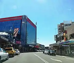
Fairfield consists of a combination of main street retail centred in Smart and Ware Streets, arcade and larger shopping centres, with a variety of activities including retail, café/restaurant/take away foods, supermarkets (with some displayed in a bazaar-style environment), personal services and commercial uses. Although most of these commercial precincts are not a leading part of Fairfield's night time attribute at present, wedding receptions, however, do prevail night activity on the weekends. A couple of shop fronts along The Crescent are in the Federation and Art Deco style, which date from the late 1890s to 1920s, respectively, reflecting its former role as an early main street. The CBD is surrounded by a halo of three storey residential flats, which are beneficial for pedestrian activity to the City Centre. The community holds public gathering and interaction in a high regard, which is manifested by the CBD's active shopping streets and daily social assemblage for playing chess on Kenyon Street.[13]
Fairfield has three shopping malls which were established between the 1980s and early 1990s: Fairfield Forum, Neeta City and Fairfield Chase. The former two are larger and have been refurbished a few times in recent years. The latter has had no refurbishment works undertaken since 1998 and has a vacancy rate of approximately 40%. Forum contains Kmart, Aldi and Coles. Neeta City features a Woolworths supermarket. Fairfield Chase Commercial Tower, Fairfield's first high-rise structure, is an office building atop Chase shopping centre which features government tenants such as NSW Legal Aid, NSW Service for Treatment and Rehabilitation of Torture and Trauma Survivors and employment agencies. Fairfield doesn't feature a formal ‘City Square’, though The Crescent Plaza, opened to the public in December 2016, and Thomas Ware Plaza in Nelson Street, provide a similar sense of fashion to a City Square. The Crescent, Nelson, Ware and Nelson Streets are ornamented by a number of London planetrees.
Culture
Fairfield's large Iraqi and Assyrian community has had the media describe the suburb as 'Little Iraq' or 'Little Baghdad'. More Iraqi businesses have opened in Fairfield, mostly around Ware Street. These businesses include everything from jewellery shops to restaurants, making the area favourite entertainment and shopping hotspot for the Iraqi and Assyrian community. Fairfield's culturally diverse population is reflected in multicultural local businesses such as over twenty different types of cafés and restaurants that include Assyrian, Iraqi, Italian, Chinese, Lebanese, Vietnamese, South American and Thai cuisine.
Sydney's Iraqi community congregated in Fairfield to celebrate Iraq qualifying for the Asian Football Cup finals in 2007. More than 7000 people joined in street celebrations around Fairfield on Sunday 29 July 2007 after Iraq won the Asian Cup finals.
There is also a large library in the heart of the suburb. Fairfield has a few Assyrian churches, sporting clubs, cultural associations and health groups.[14]
Heritage
The School of Arts Building, established in the late 19th century, is a social and historical significance and is an example of Victorian and Federation period styles which are uncommon in the suburb. The Uniting Church is made up of two churches – One of which was built in 1894 and the other in 1927. The first fire brigade built in the city, the Fire Station in William Street, is a free classical style building and is also a historical significance. A federation weatherboard cottage located in Lawson Street was established in around 1910.[15]
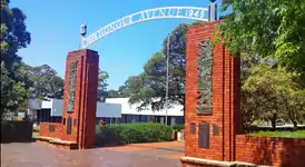
Made up of two red brick entrance pillars, Honour Avenue was built in honor of the Fairfield residents who served in the World Wars and it includes the names of World War II personnel. Its connecting metal arch exhibits the words: '1939 Honour Avenue 1945'. The avenue therein contains large brush boxes on both sides and public seating.
Fairfield has a number of heritage-listed sites, including:
- Great Southern railway: Fairfield railway station, Sydney, the oldest Railway Station in New South Wales and one of the oldest groups of buildings in Fairfield City, which are Mid-Victorian, Georgian Style public buildings dating back to 1856.[16]
Media
Fairfield has two local newspapers, The Fairfield Advance and the Fairfield Champion, which are issued every Wednesday.
Transport
Fairfield railway station is on the Inner West & Leppington and Cumberland lines of the Sydney Trains network. Trains run frequently from Fairfield to Leppington, Parramatta and the City Circle. Fairfield also has a major bus interchange adjacent to the railway station. For details of bus services from the interchange see Fairfield railway station. The Horsley Drive is a prominent road in Fairfield, with a high amount of traffic, and acts as a pivotal entrance to the city from the north and southeast. Hamilton Road to the southwest is another.[17]
Schools
Public Schools in Fairfield include: Fairfield High School, Fairvale High School, Fairvale Public School and Fairfield Public School. Private Schools are: Patrician Brothers' College and Our Lady of the Rosary Primary School, which are catholic schools, and Pal Buddhist School, which is a selective private Buddhist school for Primary and Secondary students. Patrician Brothers' Primary School was also previously located in Fairfield but closed in 2006.
Geography
Much of the original bushland cover within the City has been cleared through past land management practices. A few small areas of this original bushland remain, including examples of Cumberland Plain vegetation, which is listed under the Threatened Species Conservation Act. The Australian white ibis are specifically present in The Crescent, opposite of the train station.
Eight creeks, 80 kilometres in length, have their headwaters in Fairfield City and flow into the Georges River and Hawkesbury Nepean catchments. The impact of development over the past 50 years has resulted in severe degradation of the natural habitat in the creek banks and water quality has been assessed as very poor in recent years. Strategies are being implemented so that this trend is being reversed. Air quality in the City is heavily impacted upon by an insufficiently integrated public transport system, creating an over reliance upon private vehicles for moving people and freight.
Climate
Fairfield has a humid subtropical climate (Köppen climate classification: Cfa). Summer weather may come from north-east (humid) or the north west (dry). Fairfield is usually a few degrees warmer than Sydney on summer days and a few degrees cooler on winter nights. There could be a temperature differential of 5 degrees Celsius in summer due to sea breezes in the City that don't generally penetrate inland, and in extreme cases there could be a 10 degrees differential. It receives less annual rain than Sydney CBD by about 400mm. Even though fair amount of rain is spread throughout the year, late winter and early spring get the least rain, whilst late summer and autumn receive more rain.[18]
| Climate data for Prospect Reservoir[note a] | |||||||||||||
|---|---|---|---|---|---|---|---|---|---|---|---|---|---|
| Month | Jan | Feb | Mar | Apr | May | Jun | Jul | Aug | Sep | Oct | Nov | Dec | Year |
| Record high °C (°F) | 44.7 (112.5) |
42.5 (108.5) |
39.5 (103.1) |
37.1 (98.8) |
29.4 (84.9) |
25.6 (78.1) |
26.5 (79.7) |
29.4 (84.9) |
35.0 (95.0) |
39.0 (102.2) |
42.0 (107.6) |
42.7 (108.9) |
44.7 (112.5) |
| Average high °C (°F) | 28.4 (83.1) |
27.9 (82.2) |
26.3 (79.3) |
23.6 (74.5) |
20.3 (68.5) |
17.3 (63.1) |
16.8 (62.2) |
18.7 (65.7) |
21.3 (70.3) |
23.7 (74.7) |
25.3 (77.5) |
27.5 (81.5) |
23.1 (73.6) |
| Average low °C (°F) | 17.6 (63.7) |
17.7 (63.9) |
16.1 (61.0) |
13.0 (55.4) |
10.0 (50.0) |
7.4 (45.3) |
6.1 (43.0) |
6.8 (44.2) |
9.4 (48.9) |
12.1 (53.8) |
14.2 (57.6) |
16.4 (61.5) |
12.2 (54.0) |
| Record low °C (°F) | 10.0 (50.0) |
10.8 (51.4) |
7.9 (46.2) |
3.6 (38.5) |
1.2 (34.2) |
−0.8 (30.6) |
−0.6 (30.9) |
−0.5 (31.1) |
2.6 (36.7) |
4.5 (40.1) |
6.8 (44.2) |
7.8 (46.0) |
−0.8 (30.6) |
| Average precipitation mm (inches) | 93.7 (3.69) |
96.0 (3.78) |
95.6 (3.76) |
74.1 (2.92) |
72.0 (2.83) |
74.9 (2.95) |
57.0 (2.24) |
50.3 (1.98) |
47.1 (1.85) |
59.4 (2.34) |
72.4 (2.85) |
75.2 (2.96) |
868.1 (34.18) |
| Average precipitation days | 10.7 | 10.6 | 10.9 | 9.3 | 9.0 | 9.4 | 7.8 | 8.0 | 8.5 | 9.4 | 9.5 | 9.9 | 113.0 |
| Source: [19] | |||||||||||||
| Climate data for Bankstown Airport | |||||||||||||
|---|---|---|---|---|---|---|---|---|---|---|---|---|---|
| Month | Jan | Feb | Mar | Apr | May | Jun | Jul | Aug | Sep | Oct | Nov | Dec | Year |
| Record high °C (°F) | 44.8 (112.6) |
43.3 (109.9) |
41.6 (106.9) |
36.9 (98.4) |
28.5 (83.3) |
25.4 (77.7) |
26.7 (80.1) |
30.2 (86.4) |
35.6 (96.1) |
39.7 (103.5) |
43.1 (109.6) |
43.6 (110.5) |
44.8 (112.6) |
| Average high °C (°F) | 28.2 (82.8) |
27.8 (82.0) |
26.2 (79.2) |
23.7 (74.7) |
20.4 (68.7) |
17.7 (63.9) |
17.2 (63.0) |
18.9 (66.0) |
21.5 (70.7) |
23.7 (74.7) |
25.1 (77.2) |
27.3 (81.1) |
23.1 (73.6) |
| Average low °C (°F) | 18.1 (64.6) |
18.1 (64.6) |
16.2 (61.2) |
12.7 (54.9) |
9.6 (49.3) |
6.6 (43.9) |
5.1 (41.2) |
6.0 (42.8) |
8.7 (47.7) |
11.8 (53.2) |
14.3 (57.7) |
16.6 (61.9) |
12.0 (53.6) |
| Record low °C (°F) | 10.4 (50.7) |
10.0 (50.0) |
7.8 (46.0) |
2.4 (36.3) |
1.3 (34.3) |
−1.9 (28.6) |
−4.0 (24.8) |
−0.7 (30.7) |
0.0 (32.0) |
4.4 (39.9) |
6.8 (44.2) |
6.3 (43.3) |
−4.0 (24.8) |
| Average precipitation mm (inches) | 90.3 (3.56) |
106.4 (4.19) |
97.7 (3.85) |
83.2 (3.28) |
71.1 (2.80) |
73.1 (2.88) |
44.6 (1.76) |
49.1 (1.93) |
44.7 (1.76) |
62.1 (2.44) |
77.2 (3.04) |
67.2 (2.65) |
867.0 (34.13) |
| Average precipitation days | 11.1 | 10.9 | 11.3 | 8.8 | 9.8 | 9.3 | 8.0 | 7.3 | 7.7 | 9.5 | 11.0 | 9.8 | 114.5 |
| Source: [20] | |||||||||||||
^[note a] : Fairfield is a large suburb, therefore some areas in it may be proximate to the climate of the top or bottom table
Demographics
According to the 2016 census, the suburb of Fairfield had a population of 18,081 people, the majority of whom (67.3%) were born outside of Australia.
- Country of birth
The largest groups were born in Iraq (22.3%), Vietnam (9.0%), Syria (3.7%), China (2.9%) and Cambodia (2.2%).
- Languages
Only 17.4% of people spoke English as their only home language. The most common language spoken other than English is Neo-Aramaic at 35.6% Assyrian Neo-Aramaic at 6.8%, Arabic at 14.3% (mostly Iraqi Arabic, then Syrian Arabic and other varieties of Arabic), Vietnamese at 11.0%, and Spanish at 4.5%.
- Ethnicity
The most common ethnic groups were Assyrian (11.9%), Vietnamese (9.4%), Chinese (8.8%), Iraqi (7.9%) and Australian (3.4%).
- Religion
The top responses for religious affiliation were Catholic (31.7%), Buddhism (11.6%), No Religion (10.6%) and Islam (9.7%). Christianity was the largest religious group reported overall (61.5%).
- Families
49.4%% were couple families with children, 22.4% were couple families without children and 24.7% were one parent families. Children aged 0–14 years made up 20.9% of the population. Of people over 15 years, 48.2% were married and 12.7% were either divorced or separated. 12.9% of single parents were male and 87.1% were female. Of all households, 76.5% were family households, 21.1% were single person households and 2.4% were group households.
- Dwellings and occupation
Of occupied private dwellings in Fairfield, 39.6%% were separate houses, 13.4%% were semi-detached or townhouses and 46.0% were apartments. 21.3%% of the dwellings were owned and 55.0% were rented. The median family income of people living in Fairfield ($650 per week) was much lower than the national median ($1481).[1]
Politics
Fairfield's mayor is Frank Carbone, Guy Zangari as State MP, Chris Bowen and Chris Hayes as Federal MPs for the seats of McMahon and Fowler respectively.
| 2019 State Elections Electoral district of Fairfield: First preference votes[21] | ||
|---|---|---|
| Labor | 57.2% | |
| Liberal | 25.4% | |
| Christian Democrats | 9.6% | |
| Greens | 7.6% | |
Sports and recreation
Fairfield Adventure Park, a large playground for older children and teens, was opened in April 2015.[22] Nearby is the Fairfield Youth and Community Centre and the Fairfield Leisure Centre, an aquatic centre. These facilities are all situated in Fairfield Park Precinct, a large urban park and sports ground. Prospect Creek winds through it.[23]
Fairfield is also the home suburb of the Fairfield Bulls and Fenix FCS football clubs.
The Crescent Park is adjacent to the station, which features public seating surrounded by native and exotic plants. Another green space in the city is the David Carty Reserve, which is a small, round islet, surrounded by Fairfield Street and The Horsley Drive, that features a number of prominent Hill's weeping figs, and camphor trees – which are introduced evergreens native to East Asia.
Gallery
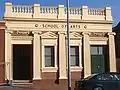 School of Arts
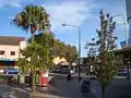 Thomas Ware Plaza
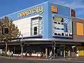 Neeta City shopping centre
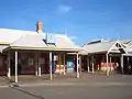 Fairfield Railway Station
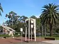 Clock Tower, The Crescent Park
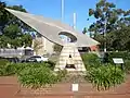 International Monument
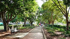 Avenue of remembrance in Fairfield Park
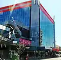 Fairfield Chase Commercial Tower
Notable people
- Mark Bosnich, Australian Socceroos player
- Mitchell Claydon, Australian-English cricketer
- Jelena Dokić, Australian tennis player
- Jon English, singer, songwriter, musician and actor
- Glenn Grief, Australian rugby league player
- Les Hill, Australian actor
- Justice Crew, winners of Australia's Got Talent in 2010
- Harry Kewell, Australian Socceroos player
- David Klemmer, Australian rugby league player
- Bing Lee, Founder of the Bing Lee enterprise
- Bill Summerell, Australian rugby league player
- Maria Tran, filmmaker, Artist-in-residence Powerhouse Youth Theatre 2018
- Gough Whitlam, 21st Prime Minister of Australia (1972 to 1975)
- Ruben Zadkovich, Newcastle Jets and Australian Socceroos player
See also
References
- Australian Bureau of Statistics (27 June 2017). "Fairfield (State Suburb)". 2016 Census QuickStats. Retrieved 27 June 2017.

- "Archived copy". Archived from the original on 6 October 2014. Retrieved 1 June 2011.CS1 maint: archived copy as title (link)
- B. Furze, P. Savy, R. Brym, J. Lie, Sociology in Today's World, 2008, p. 349
- A Voyage to New South Wales - William Bradley NLA No.Aus 68-1986 p168
- Walsh, G. P. (1966). "Huon de Kerilleau, Gabriel Louis Marie (1769 - 1828)". Australian Dictionary of Biography. Melbourne University Press. ISSN 1833-7538. Retrieved 2 June 2011 – via National Centre of Biography, Australian National University.
- NSWBMD V18341819, 18/1834; Horsley, John
- The Book of Sydney Suburbs, Compiled by Frances Pollon, Angus & Robertson Publishers, 1990, Published in Australia ISBN 0-207-14495-8, page 103
- Sydney's Forgotten Quarry Railways Oakes, John ISBN 0-9757870-3-9 pp28-37
- The Heritage of Australia, Macmillan Company, 1981, p.2/24
- Fairfield City Council (1999) Management Plan for Fairfield City 1999-2003 Fairfield City Council
- Gorgees, P. 2003, ‘The Assyrian Community’s Continued Needs in the Fairfield LGA’, in Checking the Pulse of Fairfield―Conference Report, Fairfield Migrant Resource Centre, Cabramatta.
- Dabbagh, Omar (15 May 2017). "Assyrian Australians plead for second special refugee settlement deal". Retrieved 22 June 2017.
- 2012-2013 annual report
- "World on a plate". The Sydney Morning Herald. 13 November 2007.
- Fairfield City Centre Development Control Plan
- "Fairfield Railway Station group". New South Wales State Heritage Register. Office of Environment and Heritage. H01143. Retrieved 18 May 2018.
- Clouston (1999) Fairfield Open Space Strategy prepared for Fairfield City Council
- http://www.bom.gov.au/climate/current/month/nsw/archive/200611.sydney.shtml
- "Climate statistics for Prospect Reservoir". Bureau of Meteorology. July 2011. Retrieved 21 July 2011.
- "Monthly climate statistics". Bureau of Meteorology. 20 July 2011. Retrieved 22 July 2011.
- https://vtr.elections.nsw.gov.au/la/fairfield/cc/fp_summary NSW STATE ELECTION RESULTS 2019 Saturday 23 March 2019, State Electoral District of Fairfield
- http://www.fairfieldcity.nsw.gov.au/info/20002/planning_and_building/319/major_projects Fairfield Adventure Park
- http://www.fairfieldcityleisurecentres.com.au/fairfield-leisure-centre/ Fairfield Leisure Center
External links
| Wikimedia Commons has media related to Fairfield, New South Wales. |