Wood Buffalo National Park
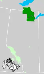
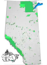
Wood Buffalo National Park is the largest national park of Canada at 44,807 km2 (17,300 sq mi). It is located in northeastern Alberta and the southern Northwest Territories. Larger in area than Switzerland,[2] it is the second-largest national park in the world.[3] The park was established in 1922 to protect the world's largest herd of free roaming hybridized[4] wood bison, currently estimated at more than 5,000.[5][6][7] It is one of two known nesting sites of whooping cranes.
| Wood Buffalo National Park | |
|---|---|
IUCN category II (national park)[1] | |
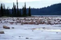 Grosbeak Lake | |
 Location of Wood Buffalo National Park  Wood Buffalo National Park (Alberta) | |
| Location | Alberta and Northwest Territories, Canada |
| Nearest city | Fort Chipewyan Fort Smith |
| Coordinates | 59°23′N 112°59′W |
| Area | 44,807 km2 (17,300 sq mi) |
| Established | 1922 |
| Governing body | Parks Canada |
| Website | pc |
| Criteria | Natural: vii, ix, x |
| Reference | 256 |
| Inscription | 1983 (7th session) |
The park ranges in elevation from 183 m (600 ft) at the Little Buffalo River to 945 m (3,100 ft) in the Caribou Mountains. The park headquarters is located in Fort Smith, with a smaller satellite office in Fort Chipewyan, Alberta. The park contains one of the world's largest fresh water deltas, the Peace-Athabasca Delta, formed by the Peace, Athabasca and Birch Rivers. It is also known for its karst sinkholes in the north-eastern section of the park. Alberta's largest springs (by volume, with an estimated discharge rate of eight cubic meters per second), Neon Lake Springs, are located in the Jackfish River drainage.[8] Wood Buffalo is located directly north of the Athabasca Oil Sands.
This area was designated a UNESCO World Heritage Site in 1983 for the biological diversity of the Peace-Athabasca Delta, one of the world's largest freshwater deltas, as well as the population of wild bison. It is also the most ecologically complete and largest example of the Great Plains-Boreal grassland ecosystem of North America.[9]
On June 28, 2013, the Royal Astronomical Society of Canada designated Wood Buffalo National Park as Canada's newest and the world's largest dark-sky preserve. The designation helps preserve nighttime ecology for the park's large populations of bats, night hawks and owls, as well as providing opportunities for visitors to experience the northern lights.[10]
History
Before the park
This region has been inhabited by human cultures since the end of the last ice age. Aboriginal peoples in this region have followed variations on the subarctic lifeway, based around hunting, fishing, and gathering. Situated at the junction of three major rivers used as canoe routes for trade — the Athabasca, Peace and the Slave Rivers — the region that later became the national park was well travelled for millennia.
In recorded times, the Dane-zaa (historically called the "Beaver tribe"), the Chipewyan people, the South Slavey (Dene Thaʼ), and Woods Cree people are known to have inhabited, and sometimes quarrelled over, the region. The Dane-zaa, Chipewyan, and South Slavey speak (or spoke) languages from the Northern Athabaskan family, which is also common in the regions to the north and west of the park, and call themselves the "Dene" collectively. The Cree, by contrast, are an Algonquian people and are thought to have migrated here from the east within the timeframe of recorded history.
Sometime after 1781 when a smallpox epidemic decimated the region, the two groups made a peace treaty at Peace Point through a ceremonial pipe ceremony. This is the origin of the name of the Peace River which flows through the region: the river became the boundary with the Dane-zaa to the North and the Cree to the South.
Explorer Peter Pond is believed to have passed through the region in 1785, likely the first European to do so, followed by Alexander Mackenzie three years later. In 1788 fur trading posts were established at Fort Chipewyan just east of the current boundaries of the park and Fort Vermilion just to the west. And the Peace River, which had long been used by the First Nations as a trade route, also now also added to the growing network of canoe routes used in the North American fur trade. From the fur trade, the Métis people emerged as another major group in the region.
Canada purchased the Hudson's Bay Company's claim to the region in 1870. Agriculture was never developed in this part of Western Canada, unlike to the south; thus hunting and trapping remained the dominant industry in this region well into the twentieth century, and are still vital to many of its inhabitants. Following the Klondike Gold Rush of 1897, however, the Canadian government was keen to extinguish Aboriginal title to the land, so that any mineral wealth found in the future could be exploited despite any objections from First Nations. This led to the signing of Treaty 8 on 21 June 1899. The land then passed into the hand of the federal government as Crown land.
As a national park
.jpg.webp)
Established in 1922, the park was created on Crown land acquired the territory of Treaty 8 between Canada and the local First Nations. The park itself completely surrounds several Indian reserves such as Peace Point and ʔejëre K’elnı Kuę́ (also called Hay Camp).
Despite protests from biologists, nearly 6,700 plains bison were introduced from Buffalo National Park, to avoid unwanted mass culling due to over-population, by the Government of Canada between 1925 and 1928,[11] where they hybridized with the local 1,500-2,000 wood bison, as well as introducing bovine tuberculosis and brucellosis diseases into the herd.[12] Parks officials have since that time attempted to undo this damage with successive culls of diseased animals. In 1957, however, a disease-free, relatively pure wood bison herd of 200 was discovered near Nyarling river. In 1965, 23 of these bison were relocated to the south side of Elk Island National Park and 300 remain there today as the most genetically pure wood bison remaining. Between 1951 and 1967, 4000 bison were killed and 2,000,000 pounds (910 t) of meat were sold from a special abattoir built at Hay Camp. These smaller culls did not eradicate the diseases, however, and in 1990 a plan was announced to cull the entire herd and restock it with undiseased animals from Elk Island National Park.[13] This plan was abandoned due to a negative public reaction to the announcement.[12] Since that time, wolves, the bison's main predator, have recovered in numbers due to a reduction in control efforts (mostly poisoning), reducing the size of the herd.
In 1983, a 21-year lease was granted to Canadian Forest Products Ltd. to log a 50,000-hectare area of Wood Buffalo National Park. The Canadian Parks and Wilderness Society filed a lawsuit against Parks Canada for violating the National Parks Act. Before the trial commenced in 1992, Parks Canada acquiesced and recognized that the lease was invalid and unauthorized by the provisions of the act.[14]
In March 2019, Kitaskino Nuwenëné Wildland Provincial Park was established on the borders of the Wood Buffalo National Park. The protection of this park was first proposed by the Mikisew Cree First Nation, and it will protect the natural ecosystems from the expanding industrial areas north of Fort McMurray. The park was created after three oil companies – Teck Resources, Cenovus Energy, and Imperial Oil – voluntarily gave up certain oilsands and mining leases in the area, following negotiations with the Alberta government and indigenous groups. This provincial park will be closed to forestry and new energy projects, but existing wells in the area can keep producing and traditional indigenous land uses are allowed.[15]
In June 2019, UNESCO expressed concerns about managements of ecological health and indigenous usage especially water decline, and "warned" the park about potential delisting it from the World Heritage List.[16] Canada in response announced to fund $27.5 million to solve the problems, but UNESCO questioned and did not lift the potential delisting of the park, and the report by Canada will be reviewed by the World Heritage Committee in 2021.[17]
Climate
In the park, summers are very short, but days are long.[18] Temperatures range between 10 to 30 °C (50.0 to 86.0 °F) during this season.[18] On average, summers are characterized by warm and dry days although in some years, it can have cool and wet days.[18] The mean high in July is 22.5 °C (72.5 °F) while the mean low is 9.5 °C (49.1 °F).[18] Fall tends to have cool, windy and dry days in which the first snowfall usually occurs in October.[18] Winters are cold with temperatures that can drop below −40 °C (−40.0 °F) in January and February, the coldest months.[18] The mean high in January is −21.7 °C (−7.1 °F) while the mean low is −31.8 °C (−25.2 °F).[18] In spring, temperatures gradually warm up as the days become longer.[18]
Wildlife
Wood Buffalo National Park contains a large variety of wildlife species, such as red fox, bison, moose, great grey owls, black bears, hawks, timber wolves, lynxes, beavers, snowy owls, marmots, bald eagles, martens, wolverines, peregrine falcons, whooping cranes, snowshoe hares, sandhill cranes, ruffed grouses, and the world's northernmost population of red-sided garter snakes, which form communal dens within the park. Cougars, feral horses, and muskoxes have been recorded within and vicinity of the park.[19][20][21][22][23]
Wood Buffalo Park contains the only natural nesting habitat for the endangered whooping crane. Known as Whooping Crane Summer Range, it is classified as a Ramsar site. It was identified through the International Biological Program. The range is a complex of contiguous water bodies, primarily lakes and various wetlands, such as marshes and bogs, but also includes streams and ponds.
In 2007, the world's largest beaver dam – about 850-metre (2,790 ft) in length – was discovered in the park using satellite imagery;[24][25][26] The dam, located at 58°16.3′N 112°15.1′W,[27] about 200 kilometres (120 mi) from Fort Chipewyan, had only been sighted by satellite and fixed-wing aircraft until July 2014.[28][29]
Hybrid bison
As above-mentioned, "wood bison" in the park are hybrid descendants between outnumbering, disease-infected plains bison translocated from Buffalo National Park into Wood Buffalo National Park in 1920s.[30] However, a study in 1995 detected that there have been notable differences in morphology among each herds within the park, showing different degrees of hybridization. The herd at the Sweetgrass Station nearby Peace–Athabasca Delta, followed by Slave River Lowlands herd, preserves relatively loyal phenotype to the original wood bison before 1920s, even surpassing the preserved herds at Elk Island National Park and Mackenzie Bison Sanctuary.[31]
Transportation
Year-round access is available to Fort Smith by road on the Mackenzie Highway, which connects to Highway 5 near Hay River, Northwest Territories. Commercial flights are available to Fort Smith and Fort Chipewyan from Edmonton.[32] Winter access is also available using winter and ice roads from Fort McMurray through Fort Chipewyan.
Gallery
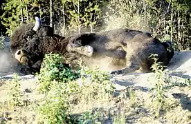 Wood bison (not pure)
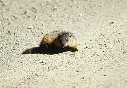
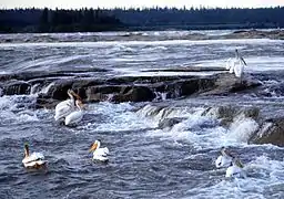 American white pelicans at Rapids of the Drowned (Slave River)
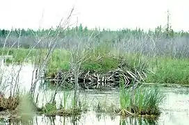 Beaver lodge
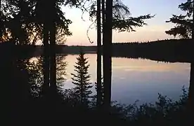 Pine Lake
See also
- Buffalo National Park
- List of mountains in Alberta
- List of National Parks of Canada
- List of Northwest Territories parks
- List of parks in Alberta
- List of trails in Alberta
- List of waterfalls of Alberta
- National Parks of Canada
![]() Canada portal
Canada portal
References
- "Protected Planet | Wood Buffalo National Park Of Canada". Protected Planet. Retrieved 2020-10-13.
- "World's largest beaver dam". Parks Canada–Wood Buffalo National Park. Archived from the original on 9 February 2016. Retrieved 12 January 2016.
- Johnston, Karl. "Heaven Below Me – Exploring Wood Buffalo National Park from the Air". Let's Be Wild. Retrieved 16 November 2012.
- Natural World Heritage Site
- https://www.thechronicleherald.ca/news/canada/more-staff-artificial-flooding-among-plans-to-save-wood-buffalo-national-park-280877/. Missing or empty
|title=(help)(dead link) - "Ottawa produces action plan for Wood Buffalo National Park" – via The Globe and Mail.
- https://cklbradio.com/feds-have-new-plan-to-preserve-wood-buffalo-national-park/. Missing or empty
|title=(help)(dead link) - Rollins, John (2004). Caves Of The Canadian Rockies And Columbia Mountains. Surrey, Canada: Rocky Mountain Books. ISBN 978-0-92110-294-6. Retrieved 25 May 2015.
- "Wood Buffalo National Park: Statement of Significance". UNESCO World Heritage Centre. Retrieved 18 December 2014.
- Thompson, Deborah (2 August 2013). "RASC Designates Wood Buffalo National Park as a New Dark Sky Preserve" (Press release). Toronto, Canada. Retrieved 3 August 2013.
- Jack Van Camp, 1989, A Surviving Herd of Endangered Wood Bison at Hook Lake, N.W.T.?, Arctic, Vol. 42, No. 4 (Dec., 1989), pp. 314-322
- Sandlos, John (2013). "Northern bison sanctuary or big ranch? Wood Buffalo National Park". Arcadia Project. Environment & Society Portal. ISSN 2199-3408. Retrieved 25 May 2015.
- Brooymans, Hanneke (2008-05-14). "Alberta to allow hunters to kill Hay-Zama bison". Canwest Digital Media/The Vancouver Sun. Archived from the original on 2012-11-04. Retrieved 2008-06-02.
- Boyd, David R. (2004). Unnatural Law: Rethinking Canadian Environmental Law and Policy. Vancouver: UBC Press, University of British Columbia. ISBN 0-7748-1048-3.
- Narwhal, The. "Three oilsands companies surrender land for new Alberta park to be co-managed with First Nations". The Narwhal. Retrieved 2019-04-08.
- UN says Canada’s plan to rescue Wood Buffalo National Park needs ‘considerably more effort’, Bob Weber, The Canadian Press, June 13, 2019
- Wood Buffalo ‘doomed without quick action’ as UN extends deadline, Cabin Radio, Published: July 3, 2019 Sarah Pruys
- "Wood Buffalo National Park Weather". Parks Canada. Retrieved August 22, 2015.
- Gau, Robert J.; Mulders, Robert; Lamb, Tamara; Gunn, Libby (2001). "Cougars (Puma concolor) in the Northwest Territories and Wood Buffalo National Park" (PDF). Arctic. 54 (2). doi:10.14430/ARCTIC778. S2CID 131593564.
- Cohen, Sidney (July 26, 2019). "Gotta see it to believe it: Man hunts muskox in northern Alberta". CBC News. Retrieved 2020-11-22.
- "Musk ox sighted in northern Alberta". CBC News. June 20, 2012. Retrieved 2020-11-22.
- "Wild horses spotted near Wood Buffalo National Park". CBC News. March 22, 2016. Retrieved 2020-11-22.
- "Wild Horses Roam Wood Buffalo". _EDGE. 2016-03-16. Retrieved 2020-09-08.
- Kleiss, Karen (6 May 2010). "Giant beaver pond visible from space". The Vancouver Sun. Canwest News Service. Archived from the original on 8 May 2010. Retrieved 18 September 2014.
- Comte, Michel; Lemieux, Jacques (5 May 2010). "World's biggest beaver dam discovered in northern Canada". Yahoo!. L'Agence France-Presse. Archived from the original on 9 May 2010. Retrieved 18 September 2014.
- "Largest Beaver Dam Seen From Space". Discovery News. L'Agence France-Presse. 6 May 2010. Retrieved 25 May 2015.
- Thie, Jean. "Exploring Beaver Habitat and Distribution with Google Earth: The Longest Beaver Dam in the World". EcoInformatics International. Retrieved 18 September 2014.
- Lilwall, Scott (19 September 2014). "U.S. Explorer Reaches World's Largest Beaver Dam: Adventurer Bushwacks Through Dense Northeast Alberta Boreal Forest". CBC New Canada. CBC/Radio-Canada. Retrieved 14 May 2016.
- Klinkenberg, Marty (18 September 2014). "U.S. Explorer Reaches World's Largest Beaver Dam: Adventurer Bushwacks Through Dense Northeast Alberta Boreal Forest". Water Supply Association of B.C. Edmonton Journal. Retrieved 25 May 2015.
- C. G Van Zyll de Jong , 1986, A systematic study of recent bison, with particular consideration of the wood bison (Bison bison athabascae Rhoads 1898), National Museum of Natural Sciences
- Phenotypic Variation in Remnant Populations of North American Bison, C. G. van Zyll de Jong, C. Gates, H. Reynolds and W. Olson; Journal of Mammalogy, Vol. 76, No. 2 (May, 1995), pp. 391-405
- "Wood Buffalo National Park of Canada - How to Get There". Parks Canada. Archived from the original on 15 June 2006. Retrieved 25 May 2015.
External links
| Wikimedia Commons has media related to Wood Buffalo National Park. |
| Wikivoyage has a travel guide for Wood Buffalo National Park. |
| 🌍 |
- Official website

- "Aerial photos of Wood Buffalo National Park", Canadian Geographic
- Park at UNESCO World Heritage Site
- Great Canadian Parks
- Wood Buffalo National Park, Canada (IUCN)
| National parks | |
|---|---|
| National historic sites |
|
| Territorial parks |
|
| Other | |
| |
| Western | |
|---|---|
| Eastern | |
| Northern | |
| Tentative List | |
| Former |
|
| |
| Authority control |
|---|