Geography of South Korea
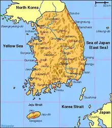
South Korea is located in East Asia, on the southern half of the Korean Peninsula located out from the far east of the Asian landmass. The only country with a land border to South Korea is North Korea, lying to the north with 238 kilometres (148 mi) of the border running along the Korean Demilitarized Zone. South Korea is mostly surrounded by water and has 2,413 kilometres (1,499 mi) of coast line along three seas; to the west is the Yellow Sea (called Sohae Korean: 서해; Hanja: 西海; in South Korea, literally means west sea), to the south is the East China Sea, and to the east is the Sea of Japan (called Donghae Korean: 동해; Hanja: 東海; in South Korea, literally means east sea). Geographically, South Korea's landmass is approximately 100,032 square kilometres (38,623 sq mi).[1] 290 square kilometres (110 sq mi) of South Korea are occupied by water. The approximate coordinates are 37° North, 128° East.
Land area and borders
The Korean Peninsula extends southward from the northeast part of the Asian continental landmass. The Japanese islands of Honshū and Kyūshū are located some 200 km (124 mi) to the southeast across the Korea Strait; the Shandong Peninsula of China lies 190 kilometers to the west. The west coast of the peninsula is bordered by the Korea Bay to the north and the Yellow Sea and Korea Strait to the south; the east coast is bordered by the Sea of Japan. The 8,640-kilometer coastline is highly indented. Some 3,579 islands lie adjacent to the peninsula. Most of them are found along the south and west coasts.
The line between the two Korean states was the thirty-eighth parallel of latitude. After the Korean War, the Korean Demilitarized Zone (DMZ) formed the boundary between the two. The DMZ is a heavily guarded, 4,000-meter-wide strip of land that runs along the demarcation line established by the Korean Armistice Agreement from the east to the west coasts for a distance of 241 kilometers (238 kilometers of that line from the land boundary with North Korea).
The total land area of the peninsula, including the islands, is 223,170 square kilometers. Some 44.8 percent (100 210 square kilometers) of this total, excluding the area within the DMZ, constitutes the territory of the Republic of Korea. The combined territories of North Korea and South Korea are about the same size as the U.S. state of Minnesota. South Korea alone is about the size of Portugal or Hungary, or the U.S. state of Indiana.[2]
The largest island, Jeju-do, lies off the southwest corner of the peninsula and has a land area of 1,825 square kilometers. Other important islands include Ulleung and Liancourt Rocks in the Sea of Japan and Ganghwa Island at the mouth of the Han River. Although the eastern coastline of South Korea is generally unindented, the southern and western coasts are jagged and irregular. The difference is caused by the fact that the eastern coast is gradually rising, while the southern and western coasts are subsiding.
Topography and drainage
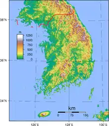
Early European visitors to Korea remarked that the land resembled "a sea in a heavy gale" because of the large number of successive mountain ranges that crisscross the peninsula. The highest mountains are in North Korea. The highest mountain peak in South Korea is Hallasan (1,950 m (6,398 ft)), which is the cone of a volcanic formation constituting Jeju Island. There are two major mountain ranges within South Korea: the Taebaek Mountains, and the Sobaek Mountains.
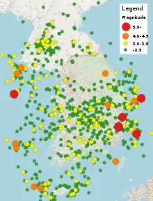
Unlike Japan or the northern provinces of China, the Korean Peninsula is geologically stable. There are no active volcanoes (aside from Baekdu Mountain on the border between North Korea and China, most recently active in 1903), and there have been no strong earthquakes. Historical records, however, describe volcanic activity on Mount Halla during the Goryeo Dynasty (918–1392).
South Korea has no extensive plains; its lowlands are the product of mountain erosion. Approximately 30 percent of the area of South Korea consists of lowlands, with the rest consisting of uplands and mountains. The great majority of the lowland area lies along the coasts, particularly the west coast, and along the major rivers. The most important lowlands are the Han River plain around Seoul, the Pyeongtaek coastal plain southwest of Seoul, the Geum River basin, the Nakdong River basin, and the Yeongsan River and the Honam plains in the southwest. A narrow littoral plain extends along the east coast.
The Nakdong is South Korea's longest river (521 km (324 mi)). The Han River, which flows through Seoul, is 514 km (319 mi) long, and the Geum River is 401 km (249 mi) long. Other major rivers include the Imjin, which flows through both North Korea and South Korea and forms an estuary with the Han River; the Bukhan, a tributary of the Han that also flows out of North Korea; and the Somjin. The major rivers flow north to south or east to west and empty into the Yellow Sea or the Korea Strait. They tend to be broad and shallow and to have wide seasonal variations in water flow.
In the early part of the 20th century and especially the period during and after World War II and the Korean War, much of the existing Korean forests were cut down, which led to problems with flooding and soil erosion. Combination of reforestation efforts (e.g. Arbor day was celebrated as a national holiday starting in 1949) and policies designed to reduce the use of firewood as a source of energy (e.g. restriction of inflow of firewood into Seoul and other major cities starting in 1958) helped to spark a recovery in the 1950s.[3] Comprehensive reforestation programs starting in the 1970s and continuing into the late 1990s aided in an acceleration of forest volume increase,[4] and the forest cover reached a peak of 65% of national land area in 1980 as opposed to a low of 35% in 1955.[3]
News that North Korea was constructing a huge multipurpose dam at the base of Geumgangsan (1,638 m (5,374 ft)) north of the DMZ caused considerable consternation in South Korea during the mid-1980s. South Korean authorities feared that once completed, a sudden release of the dam's waters into the Pukhan River during north–south hostilities could flood Seoul and paralyze the capital region. During 1987 the Geumgangsan Dam was a major issue that Seoul sought to raise in talks with Pyongyang. Though Seoul completed a "Peace Dam" on the Pukhan River to counteract the potential threat of Pyongyang's dam project before the 1988 Olympics, the North Korean project still was in its initial stages of construction in 1990.
Maritime claims:
territorial sea:
12 nmi (22.2 km; 13.8 mi); between 3 nmi (5.6 km; 3.5 mi) and 12 nmi (22.2 km; 13.8 mi) in the Korea Strait
contiguous zone:
24 nmi (44.4 km; 27.6 mi)
exclusive economic zone:
200 nmi (370.4 km; 230.2 mi)
continental shelf:
not specified
Elevation extremes:
lowest point:
Sea level 0 m
highest point:
Hallasan 1,950 m (6,398 ft)
Climate

Part of the East Asian Monsoon region, South Korea has a temperate climate with four distinct seasons. The movement of air masses from the Asian continent exerts a greater influence on South Korea's weather than does air movement from the Pacific Ocean. Winters are usually long, cold, and dry, whereas summers are short, hot, and humid. Spring and autumn are pleasant but short in duration. Seoul's mean temperature in January is −5 to −2.5 °C (23.0 to 27.5 °F); in July the mean temperature is about 22.5 to 25 °C (72.5 to 77.0 °F). Because of its southern and seagirt location, Jeju Island has warmer and milder weather than other parts of South Korea. Mean temperatures on Jeju range from 2.5 °C (36.5 °F) in January to 25 °C (77 °F) in July.
The country generally has sufficient rainfall to sustain its agriculture. Rarely does less than 750 millimeters (29.5 in) of rainfall in any given year; for the most part, rainfall is over 1,000 millimeters (39.4 in). Amounts of precipitation, however, can vary from year to year. Serious droughts occur about once every eight years, especially in the rice-producing southwestern part of the country. About two-thirds of the annual precipitation occurs between June and September.
South Korea is less vulnerable to typhoons than Japan, Taiwan, the east coast of China, or the Philippines. From one to three typhoons can be expected per year. Typhoons usually pass over South Korea in late summer, especially in August, and bring torrential rains. Flooding occasionally causes considerable damage, as do landslides, given the country's generally mountainous terrain.
In September 1984, record floods caused the deaths of 190 people and left 200,000 homeless. This disaster prompted the North Korean government to make an unprecedented offer of humanitarian aid in the form of rice, medicine, clothes, and building materials. South Korea accepted these items and distributed them to flood victims.[5]
Graphically the seasons can be represented this way:
| Month | Dec | Jan | Feb | Mar | Apr | May | Jun | Jul | Aug | Sep | Oct | Nov |
|---|---|---|---|---|---|---|---|---|---|---|---|---|
| Rainfall | Dry/snowy | Rainy | ||||||||||
| Temperature | Cold | Hot | Cool | |||||||||
| Season | Cold/dry | Hot/dry | Rainy | |||||||||
| Climate data for South Korea | |||||||||||||
|---|---|---|---|---|---|---|---|---|---|---|---|---|---|
| Month | Jan | Feb | Mar | Apr | May | Jun | Jul | Aug | Sep | Oct | Nov | Dec | Year |
| Record high °C (°F) | 23.6 (74.5) |
24.5 (76.1) |
28.2 (82.8) |
33.7 (92.7) |
37.4 (99.3) |
38.0 (100.4) |
39.9 (103.8) |
41.0 (105.8) |
37.5 (99.5) |
32.1 (89.8) |
28.0 (82.4) |
23.3 (73.9) |
41.0 (105.8) |
| Record low °C (°F) | −32.6 (−26.7) |
−27.9 (−18.2) |
−23.0 (−9.4) |
−14.6 (5.7) |
−4.7 (23.5) |
−1.7 (28.9) |
4.4 (39.9) |
3.3 (37.9) |
−2.3 (27.9) |
−9.9 (14.2) |
−18.7 (−1.7) |
−26.8 (−16.2) |
−32.6 (−26.7) |
| Source: [6] | |||||||||||||
| Month | Temperature | Date | Location |
|---|---|---|---|
| January | 23.6 °C (74.5 °F) | 7 January 2020 | Jeju City, Jeju Province |
| February | 24.5 °C (76.1 °F) | 21 February 2004 | Jeju City, Jeju Province |
| March | 28.2 °C (82.8 °F) | 9 March 2013 | Jeonju, North Jeolla Province |
| April | 33.7 °C (92.7 °F) | 28 April 2005 | Uljin, North Gyeongsang |
| May | 37.4 °C (99.3 °F) | 31 May 2014 | Daegu City, Daegu Province |
| June | 38.0 °C (100.4 °F) | 26 June 1958 | Daegu City, Daegu Province |
| July | 39.9 °C (103.8 °F) | 27 July 2018 | Uiseong, North Gyeongsang |
| August | 41.0 °C (105.8 °F) | 1 August 2018 | Hongcheon, Gangwon Province |
| September | 37.5 °C (99.5 °F) | 1 September 1944 | Daegu City, Daegu Province |
| October | 32.1 °C (89.8 °F) | 1 October 1977
1 October 1999 |
Mokpo, South Jeolla Province
Jeju City, Jeju Province |
| November | 28.0 °C (82.4 °F) | 8 November 1920
2 November 2010 |
Jeonju, North Jeolla Province
Seogwipo, Jeju Province |
| December | 23.3 °C (73.9 °F) | 3 December 2018 | Jeju City, Jeju Province |
| Month | Temperature | Date | Location |
|---|---|---|---|
| January | −32.6 °C (−26.7 °F) | 5 January 1981 | Yangpyeong County, Gyeonggi Province |
| February | −27.9 °C (−18.2 °F) | 6 February 1969 | Chun Cheon, Gangwon Province |
| March | −23.0 °C (−9.4 °F) | 8 March 1983 | Daegwallyeong, Pyeongchang Province |
| April | −14.6 °C (5.7 °F) | 2 April 1972 | Daegwallyeong, Pyeongchang Province |
| May | −4.7 °C (23.5 °F) | 16 May 1977 | Daegwallyeong, Pyeongchang Province |
| June | −1.7 °C (28.9 °F) | 1 June 2010 | Daegwallyeong, Pyeongchang Province |
| July | 4.4 °C (39.9 °F) | 5 July 1976 | Daegwallyeong, Pyeongchang Province |
| August | 3.3 °C (37.9 °F) | 27 August 1977 | Daegwallyeong, Pyeongchang Province |
| September | −2.3 °C (27.9 °F) | 23 September 1980 | Daegwallyeong, Pyeongchang Province |
| October | −9.9 °C (14.2 °F) | 25 October 1982 | Daegwallyeong, Pyeongchang Province |
| November | −18.7 °C (−1.7 °F) | 22 November 1973 | Daegwallyeong, Pyeongchang Province |
| December | −26.8 °C (−16.2 °F) | 24 December 1973 | Wonju, Gangwon Province |
Resources and land use
- Natural resources
- South Korea produces coal, tungsten, graphite, molybdenum, lead, and has potential for hydropower.
- Land use
- [7]
- Arable land: 15.3%
- Permanent crops: 2.2%
- Permanent pasture: 0.6%
- Forest: 63.9%
- Other: 18.0%
- Irrigated land
- [8]
- 8,804 km²
- Total renewable water resources
- 69.7 km3
- Freshwater withdrawal (domestic/industrial/agricultural)[8]
- Total: 25.47 km3/yr (26%/12%/62%)
- Per capita: 548.7 m3/yr
Environmental concerns
Natural hazards
There are occasional typhoons that bring high winds and floods. There is also low-level seismic activity, which is common in the southwest.
Volcanism
Hallasan (elev. 1,950 m (6,398 ft)) is considered historically active although it has not erupted in many centuries. Earthquake activity is minimal; however, since 2016, there have been two earthquakes over 5.4 magnitude.
Current issues
Habitat loss and degradation, especially of wetlands, through coastal reclamation (e.g. Saemangeum, Shiwa, Song Do, Namyang Bay, Asan Bay, in the south-west, Gwangyang Bay and the Nakdong Estuary) have caused huge declines in fisheries and of biodiversity. Most riverine wetland in Korea is now threatened by the proposed Grand Korean Waterway project. There are also some problems air pollution in large cities; as well as water pollution from the discharge of sewage and industrial effluents. Drift netting is another issue.
International agreements
South Korea is a party to: Antarctic-Environmental Protocol, Antarctic-Marine Living Resources, Antarctic Treaty, Biodiversity, Climate Change-Kyoto Protocol, Desertification, Endangered Species, Environmental Modification, Hazardous Wastes, Law of the Sea, Marine Dumping, Ozone Layer Protection, Ship Pollution (MARPOL 73/78), Tropical Timber 83, Tropical Timber 94, Wetlands, Whaling
References
 This article incorporates public domain material from the CIA World Factbook website https://www.cia.gov/the-world-factbook/.
- Korea's Geography (Land, Territory...)
- https://www.mylifeelsewhere.com/country-size-comparison/south-korea/indiana-usa
- Bae JS, Joo RW, Kim YS (2012). "Forest transition in South Korea: Reality, path and drivers". Land Use Policy. 29 (1): 198–207. doi:10.1016/j.landusepol.2011.06.007.
- Kim EG, Kim DJ (2005). "Historical Changes and Characteristics of Rehabilitation, Management and Utilization of Forest Resources in South Korea". Journal of Mountain Science. 2 (2): 164–172.
- Haberman, Clyde (30 September 1984). "North Korea Delivers Flood Aid Supplies to the South". The New York Times. Retrieved 27 February 2018.
- "Korea Meteorological Administration". Retrieved 6 September 2020.
- (2011)
- (2003)
Further reading
- Andrea Matles Savada (1997). South Korea: A Country Study, Honolulu
See also
- Extreme points of South Korea
- List of national parks of South Korea
- List of islands of Korea
- List of lakes of Korea
- List of rivers of Korea
- List of mountains in Korea
- Geography of North Korea
- List of Korea-related topics
| Sovereign states |
|
|---|---|
| States with limited recognition |
|
| Dependencies and other territories |
|
| |