Geography of the Arab League
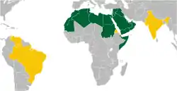
The Arab League is a regional organization of Arab states in Western Asia, North Africa, the Horn of Africa and the Indian Ocean. It covers a combined area of 13 million km². The League extends from Morocco in the west, southward to the Comoros, eastward to Somalia, and northward to Iraq.
 | |
| Continent | Asia and Africa |
|---|---|
| Area | Ranked 2nd |
| • Total | 13,333,296 km2 (5,148,014 sq mi) |
| Highest point | Jbel Toubkal 4,165 m[1] |
| Lowest point | Lac Assal −155 m[2] |
| Longest river | Nile 6,853 km |
| Part of a series on |
| Arab League |
|---|
 |
Regions
Terrains in the area can be divided into three main types: the large arid desert covering most of it, the fertile south and north, and finally the high mountains of the Atlas, Ahaggar, Zagros and the Anti-Lebanon mountains, along with the Hijaz Mountain range.
The Arab League can also be divided into two continental parts: Asian, which has 12 states, and African, which is larger and has 10 states. Adjacent to the League are 14 land neighbours and 4 sea neighbours. Geographically, the Arab League member states are further subdivided into four regions:
|
|
|
|
The Arab League has a high population density, with an estimated 350 million inhabitants. Culturally, the Arab states can be divided into 3 regions:
- The Greater Maghreb, which includes Morocco, Mauritania, Algeria, Tunisia and Libya.
- The Fertile Crescent, which includes Lebanon, Syria, Palestine, Egypt, Iraq and Jordan.
- The Arabian Peninsula, which includes Saudi Arabia, UAE, Qatar, Oman, Bahrain, Kuwait and Yemen.
Landscape
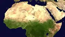
Most of the Arab League falls in the driest region of the world. Almost 80% of the Arab world is covered in desert (10,666,637 of 13,333,296 km2), stretching from Mauritania and Morocco to Oman and the UAE. The second most common terrain is the semi-arid terrain, which found in all Arab countries except Lebanon and Comoros.
Several deserts span the Arab League:
|
The highest point in the Arab League is in Morocco called Jbel Toubkal, standing 4,165m tall, making it the 40th highest place on earth, and 6th in Africa,[3] next comes Jabal an Nabi Shu'ayb (at 3,666 m)[3] in Yemen and Cheekha Dar (at 3,611 m)[4] in Iraq.
The lowest point in the Arab League is the Dead sea between Jordan and Palestine. At 1,312 feet (400 meters) below sea level it is also the lowest point on Earth.[5]
Climate
The hottest temperature recorded in the Arab League took place in Sudan on June 25, 2010, reaching 49.6 °C (121.3 °F) in Dongola, breaking a record set in 1987.[6]
References
- "Africa Ultra-Prominences" Peaklist.org. Retrieved 2012-01-14.
- Warren, John K. (23 February 2006). Evaporites: sediments, resources and hydrocarbons. Birkhäuser. p. 280. ISBN 978-3-540-26011-0. Retrieved 27 May 2011.
- "Arabian peninsula and Middle East" Peaklist.org. Retrieved 2011-11-20.
- "Cheekha Dar, Iraq/Iran" Peakbagger.com. Retrieved 2012-09-06.
- About: What is the lowest point in the world?
- Masters, Jeff. "NOAA: June 2010 the globe's 4th consecutive warmest month on record". Dr. Jeff Masters' WunderBlog. Weather Underground. Archived from the original on 2010-07-19.
| |||||||||
| Politics |
|  | |||||||
| Membership |
| ||||||||
| Diplomacy | |||||||||
| Life | |||||||||