Hampton Parish, New Brunswick
Hampton is a civil parish in Kings County, New Brunswick, Canada.[2]
Hampton | |
|---|---|
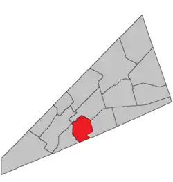 Location within Kings County, New Brunswick. | |
| Coordinates: 45.84°N 64.59°W | |
| Country | |
| Province | |
| County | Kings County |
| Erected | 1795 |
| Area | |
| • Land | 121.26 km2 (46.82 sq mi) |
| Population (2016)[1] | |
| • Total | 2,809 |
| • Density | 23.2/km2 (60/sq mi) |
| • Change 2011-2016 | |
| • Dwellings | 1,157 |
| Time zone | UTC-4 (AST) |
| • Summer (DST) | UTC-3 (ADT) |
For governance purposes it is divided between the towns of Hampton and Quispamsis and then local service district of the parish of Hampton, which further includes the service area of Fairmont Subdivision. Hampton and the LSD are members of Regional Service Commission 8 (RSC8), while Quispamsis is a member of the Fundy Regional Service Commission (FRSC).[3]
Origin of name
Ganong believed the name "perhaps" came from Hampton near London.[4] The name was common in the Thirteen Colonies.
History
Hampton was erected in 1795 from Sussex Parish and Kingston Parish.[5] It included Rothesay and Upham Parishes.
In 1835 Upham was erected as its own parish.[6]
In 1870 Rothesay was erected as its own parish.[7]
In 1873 the boundary with Rothesay was altered, specifying the path through the islands in the river and changing the mainland portion to follow grant lines rather than the road to Golden Grove.[8]
In 1897 the boundary with Upham was altered.[9]
Delineation
Hampton Parish is defined in the Territorial Division Act[2] as being bounded:
Northwesterly by the Kennebecasis River and Norton Parish; northeasterly by Norton and Upham Parishes; south by the County line; west by a line commencing at the junction of the Hammond River with the Kennebecasis River; thence along the eastern channel of Hammond River to an island lying between both branches of said river, and marked with the letters A, B, K and I in the grant made to widow Sarah Hunt and others, under the Great Seal of the Province of New Brunswick, bearing date the fifth day of March, one thousand seven hundred and eighty-seven; thence following a base line through said island, and also a base line through a larger adjoining island lying up stream marked C, D, E, F, G and H in said grant, which said lines are the dividing lines between lots number three, four, five and six, in the western division of lots in said grant, and also lots three, four, five and six in the eastern division of lots in said grant; thence following the said Hammond River up stream until it meets the eastern side line of the farm formerly occupied by Lorenzo D. Pierce, in the year one thousand eight hundred and seventy; thence along said line to the base line; thence along said base line until it strikes the eastern side line of the James McCullough farm; thence along that line to the County line, including Darlings Island.
Communities
Parish population total does not include incorporated municipalities (in bold).
|
|
|
Bodies of water & Islands
This is a list of rivers, lakes, streams, creeks, marshes and Islands that are at least partially in this parish
Demographics
Access Routes
Highways and numbered routes that run through the parish, including external routes that start or finish at the parish limits:[12]
See also
References
- "Census Profile, 2016 Census Hampton, Parish [Census subdivision], New Brunswick". Statistics Canada. Retrieved September 18, 2019.
- "Chapter T-3 Territorial Division Act". Government of New Brunswick. Retrieved 13 November 2020.
- "Communities in each of the 12 Regional Service Commissions (RSC) / Les communautés dans chacune des 12 Commissions de services régionaux (CSR)" (PDF), Government of New Brunswick, July 2017, retrieved 2 February 2021
- Ganong, William F. (1896). A Monograph of the Place-Nomenclature of the Province of New Brunswick. Royal Society of Canada. p. 239.
- "35 Geo. III c. 3 An Act in addition to an Act intitled, 'An Act for the better Ascertaining and Confirming the Boundaries of the several Counties within this Province, and for subdividing them into Towns or Parishes.'". Acts of the General Assembly of His Majesty's Province of New-Brunswick, Passed in the Year 1795. Fredericton: Government of New Brunswick. 1795. pp. 338–340.
- "5 Wm. IV c. 33 An Act to erect the North Eastern part of the Parish of Hampton in King's County into a separate and distinct Parish.". Acts of the General Assembly of His Majesty's Province of New-Brunswick, Passed in the Year 1835. Fredericton: Government of New Brunswick. 1835. p. 41.
- "33 Vic. c. 56 An Act to erect a part of the Parish of Hampton, in King's County, into a separate Town or Parish.". Acts of the General Assembly of Her Majesty's Province of New Brunswick Passed in the Months of March & April 1870. Fredericton: Government of New Brunswick. 1870. pp. 112–115.
- "36 Vic. c. 76 An Act to alter the division line between the Parishes of Hampton and Rothesay in the County of King's County.". Acts of the General Assembly of Her Majesty's Province of New Brunswick. Passed in the Months of March & April 1873. Fredericton: Government of New Brunswick. 1873. pp. 254–255.
- "60 Vic. c. 19 An Act to amend an Act intituled 'An Act to revise and codify an Act to provide for the Division of the Province into Counties, Towns and Parishes,' and to bettter [sic] define the bounds of the Parish of Upham.". Acts of the General Assembly of Her Majesty's Province of New Brunswick. Passed in the Month of March, 1897. Fredericton: Government of New Brunswick. 1897. p. 50.
- Statistics Canada: 2006 census
- 2011 Statistics Canada Census Profile: Hampton Parish, New Brunswick
- Atlantic Canada Back Road Atlas ISBN 978-1-55368-618-7
External links
Places adjacent to Hampton Parish, New Brunswick | |
|---|---|
| Subdivisions | |
|---|---|
| Cities | |
| Counties | |
| |
