Salisbury Parish, New Brunswick
Salisbury is a civil parish in Westmorland County, New Brunswick, Canada.[2]
Salisbury | |
|---|---|
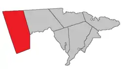 Location within Westmorland County, New Brunswick. | |
| Coordinates: 47.67°N 67.45°W | |
| Country | |
| Province | |
| County | Westmorland County |
| Erected | 1787 |
| Area | |
| • Land | 874.16 km2 (337.52 sq mi) |
| Population (2016)[1] | |
| • Total | 3,388 |
| • Density | 3.9/km2 (10/sq mi) |
| • Change 2011-2016 | |
| • Dwellings | 1,430 |
| Time zone | UTC-4 (AST) |
| • Summer (DST) | UTC-3 (ADT) |
For governance purposes it is divided between the villages of Petitcodiac and Salisbury;[3] the local service district of the parish of Salisbury,[4] and the special service area of Havelock Inside which extends from the LSD of the parish of Havelock.
All governance units are members of the Southeast Regional Service Commission.[5]
Origin of name
The origin of Salisbury's name is uncertain.
William F. Ganong states it was "perhaps" due to it extending nearly to Salisbury Bay,[6] a former name of Rocher Bay.[7]
The Provincial Archives of New Brunswick gives two possibilities: Sir John Salbusbury, who accompanied Edward Cornwallis on his mission to establish Nova Scotia; or Salisbury, a city in Wiltshire, England.[8]
History
Salisbury was erected in 1787 from unassigned land west of Hillsborough, Hopewell, and Moncton Parishes.[9]
In 1838 part of Salisbury was included in the newly erected Harvey Parish.[10]
In 1845 Albert County was erected from Westmorland County;[11] the county line ran through Salisbury.
In 1846 the county line with Albert was moved to its present location; the part of Salisbury south and east of the new line is transferred to Coverdale and Harvey Parishes.[12]
In 1894 the existing boundaries of Salisbury were declared retroactive to its erection.[13]
Delineation
Salisbury Parish is defined in the Territorial Division Act[2] as being bounded:
- North, west and south by the County lines; and east by Moncton Parish and the County of Albert.
Communities
Parish population total does not include incorporated municipalities (in bold):
|
|
|
Demographics
Population
|
LanguageMother tongue (2016)[1]
| |||||||||||||||||||||||||||||||||||||||
Access routes
Highways and numbered routes that run through the parish, including external routes that start or finish at the parish limits:[16]
See also
References
- "Census Profile, 2016 Census: Salisbury, Parish [Census subdivision], New Brunswick". Statistics Canada. Retrieved October 5, 2019.
- "Chapter T-3 Territorial Division Act". Government of New Brunswick. Retrieved 13 November 2020.
- "New Brunswick Regulation 85-6 under the Municipalities Act (O.C. 85-45)". Government of New Brunswick. Retrieved 23 July 2020.
- "New Brunswick Regulation 84-168 under the Municipalities Act (O.C. 84-582)". Government of New Brunswick. Retrieved 23 July 2020.
- "Communities in each of the 12 Regional Service Commissions (RSC) / Les communautés dans chacune des 12 Commissions de services régionaux (CSR)" (PDF), Government of New Brunswick, July 2017, retrieved 1 February 2021
- Ganong, William F. (1896). A Monograph of the Place-Nomenclature of the Province of New Brunswick. Royal Society of Canada. p. 270.
- "Salisbury Bay". Geographical names in Canada. Natural Resources Canada. Retrieved 23 October 2020.
- "Salisbury Parish". Provincial Archives of New Brunswick. Retrieved 23 October 2020.
- "27 Geo. III Chapter VII. An Act in Addition to an Act for the better ascertaining and confirming the Boundaries of the several Counties within this Province, and for Subdividing them into Towns or Parishes.". Acts of the General Assembly, of His Majesty's Province of New-Brunswick, Passed in the Year 1787. Saint John, New Brunswick: Government of New Brunswick. 1787. p. 147.
- "1 Vic. c. 23 An Act for erecting parts of the Towns or Parishes of Hopewell and Salisbury, in the County of Westmorland, into a separate Town or Parish.". Acts of the General Assembly of Her Majesty's Province of New Brunswick, Passed in the Year 1838. Fredericton: Government of New Brunswick. 1838. pp. 72–73.
- "8 Vic. c. 104 An Act to divide the County of Westmorland into two Counties, and to provide for the Government and Representation of the new County.". Acts of the General Assembly of Her Majesty's Province of New Brunswick, Passed in the Year 1846. Fredericton: Government of New Brunswick. 1846. pp. 150–152.
- "9 Vic. c. 7 An Act to alter the Division Line between the Counties of Westmorland and Albert, and also certain Parish Lines in the said County of Albert.". Acts of the General Assembly of Her Majesty's Province of New Brunswick, Passed in the Year 1846. Fredericton: Government of New Brunswick. 1846. pp. 20–21.
- "57 Vic. c. 36 An Act to amend Chapter 2 of the Consolidated Statutes, of 'The division of the Province into Counties, Towns and Parishes,' so far as relates to the County of Westmorland.". Acts of the General Assembly of Her Majesty's Province of New Brunswick. Passed in the Month of April, 1894. Fredericton: Government of New Brunswick. 1894. pp. 162–163.
- Statistics Canada: 2001, 2006 census
- 2011 Statistics Canada Census Profile: Salisbury Parish, New Brunswick
- Atlantic Canada Back Road Atlas ISBN 978-1-55368-618-7
Places adjacent to Salisbury Parish, New Brunswick | |
|---|---|
| Subdivisions | |
|---|---|
| Cities | |
| Counties | |
| |