Hawke's Bay Region
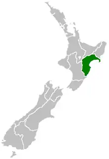
Hawke's Bay Region (Māori: Te Matau-a-Māui[3]) is a local government region of New Zealand on the east coast of the North Island. The region's name derives from Hawke Bay, which was named by Captain James Cook in honour of Admiral Edward Hawke. The region is governed by Hawke's Bay Regional Council.
| Hawke's Bay | |
| Country: | New Zealand |
 | |
| Regional council | |
|---|---|
| Name: | Hawke's Bay Regional Council |
| Seat: | Napier |
| Largest city: | Hastings |
| Population: | 178,600 June 2020[1] |
| Land area: | 14,111 km² |
| Chair: | Rex Graham |
| Deputy chair: | Rick Barker |
| HDI (2017) | 0.894[2] very high · 13th |
| Website: | http://www.hbrc.govt.nz/ |
| Cities and towns | |
| Cities: | Hastings • Napier |
| Towns and other settlements: | Bridge Pa • Clive • Frasertown • Haumoana • Mahia Beach • Maraekakaho • Nuhaka • Ocean Beach • Ongaonga • Ōtāne • Takapau • Te Awanga • Tikokino • Tuai • Tutira • Waimārama • Waipawa • Waipukurau • Wairoa |
| Territorial authorities | |
| Names: | Central Hawke's Bay Hastings District Napier City Wairoa District Rangitikei District (part) Taupo District (part) |
| Geographic figures | |
| Land area: | 14,111 km² |
| Coastline: | 360 km |
| Highest point: | Mount Mangaweka 1,733m |
| Longest river: | Mohaka River 174 km |
| Largest lake: | Lake Waikaremoana 54 km² |
Geography
The region is situated on the east coast of the North Island. It bears the former name of what is now Hawke Bay, a large semi-circular bay that extends for 100 kilometres from northeast to southwest from Mahia Peninsula to Cape Kidnappers.
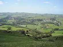
The Hawke's Bay Region includes the hilly coastal land around the northern and central bay, the floodplains of the Wairoa River in the north, the wide fertile Heretaunga Plains around Hastings in the south, and a hilly interior stretching up into the Kaweka and Ruahine Ranges. The prominent peak Taraponui is located inland.
Five major rivers flow to the Hawke's Bay coast. From north to south, they are the Wairoa River, Mohaka River, Tutaekuri River, Ngaruroro River and Tukituki River. Lake Waikaremoana, situated in northern Hawke's Bay, roughly 35 km from the coast, is the largest lake in Hawke's Bay, the 4th largest in the North Island and the 16th largest in New Zealand.
The regional council area consists of the territorial authorities of Wairoa District, Hastings District, Napier City, and its southernmost district, Central Hawke's Bay District, plus the localities of Taharua in the Taupo District and Ngamatea in the Rangitikei District. It does not include the Tararua District, Dannevirke, Woodville or Norsewood, which have been under the Manawatu-Wanganui Regional Council (also known as Horizons Regional Council) since the 1989 local government reforms.[4][5] In June 2015, the Local Government Commission proposed the amalgamation of the four territorial authorities in the region with the Hawke's Bay Regional Council,[6] but this was rejected in a poll of residents.[7]
The region has a hill with the longest place name in New Zealand, and the longest in the world according to the 2009 Guinness Book of Records. Taumatawhakatangihangakoauauotamateaturipukakapikimaungahoronukupokaiwhenuakitanatahu is an otherwise unremarkable hill in southern Hawke's Bay, not far from Waipukurau.
Demography
| Year | Pop. | ±% p.a. |
|---|---|---|
| 1991 | 138,342 | — |
| 1996 | 142,791 | +0.64% |
| 2001 | 142,950 | +0.02% |
| 2006 | 147,783 | +0.67% |
| 2013 | 151,179 | +0.33% |
| 2018 | 166,368 | +1.93% |
| Source: [8][9] | ||
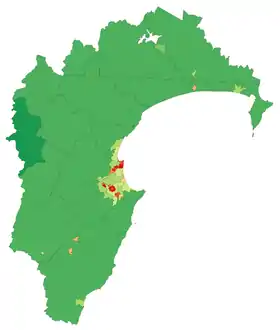
The region's population is 178,600 as of June 2020, 3.5 percent of New Zealand's population.[1] Around 74 percent of the region's population lives in the Napier-Hastings conurbation.
Hawke's Bay Region had a population of 166,368 at the 2018 New Zealand census, an increase of 15,189 people (10.0%) since the 2013 census, and an increase of 18,585 people (12.6%) since the 2006 census. There were 60,237 households. There were 81,054 males and 85,314 females, giving a sex ratio of 0.95 males per female. The median age was 40.6 years, with 34,935 people (21.0%) aged under 15 years, 29,202 (17.6%) aged 15 to 29, 71,841 (43.2%) aged 30 to 64, and 30,390 (18.3%) aged 65 or older.
Of those at least 15 years old, 21,417 (16.3%) people had a bachelor or higher degree, and 27,633 (21.0%) people had no formal qualifications. The median income was $28,300. The employment status of those at least 15 was that 63,999 (48.7%) people were employed full-time, 19,605 (14.9%) were part-time, and 4,710 (3.6%) were unemployed.[8]
Below is a list of urban areas that contain more than 1,000 population.
| Urban area | Population (June 2020)[1] |
% of region |
|---|---|---|
| Napier | 66,300 | 37.1% |
| Hastings | 49,000 | 27.4% |
| Havelock North | 14,900 | 8.3% |
| Wairoa | 4,870 | 2.7% |
| Waipukurau | 4,610 | 2.6% |
| Clive | 2,360 | 1.3% |
| Waipawa | 2,250 | 1.3% |
Other towns and settlements in Hawke's Bay include:
Culture and identity
Ethnicities in the 2018 census were 75.0% European/Pākehā, 27.0% Māori, 5.6% Pacific peoples, 5.0% Asian, and 1.7% other ethnicities. People may identify with more than one ethnicity.
The percentage of people born overseas was 15.9, compared with 27.1% nationally.
Although some people objected to giving their religion, 48.5% had no religion, 37.4% were Christian, and 7.2% had other religions.[8]
The major local Māori tribe is Ngāti Kahungunu.
History

Bay whaling stations operated on the shores of the bay in the nineteenth century.[10]
Hawke's Bay Province was founded in 1858 as a province of New Zealand, after being separated from the Wellington Province following a meeting in Napier in February 1858. The Province was abolished in 1876 along with all other provinces in New Zealand. It was replaced with a Provincial District.
On February 3, 1931, Napier and Hastings were devastated by New Zealand's worst natural disaster, an earthquake measuring 7.9 on the Richter magnitude scale, which killed 256 people. Napier rebuilt and now the city is world-famous for its Art Deco buildings, and celebrates its heritage each February with the Art Deco Weekend. MTG Hawke's Bay, formerly Hawke's Bay Museum and Art Gallery, has an exhibition on the earthquake, its causes and impact.
Economy
The subnational gross domestic product (GDP) of Hawke's Bay was estimated at NZ$8.67 billion in the year to March 2019, 2.9% of New Zealand's national GDP. The regional GDP per capita was estimated at $50,251 in the same period. In the year to March 2018, primary industries contributed $1.14 billion (13.9%) to the regional GDP, goods-producing industries contributed $1.84 billion (22.3%), service industries contributed $4.56 billion (55.3%), and taxes and duties contributed $707 million (8.6%).[11]
Agriculture
The region is renowned for its horticulture, with large orchards and vineyards on the plains. In the hilly parts of the region sheep and cattle farming predominates, with forestry blocks in the roughest areas.
Hawke's Bay has 17,886 ha (44,200 acres) of horticultural land, the third largest area in New Zealand behind Canterbury and Marlborough. The largest crops by land area are apples (4,750 ha), wine grapes (3,620 ha), squash (3,390 ha), and peas and beans (1,360 ha).[12]
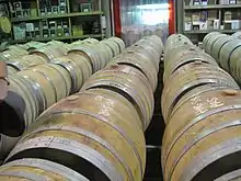
Wine
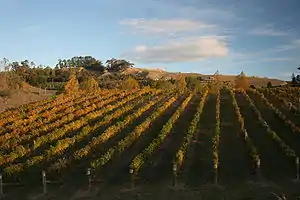
The climate is dry and temperate, and the long, hot summers and cool winters offer excellent weather for growing grapes. Missionaries in the mid 19th century planted the first vines in Hawke's Bay and it is now an important place for full bodied red wines.[13] The wine region is the second largest after the Marlborough wine region, with 4,681 hectares (11,570 acres) of vineyards and 91 operating wineries in 2018.[14]
Aerospace
Hawke's Bay is home to Rocket Lab's Launch Complex 1, New Zealand's first orbital launch site, on Mahia Peninsula. Wairoa District is home to Space Coast New Zealand, a stretch of coastline from which space launches can be viewed.[15] Rocket Lab launches its Electron rockets several times a year, after its first successful launch of Humanity Star in January 2018.
Seismicity
Hawke's Bay is one of the most seismically active regions in New Zealand and has experienced many large and often damaging earthquakes. More than 50 damaging earthquakes have been recorded in the region since the 1800s.
| Date | Location | Magnitude (ML) | Depth | Fatalities | More information |
|---|---|---|---|---|---|
| 8 Jul 1843 | 25 km west of Tikokino | 7.6 | 12 km | 2 | [16] |
| 22 Feb 1863 | Waipukurau | 7.5 | 25 km | 1863 Hawke's Bay earthquake [17] | |
| 14 Sep 1875 | Mahia Peninsula | 5.8 | 25 km | [18] | |
| 9 Aug 1904 | Porangahau | 7.0 | 16 km | [19] | |
| 28 Jun 1921 | Kaweka Forest Park | 6.7 | 80 km | [20] | |
| 12 Feb 1930 | Porangahau | 6.2 | 33 km | [21] | |
| 3 Feb 1931 | 20 km north of Napier | 7.8 | 20 km | 256 | 1931 Hawke's Bay earthquake [22] |
| 3 Feb 1931 | 25 km north east of Napier | 5.8 | 25 km | [23] | |
| 8 Feb 1931 | Wairoa | 6.4 | 60 km | [24] | |
| 13 Feb 1931 | 50 km east of Napier | 7.3 | 30 km | [25] | |
| 5 May 1932 | 50 km east of Napier | 5.9 | 12 km | [26] | |
| 16 Sep 1932 | Wairoa | 6.9 | 12 km | [27] | |
| 5 Mar 1934 | Pongaroa | 7.2 | 12 km | [28] | |
| 15 Mar 1934 | Wairoa | 6.3 | 25 km | [29] | |
| 26 Feb 1940 | Hastings | 6.0 | 25 km | [30] | |
| 1 Mar 1950 | Lake Waikaremoana | 5.8 | 60 km | [31] | |
| 10 Feb 1951 | Porangahau | 6.2 | 33 km | [32] | |
| 6 Oct 1980 | Hastings | 5.7 | 30 km | [33] | |
| 19 Feb 1990 | Porangahau | 6.2 | 34 km | [34] | |
| 13 May 1990 | Porangahau | 6.4 | 30 km | [35] |
Council
The region is governed by Hawke's Bay Regional Council, which has its main office and council chamber in Napier. The council consists of nine elected members and holds elections every three years. As of the 2019 election the council is:
| Member(s) | Constituency |
|---|---|
| Rex Graham - Chair | Hastings |
| Rick Barker - Deputy Chair | Hastings |
| Hinewai Ormsby | Napier |
| Craig Foss | Hastings |
| Charles Lambert | Wairoa |
| Will Foley | Central Hawke's Bay |
| Jerf van Beek | Ngaruroro |
| Neil Kirton | Napier |
| Martin Williams | Napier |
Culture
The region is served by a variety of radio stations including Radio Kahungunu, The Hits 89.5, More FM, access station Radio Kidnappers and local station Bay FM. As well, most of the national commercial and non-commercial operators have transmitters covering the region. Hawke's Bay also has its own TV station, TVHB, which provides a mix of news and information programmes hosted by local personalities.
The Hawke's Bay wine region produces some of New Zealand's finest wines, celebrated together with local cuisine twice a year with the Food And Wine Classic festivals. These take place over several weekends in winter and ten days in summer, attracting thousands of visitors, many from overseas.[36]
Napier is home to the Mission Concert held early each year since 1993. The event, held at the Mission Estate Winery in Taradale, has attracted performers such as Kenny Rogers, Shirley Bassey, Rod Stewart, The B-52's, Belinda Carlisle, Ray Charles, and Eric Clapton. The 2009 concert attraction was to be Lionel Richie, but the concert was cancelled because of rain.
UK music artist Tycho Jones was staying in Hastings, Hawkes Bay when he was inspired to write the track Don't Be Afraid, produced by Jonathan Quarmby.[37]
Sport
As throughout New Zealand, rugby union is the most popular sport. The Hawke's Bay Magpies play in New Zealand's annual professional domestic rugby union competition, the Mitre 10 Cup. The team represents the Hawke's Bay Region in provincial representative rugby, and draws its players from the constituent clubs who are affiliated to the provincial union. The team play their home matches in McLean Park in Napier. Players representing Hawke's Bay are also eligible to play for the Hurricanes in the annual transnational Super Rugby competition. Hawke's Bay has produced a number of notable All Blacks, including:
- Cyril Brownlie
- Maurice Brownlie
- Mark Donaldson
- Bryn Evans
- Greg Somerville
- Hikawera Elliot
- Zac Guildford
- Israel Dagg.
The Hawke's Bay Hawks compete in the New Zealand National Basketball League.
References
- "Population estimate tables - NZ.Stat". Statistics New Zealand. Retrieved 22 October 2020.
- "Sub-national HDI - Area Database - Global Data Lab". hdi.globaldatalab.org. Retrieved 13 September 2018.
- Pollock, Kerryn. 'Hawke’s Bay region - Overview'. Te Ara - the Encyclopedia of New Zealand. (accessed 9 November 2017)
- Pollock, Kerryn (15 November 2012). "Hawke's Bay region – Local government boundary changes". Te Ara – the Encyclopedia of New Zealand.
- Pollock, Kerryn (15 November 2012). "Hawke's Bay region – Government, education and health". Te Ara – the Encyclopedia of New Zealand.
- Lunn, Annette (9 June 2015). "Hawke's Bay to amalgamate councils". Newstalk ZB.
- Henderey, Simon (15 September 2015). "Hawke's Bay voters reject five-council amalgamation proposal". The Dominion Post. Retrieved 23 March 2019.
- "Statistical area 1 dataset for 2018 Census". Statistics New Zealand. March 2020. Hawke's Bay Region (06). 2018 Census place summary: Hawke's Bay Region
- "2001 Census: Regional summary". archive.stats.govt.nz. Retrieved 28 April 2020.
- Don Grady (1986) Sealers & whalers in New Zealand waters, Auckland, Reed Methuen, p.150. ISBN 0474000508
- "Regional gross domestic product: Year ended March 2019 | Stats NZ". www.stats.govt.nz. Retrieved 21 May 2020.
- "Fresh Facts: New Zealand Horticulture" (PDF). Plant & Food Research. 2018. ISSN 1177-2190.
- The-Wine-Library Archived 5 October 2011 at the Wayback Machine Short Description of wine in Hawkes Bay
- "New Zealand Winegrowers Annual Report 2018" (PDF). New Zealand Winegrowers. 2018. Retrieved 5 August 2019.
- "Space Coast New Zealand". Wairoa District Council. Retrieved 8 August 2019.
- "A magnitude 7.6 earthquake occurred 35 km east of Taihape, New Zealand on Sat Jul 8 1843 5:09 PM. The quake was 12 kilometres deep and the shaking was severe close to the quake".
- "A magnitude 7.5 earthquake occurred Within 5 km of Waipukurau, New Zealand on Mon Feb 23 1863 12:39 AM. The quake was 25 kilometres deep and the shaking was severe close to the quake".
- "A magnitude 5.8 earthquake occurred 35 km south of Gisborne, New Zealand on Tue Sep 14 1875 11:39 PM. The quake was 25 kilometres deep and the shaking was strong close to the quake".
- "A magnitude 7.0 earthquake occurred 20 km south-west of Porangahau, New Zealand on Tue Aug 9 1904 10:20 AM. The quake was 16 kilometres deep and the shaking was severe close to the quake".
- "A magnitude 6.7 earthquake occurred 45 km north-west of Napier, New Zealand on Wed Jun 29 1921 1:28 AM. The quake was 80 kilometres deep and the shaking was severe close to the quake".
- "A magnitude 6.2 earthquake occurred 10 km south-west of Porangahau, New Zealand on Wed Feb 12 1930 6:22 PM. The quake was 33 kilometres deep and the shaking was severe close to the quake".
- "GeoNet News". info.geonet.org.nz.
- "A magnitude 5.8 earthquake occurred 20 km north of Napier, New Zealand on Tue Feb 3 1931 8:41 PM. The quake was 25 kilometres deep and the shaking was strong close to the quake".
- "A magnitude 6.4 earthquake occurred 15 km south-east of Wairoa, New Zealand on Sun Feb 8 1931 1:44 PM. The quake was 60 kilometres deep and the shaking was severe close to the quake".
- "A magnitude 7.3 earthquake occurred 50 km south of Wairoa, New Zealand on Fri Feb 13 1931 1:27 PM. The quake was 30 kilometres deep and the shaking was severe close to the quake".
- "A magnitude 5.9 earthquake occurred 45 km east of Napier, New Zealand on Thu May 5 1932 7:54 PM. The quake was 12 kilometres deep and the shaking was strong close to the quake".
- "A magnitude 6.9 earthquake occurred 15 km north-east of Wairoa, New Zealand on Fri Sep 16 1932 1:25 AM. The quake was 12 kilometres deep and the shaking was severe close to the quake".
- "A magnitude 7.2 earthquake occurred 5 km east of Pongaroa, New Zealand on Mon Mar 5 1934 11:46 PM. The quake was 12 kilometres deep and the shaking was severe close to the quake".
- "A magnitude 6.3 earthquake occurred 30 km south-west of Wairoa, New Zealand on Thu Mar 15 1934 10:46 PM. The quake was 25 kilometres deep and the shaking was severe close to the quake".
- "A magnitude 6.0 earthquake occurred 30 km north-west of Hastings, New Zealand on Mon Feb 26 1940 6:16 PM. The quake was 25 kilometres deep and the shaking was strong close to the quake".
- "A magnitude 5.8 earthquake occurred 45 km north-west of Wairoa, New Zealand on Wed Mar 1 1950 6:58 AM. The quake was 60 kilometres deep and the shaking was moderate close to the quake".
- "A magnitude 6.2 earthquake occurred 35 km east of Porangahau, New Zealand on Sat Feb 10 1951 3:27 PM. The quake was 33 kilometres deep and the shaking was strong close to the quake".
- "A magnitude 5.7 earthquake occurred 5 km south of Hastings, New Zealand on Mon Oct 6 1980 3:32 AM. The quake was 30 kilometres deep and the shaking was strong close to the quake".
- "A magnitude 6.2 earthquake occurred 20 km north-east of Pongaroa, New Zealand on Mon Feb 19 1990 6:34 PM The quake was 34 kilometres deep and the shaking was severe close to the quake".
- "A magnitude 6.4 earthquake occurred 15 km south-west of Porangahau, New Zealand on Sun May 13 1990 4:23 PM. The quake was 30 kilometres deep and the shaking was severe close to the quake".
- Harfield, Ruby (13 November 2017). "Newcomers flock to 10-day Hawke's Bay Food and Wine Classic F.A.W.C!". Hawke's Bay Today. Retrieved 8 August 2019.
- Sawyer, Jack (9 May 2020). "Tycho Jones delivers on single-run finale with 'Don't Be Afraid' & Tychonaut EP". Musical Motif.
External links
| Wikimedia Commons has media related to Hawke's Bay Region. |
| Wikivoyage has a travel guide for Hawke's Bay. |
- Hawke's Bay Regional Council
- Official Hawke's Bay Tourism Portal
- Official Newcomers website - free information service for newcomers to Hawke's Bay
- "Hawke's Bay Province and Provincial District". An Encyclopaedia of New Zealand, edited by A. H. McLintock, Wellington, 1966
| North Island | ||
|---|---|---|
| South Island | ||
* Governed by a unitary authority rather than a regional council | ||