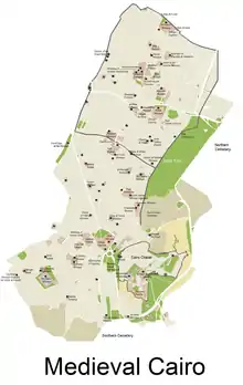
Islamic Cairo
Islamic Cairo (Arabic: قاهرة المعز, meaning: Al-Mu'izz's Cairo), also called Historic Cairo or Medieval Cairo, refers generically to the historic areas of Cairo, Egypt, that existed before the city's modern expansion during the 19th and 20th centuries; particularly the central parts around the old walled city and around the Citadel of Cairo. The name "Islamic" Cairo refers not to a greater prominence of Muslims in the area but rather to the city's rich history and heritage since its foundation in the early period of Islam, while distinguishing it from with the nearby Ancient Egyptian sites of Giza and Memphis.[1][2] This area holds one of the largest and densest concentrations of historic architecture in the Islamic world.[1]:7 It is characterized by hundreds of mosques, tombs, madrasas, mansions, caravanserais, and fortifications dating from throughout the Islamic era of Egypt. In 1979, the United Nations Educational, Scientific and Cultural Organization (UNESCO) proclaimed Historic Cairo a World Cultural Heritage site, as "one of the world's oldest Islamic cities, with its famous mosques, madrasas, hammams and fountains" and "the new centre of the Islamic world, reaching its golden age in the 14th century."[3]
| UNESCO World Heritage Site | |
|---|---|
 | |
| Location | Cairo Governorate, Egypt |
| Includes |
|
| Criteria | Cultural: (i), (v), (vi) |
| Reference | 89 |
| Inscription | 1979 (3rd session) |
| Area | 523.66 ha (1,294.0 acres) |
| Coordinates | 30°02′45.61″N 31°15′45.78″E |
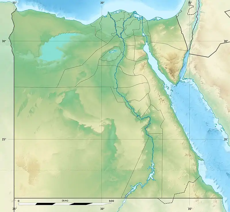 Location of Islamic Cairo in Egypt | |
History
The foundation of Fustat and the early Islamic era
_(3278025469).jpg.webp)
The history of Cairo begins, in essence, with the conquest of Egypt by Muslim Arabs in 640, under the commander 'Amr ibn al-'As.[4] Although Alexandria was the capital of Egypt at that time (and had been throughout the Ptolemaic, Roman, and Byzantine periods), the Arab conquerors decided to establish a new city called Fustat to serve as the administrative capital and military garrison center of Egypt. The new city was located near a Roman-Byzantine fortress known as Babylon on the shores of the Nile (now located in Old Cairo), southwest of the later site of Cairo proper (see below). The choice of this location may have been due to several factors, including its slightly closer proximity to Arabia and Mecca, the fear of strong remaining Christian and Hellenistic influence in Alexandria, and Alexandria's vulnerability to Byzantine counteroffensives arriving by sea (which did indeed occur).[4][5] Perhaps even more importantly, the location of Fustat at the intersection of Lower Egypt (the Nile Delta) and Upper Egypt (the Nile Valley further south) made it a strategic place from which to control a country that was centered on the Nile river, much as the Ancient Egyptian city of Memphis (located just south of Cairo today) had done.[4][5] (The pattern of founding new garrison cities inland was also one that was repeated throughout the Arab conquests, with other examples such as Qayrawan in Tunisia or Kufa in Iraq.[5]) The foundation of Fustat was also accompanied by the foundation of Egypt's (and Africa's) first mosque, the Mosque of 'Amr ibn al-'As, which has been much rebuilt over the centuries but still exists today.[1]
Fustat quickly grew to become Egypt's main city, port, and economic center, with Alexandria becoming more of a provincial city.[5] In 661 the Islamic world came under the control of the Ummayyads, based in their capital at Damascus, until their overthrow by the Abbasids in 750. The last Ummayyad caliph, Marwan II, made his last stand in Egypt but was killed on August 1st, 750.[4] Thereafter Egypt, and Fustat, passed under Abbasid control. The Abbasids marked their new rule in Egypt by founding a new administrative capital called al-'Askar, slightly northeast of Fustat, under the initiative of their governor Abu 'Aun. The city was completed with the foundation of a grand mosque (called Jami' al-'Askar) in 786, and included a palace for the governor's residence, known as the Dar al-'Imara.[4] Nothing of this city remains today, but the foundation of new administrative capitals just outside the main city became a recurring pattern in the history of the area.
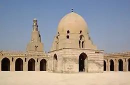
Ahmad Ibn Tulun was a Turkish military commander who had served the Abbasid caliphs in Samarra during a long crisis of Abbasid power.[6] He became governor of Egypt in 868 but quickly became its de facto independent ruler, while still acknowledging the Abbasid caliph's symbolic authority. He grew so influential that the caliph later allowed him to also take control of Syria in 878.[4] During this period of Tulunid rule (under Ibn Tulun and his sons), Egypt became an independent state for the first time since Roman rule was established in 30 BC.[4] Ibn Tulun founded his own new administrative capital in 870, called al-Qata'i, just northwest of al-Askar. It included a new grand palace (still called Dar al-'Imara), a hippodrome or military parade ground, amenities such as a hospital (bimaristan), and a great mosque which survives to this day, known as the Mosque of Ibn Tulun, built between 876 and 879.[6][4] Ibn Tulun died in 884 and his sons ruled for a few more decades until 905 when the Abbasids sent an army to reestablish direct control and burned al-Qata'i to the ground, sparing only the mosque.[4] After this, Egypt was ruled for a while by another dynasty, the Ikhshidids, who ruled as Abbasid governors between 935 and 969. Some of their constructions, particularly under Abu al-Misk Kafur, a black eunuch (originally from Ethiopia) who ruled as regent during the later part of this period, may have influenced the future Fatimids' choice of location for their capital, since one of Kafur's great gardens along the Khalij canal was incorporated into the later Fatimid palaces.[4]
The founding of al-Qahira (Cairo) and the Fatimid period
_2006.jpg.webp)
The Fatimids, an Isma'ili Shi'a caliphate which was based in Ifriqiya (Tunisia), conquered Egypt in 969 CE during the reign of Caliph al-Mu'izz. Their army, composed mostly of North African Kutama Berbers, was led by the general Jawhar al-Siqilli. In 970, under instructions from al-Mu'izz, Jawhar planned, founded, and constructed a new city to serve as the residence and center of power for the Fatimid Caliphs. The city was named al-Mu'izziyya al-Qaahirah, the "Victorious City of al-Mu'izz", later simply called "al-Qahira", which gave us the modern name of Cairo.[7]:80
The city was located northeast of Fustat and of the previous administrative capitals built by Ibn Tulun and the Abbasids. Jawhar organized the new city so that at its center were the Great Palaces that housed the caliphs, their household, and the state's institutions.[4] Two main palaces were completed: an eastern one (the largest of the two) and a western one, between which was an important plaza known as Bayn al-Qasrayn ("Between the Two Palaces"). The city's main mosque, the Mosque of al-Azhar, was founded in 972 as both a Friday mosque and as a center of learning and teaching, and is today considered one of the oldest universities in the world.[1] The city's main street, known today as Al-Mu'izz li-Din Allah Street (or al-Mu'zz street) but historically referred to as the Qasabah or Qasaba, ran from one of the northern city gates (Bab al-Futuh) to the southern gate (Bab Zuweila) and passed between the palaces via Bayn al-Qasrayn. Under the Fatimids, however, Cairo was a royal city which was closed to the common people and inhabited only by the Caliph's family, state officials, army regiments, and other people necessary to the operations of the regime and its city. Fustat remained for some time the main economic and urban center of Egypt. It was only later that Cairo grew to absorb other local cities, including Fustat, but the year 969 is sometimes considered the "founding year" of the current city.[8]
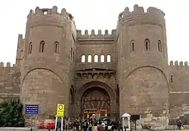
Al-Mu'izz, and with him the administrative apparatus of the Fatimid Caliphate, left his former capital of Mahdia, Tunisia, in 972 and arrived in Cairo in June 973.[7][4] The Fatimid Empire quickly grew powerful enough to stand as a threat to the rival Sunni Abbasid Caliphate. During the reign of Caliph al-Mustansir (1036-1094), the longest of any Muslim ruler, the Fatimid Empire reached its peak but also began its decline.[9] A few strong viziers, acting on behalf of the caliphs, managed to revive the empire's power on occasion. The Armenian vizier Badr al-Jamali (in office from 1073-1094) notably rebuilt the walls of Cairo in stone, with monumental gates, the remains of which still stand today and were expanded under later Ayyubid rule.[4] The late 11th century was also a time of major events and developments in the region. It was at this time that the Great Seljuk (Turkish) Empire took over much of the eastern Islamic world. The arrival of the Turks, who were mainly Sunni Muslims, was a long-term factor in the so-called "Sunni Revival" which reversed the advance of the Fatimids and of Shi'a factions in the Middle East.[10] In 1099 the First Crusade captured Jerusalem, and the new Crusader states became a sudden and serious threat to Egypt. New Muslim rulers such as Nur al-Din of the Turkish Zengid dynasty took charge of the overall offensive against the Crusaders.
In the 12th century the weakness of the Fatimids became so severe that under the last Fatmid Caliph, al-'Adid, they requested help from the Zengids to protect themselves from the King of Jerusalem, Amalric, while at the same time attempting to collude with the latter to keep the Zengids in check.[7] In 1168, as the Crusaders marched on Cairo, the Fatimid vizier Shawar, worried that the unfortified city of Fustat would be used as a base from which to besiege Cairo, ordered its evacuation and then set the city ablaze. While historians debate the extent of the destruction (as Fustat appears to have continued to exist after this), the burning of Fustat nonetheless marks a pivotal moment in the decline of that city, which was later eclipsed by Cairo itself.[4][11] Eventually, Salah ad-Din (Saladin), a Zengid commander who was given the position of al-'Adid's vizier in Cairo, declared the end and dismantlement of the Fatimid Caliphate in 1171. Cairo thus returned to Sunni rule, and a new chapter in the history of Egypt, and of Cairo's urban history, opened.
Cairo's ascendance in the Ayyubid and Mamluk periods
.jpg.webp)
.jpg.webp)
Salah ad-Din's reign marked the beginning of the Ayyubid dynasty, which ruled over Egypt and Syria and carried forward the fight against the Crusaders. He also embarked on the construction of an ambitious new fortified Citadel (the current Citadel of Cairo) further south, outside the walled city, which would house Egypt's rulers and state administration for many centuries thereafter. This ended Cairo's status as an exclusive palace-city and started a process by which the city became an economic center inhabited by common Egyptians and open to foreign travelers.[11] Over the subsequent centuries, Cairo developed into a full-scale urban center. The decline of Fustat over the same period paved the way for its ascendance. The Ayyubid sultans and their Mamluk successors, who were Sunni Muslims eager to erase the influence of the Shi'a Fatimids, progressively demolished and replaced the great Fatimid palaces with their own buildings.[4] The Al-Azhar Mosque was converted to a Sunni institution, and today it is the foremost center for the study of the Qur'an and Islamic law in the Sunni Islamic world.[1]
In 1250 the Ayyubid dynasty faltered and power transitioned to a regime controlled by the Mamluks. The mamluks were soldiers who were purchased as young slaves (often from various regions of Central Eurasia) and raised to serve in the army of the sultan. They became a mainstay of the Ayyubid military under Sultan al-Salih and eventually became powerful enough to assume control of the state for themselves in a political crisis during the Seventh Crusade. Between 1250 and 1517, the throne passed from one mamluk to another in a system of succession that was generally non-hereditary, but also frequently violent and chaotic. Nonetheless, the Mamluk Empire continued many aspects of the Ayyubid Empire before it, and was responsible for repelling the advance of the Mongols in 1260 (most famously at the Battle of Ain Jalut) and for putting a final end to the Crusader states in the Levant.[12]
Under the reign of the Mamluk sultan al-Nasir Muhammad (1293-1341, including interregnums), Cairo reached its apogee in terms of population and wealth.[4] A commonly-cited estimate of the population towards the end of his reign, although difficult to evaluate, gives a figure of about 500,000, making Cairo the largest city in the world outside China at the time.[13][14] Despite being a largely military caste, the Mamluks were prolific builders and sponsors of religious and civic buildings. An extensive number of Cairo's historical monuments date from their era, including many of the most impressive.[4][1] The city also prospered from the control of trade routes between the Indian Ocean and the Mediterranean.[4] After the reign of al-Nasir, however, Egypt and Cairo were struck by repeated epidemics of the plague, starting with the Black Death in the mid-14th century. Cairo's population declined and took centuries to recover, but it remained the major metropolis of the Middle East.[4]
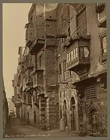
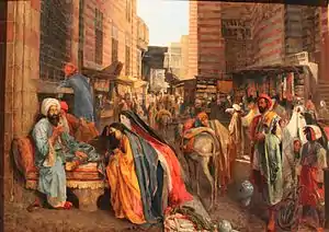
Under the Ayyubids and the later Mamluks, the Qasaba avenue became a privileged site for the construction of religious complexes, royal mausoleums, and commercial establishments, usually sponsored by the sultan or members of the ruling class. This is also where the major souqs of Cairo developed, forming its main economic zone of international trade and commercial activity.[4][1] As the main street became saturated with shops and space for further development there ran out, new commercial structures were built further east, close to al-Azhar Mosque and to the shrine of al-Hussein, where the souq area of Khan al-Khalili, still present today, progressively developed.[11] One important factor in the development of Cairo's urban character was the growing number of waqf establishments, especially during the Mamluk period. Waqfs were charitable trusts under Islamic law which set out the function, operations, and funding sources of the many religious/civic establishments built by the ruling elite. They were typically drawn up to define complex religious or civic buildings which combined various functions (e.g. mosque, madrasa, mausoleum, sebil) and which were often funded with revenues from urban commercial buildings or rural agricultural estates.[15] By the late 15th century Cairo also had high-rise mixed-use buildings (known as a rab', a khan or a wikala, depending on exact function) where the two lower floors were typically for commercial and storage purposes and the multiple stories above them were rented out to tenants.[16]
Cairo as a provincial capital of the Ottoman Empire
Egypt was conquered by the Ottoman Empire in 1517, under Selim I, and remained under Ottoman rule for centuries. During this period, local elites fought ceaselessly among themselves for political power and influence; some of them of Ottoman origin, others from the Mamluk caste which continued to exist as part of the country's elites despite the demise of the Mamluk sultanate.[4]
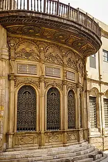
Cairo continued to be a major economic center and one of the empire's most important cities. It remained the principal staging point for the pilgrimage (Hajj) route to Mecca.[4] While the Ottoman governors were not major patrons of architecture like the Mamluks, Cairo nonetheless continued to develop and new neighbourhoods did grow outside the old city walls.[4][1] Ottoman architecture in Cairo continued to be heavily influenced and derived from the local Mamluk-era traditions rather than presenting a clear break with the past.[1] Some individuals, such as Abd ar-Rahman Katkhuda al-Qazdaghli, a mamluk official among the Janissaries in the 18th century, were prolific architectural patrons.[4][1] Many old bourgeois or aristocratic mansions that have been preserved in Cairo today date from the Ottoman period, as do a number of sabil-kuttabs (a combination of water distribution kiosk and Qur'anic reading school).[1]
Cairo under Muhammad Ali Pasha and the Khedives
Napoleon's French army briefly occupied Egypt from 1798 to 1801, after which an Albanian officer in the Ottoman army named Muhammad Ali Pasha made Cairo the capital of an independent empire that lasted from 1805 to 1882. The city then came under British control until Egypt was granted its independence in 1922.
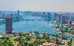
Under Muhammad Ali's rule the Citadel of Cairo was completely refurbished. Many of its disused Mamluk monuments were demolished to make way for his new mosque (the Mosque of Muhammad Ali) and other palaces. Muhammad Ali's dynasty also introduced a more purely Ottoman style of architecture, mainly in the late "Ottoman Baroque" style of the time.[1] One of his grandsons, Isma'il, as Khedive between 1864 and 1879, oversaw the construction of the modern Suez Canal. Along with this enterprise, he also undertook the construction of a vast new city in European style to the north and west of the historic center of Cairo. The new city emulated Haussman's 19th-century reforms of Paris, with grand boulevards and squares being part of the planning and layout.[4] Although never fully completed to the extent of Isma'il's vision, this new city composes much of Downtown Cairo today. This left the old historic districts of Cairo, including the walled city, relatively neglected. Even the Citadel lost its status as the royal residence when Isma'il moved to the new Abdin Palace in 1874.[1]
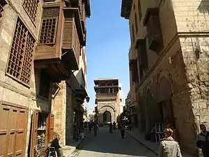
Historic sites and monuments
.jpg.webp)
Mosques
While the first mosque in Egypt was the Mosque of Amr ibn al-As in Fustat, the Mosque of Ibn Tulun is the oldest mosque to retain its original form and is a rare example of Abbasid architecture, from the classical period of Islamic civilization. It was built in 876–879 AD in a style inspired by the Abbasid capital of Samarra in Iraq.[1] It is one of the largest mosques in Cairo and is often cited as one of the most beautiful.[1][17]
One of the most important and lasting institutions founded in the Fatimid period was the Mosque of al-Azhar, founded in 970 AD, which competes with the Qarawiyyin in Fes for the title of oldest university in the world.[1] Today, al-Azhar University is the foremost center of Islamic learning in the world and one of Egypt's largest universities with campuses across the country.[1] The mosque itself retains significant Fatimid elements but has been added to and expanded in subsequent centuries, notably by the Mamluk sultans Qaitbay and al-Ghuri and by Abd al-Rahman Katkhuda in the 18th century. Other extant monuments from the Fatimid era include the large Mosque of al-Hakim, the al-Aqmar mosque, Juyushi Mosque, Lulua Mosque, and the Mosque of Salih Tala'i.
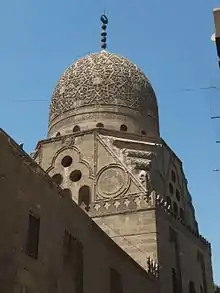
The most prominent architectural heritage of medieval Cairo, however, dates from the Mamluk period, from 1250 to 1517 AD. The Mamluk sultans and elites were eager patrons of religious and scholarly life, commonly building religious or funerary complexes whose functions could include a mosque, madrasa, khanqah (for Sufis), water distribution centers (sabils), and mausoleum for themselves and their families.[15] Among the best-known examples of Mamluk monuments in Cairo are the huge Mosque-Madrasa of Sultan Hasan, the Mosque of Amir al-Maridani, the Mosque of Sultan al-Mu'ayyad (whose twin minarets were built above the gate of Bab Zuwayla), the Sultan Al-Ghuri complex, the funerary complex of Sultan Qaytbay in the Northern Cemetery, and the trio of monuments in the Bayn al-Qasrayn area comprising the complex of Sultan al-Mansur Qalawun, the Madrasa of al-Nasir Muhammad, and the Madrasa of Sultan Barquq. Some mosques include spolia (often columns or capitals) from earlier buildings built by the Romans, Byzantines, or Copts.[1]
Shrines and mausoleums
Islamic Cairo is also the location of several important religious shrines such as the al-Hussein Mosque (whose shrine is believed to hold the head of Husayn ibn Ali), the Mausoleum of Imam al-Shafi'i (founder of the Shafi'i madhhab, one of the primary schools of thought in Sunni Islamic jurisprudence), the Tomb of Sayyida Ruqayya, the Mosque of Sayyida Nafisa, and others.[1] Some of these shrines are located within the vast cemetery areas known as the City of the Dead or al-Qarafa in Arabic, which adjoin the historic city. The cemeteries date back to the foundation of Fustat, but many of the most prominent and famous mausoleum structures are from the Mamluk era.[18]
Walls and gates
When Cairo was founded as palace-city in 969 by the Fatimids, it was enclosed by a circuit of walls. These were rebuilt in stone in the late 11th century AD by the vizir Badr al-Gamali, parts of which survive today at Bab Zuwayla in the south and Bab al-Futuh and Bab al-Nasr in the north.[4][1] The walls were extended and modified by the Ayyubids as part of Salah ad-Din's ambitious plan to protect both Cairo and Fustat by a single set of walls. Parts of these walls were recently excavated next to al-Azhar Park, including some Ayyubid gates like Bab al-Barqiya.[1]
Citadel
Salah ad-Din (Saladin) began the construction of an extensive Citadel in 1176 to serve as Egypt's seat of power, with construction finishing under his successors.[19] It is located on a promontory of the nearby Muqattam Hills overlooking the city. The Citadel remained the residence of the rulers of Egypt until the late 19th century, and was repeatedly transformed under subsequent rulers. Notably, Muhammad Ali Pasha built the 19th-century Mosque of Muhammad Ali which still dominates the city's skyline from its elevated vantage point.[1]
Markets and commercial buildings
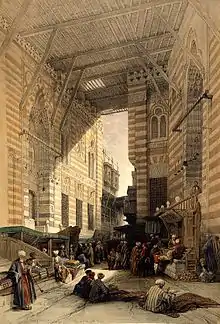
The Mamluks, and the later Ottomans, also built wikalas (caravanserais; also known as khans) to house merchants and goods due to the important role of trade and commerce in Cairo's economy.[4] The most famous and best-preserved example is the Wikala al-Ghuri, which nowadays also hosts regular performances by the Al-Tannoura Egyptian Heritage Dance Troupe.[20] The famous Khan al-Khalili is a famous souq and commercial hub which also integrated caravanserais.[21] Another example of historic commercial architecture is the 17th-century Qasaba of Radwan Bay, now part of the al-Khayamiyya area whose name comes from the decorative textiles (khayamiyya) still being sold here.[1]
Preservation status
Much of this historic area suffers from neglect and decay, in this, one of the poorest and most overcrowded areas of the Egyptian capital.[22] In addition, as reported in the Al-Ahram Weekly, thefts of Islamic monuments and artifacts in the Al-Darb al-Ahmar district threaten their long-term preservation.[23][24][25]
See also
- List of World Heritage Sites in the Arab States
References
- Williams, Caroline (2018). Islamic Monuments in Cairo: The Practical Guide (7th ed.). Cairo: The American University in Cairo Press.
- Planet, Lonely. "Islamic Cairo in Cairo, Egypt". Lonely Planet. Retrieved 2019-11-18.
- UNESCO, Decision Text, World Heritage Centre, retrieved 21 July 2017
- Raymond, André. 1993. Le Caire. Fayard.
- Kennedy, Hugh (2007). The Great Arab Conquests: How the Spread of Islamc Changed the World We Live In. Weidenfeld & Nicolson.
- Swelim, Tarek (2015). Ibn Tulun: His Lost City and Great Mosque. The American University in Cairo Press.
- Brett, Michael (2017). The Fatimid Empire. Edinburgh: Edinbugh University Press.
- Irene Beeson (September–October 1969). "Cairo, a Millennial". Saudi Aramco World. pp. 24, 26–30. Retrieved 2007-08-09.
- "Fāṭimid Dynasty | Islamic dynasty". Encyclopedia Britannica. Retrieved 2019-11-16.
- Lewis, Bernard (1995). The Middle East: A Brief History of the Last 2,000 Years. Scribner.
- Denoix, Sylvie; Depaule, Jean-Charles; Tuchscherer, Michel, eds. (1999). Le Khan al-Khalili et ses environs: Un centre commercial et artisanal au Caire du XIIIe au XXe siècle. Cairo: Institut français d'archéologie orientale.
- Clot, André (1996). L'Égypte des Mamelouks: L'empire des esclaves, 1250-1517. Perrin.
- Abu-Lughod, Janet (1971). Cairo: 1001 Years of the City Victorious. Princeton University Press. p. 37.
- Shillington, Kevin (2005). Encyclopedia of African History. I. Taylor & Francis. p. 342.
- Behrens-Abouseif, Doris. 2007. Cairo of the Mamluks: A History of Architecture and its Culture. Cairo: The American University in Cairo Press.
- Mortada, Hisham (2003). Traditional Islamic principles of built environment. Routledge. p. viii. ISBN 0-7007-1700-5.
- O'Neill, Zora et al. 2012. Lonely Planet: Egypt (11th edition), p. 87.
- El Kadi, Galila; Bonnamy, Alain (2007). Architecture for the Dead: Cairo's Medieval Necropolis. Cairo: The American University in Cairo Press.
- Rabat, Nasser O. (1995). The Citadel of Cairo: A New Interpretation of Royal Mamluk Architecture. E.J. Brill.
- O'Neill, Zora et al. 2012. Lonely Planet: Egypt (11th edition), p. 81.
- Denoix, Sylvie; Depaule, Jean-Charles; Tuchscherer, Michel, eds. (1999). Le Khan al-Khalili et ses environs: Un centre commercial et artisanal au Caire du XIIIe au XXe siècle. Cairo: Institut français d'archéologie orientale.
- Ancient Cairo: Preserving a Historical Heritage, Qantara, 2006.
- Unholy Thefts Archived 2013-06-05 at the Wayback Machine Al-Ahram Weekly, Nevine El-Aref, 26 June - 2 July 2008 Issue No. 903.
- "Al-Darb Al-Ahmar District Mosques". World Monuments Fund.
- Wilton-Steer, Harry Johnstone, photography by Christopher (March 21, 2018). "Alive with artisans: Cairo's al-Darb al-Ahmar district – a photo essay" – via www.theguardian.com.
External links
 Media related to Islamic Cairo at Wikimedia Commons
 Islamic Cairo travel guide from Wikivoyage
Districts and suburbs of Greater Cairo-Giza | ||||||||||
|---|---|---|---|---|---|---|---|---|---|---|
| Cairo Governorate |
|   | ||||||||
| Giza Governorate |
| |||||||||
| Qalyubia Governorate |
| |||||||||