Kafr El Sheikh
Kafr El Sheikh (Egyptian Arabic: كفر الشيخ pronounced [kɑfɾ eʃˈʃeːx]) is an Egyptian city and the capital of Kafr El Sheikh Governorate, Egypt, about 134 km north of Cairo, in the Nile Delta of lower Egypt. As of November 2006, the town had a population of around half- a million.[1]
Kafr El Sheikh
City of hope and future | |
|---|---|
| KFS | |
 Flag Seal  Coat of arms | |
 | |
 Kafr El Sheikh Location in Egypt | |
| Coordinates: 31°06′42″N 30°56′45″E | |
| region | kafr El Sheikh Governorate |
| Governorate | Kafr El Sheikh |
| country | |
| National day | 4th of November |
| Named for | Sheikh Talha Abi Said Tlemceni Al Maghrebi Shazly |
| Elevation | 17 m (56 ft) |
| Population (2017) | |
| • Total | 448,532 |
| • Egypt | 101,245,621 |
| Time zone | UTC+2 (EET) |
| • Summer (DST) | UTC+3 |
| Area code(s) | (+20) 47 |
| Website | Http://www.kafrelsheikh.gov.eg |
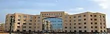
Kafr El Sheikh was earlier known as Duminqun (Arabic: دُمينقون) and was renamed after Sheikh Talha al-Tilmisani who died here in 1234.[2][3] In 2006 the University of Kafr El Sheikh was established.
Kafr El Sheikh is responsible for more than 40% of the total sea food production in Egypt.
Geography
Kafr El Sheikh is located in the southern side of the Kafr El Sheikh Governorate, it is famous for agriculture, especially the production of rice. The city is surrounded to the east by the villages of Qantara and Sawalha which are separated by a small Canal. Kafr Elsheikh has Desouk and Damanhour to its West, Tanta to its South, and the Mediterranean to its North.
KFS Museum
Kafr El-Sheikh Governorate, since the earliest historical times, had a large share of the contribution to the history of Egyptian civilization due to the presence of the city (Bhutto), which is now known as Tell Al-Faraeen, as it was the first capital of the first organized state in Lower Egypt. The museum aims to display the regional history and many artifacts that have been uncovered about it in Kafr El Sheikh Governorate, The museum includes three halls, which include the archaeological holdings that were found in the Great Bhutto Cemetery and the temple area, in which a number of important artifacts were uncovered that embody the story of the conflict between Horus and his uncle Six, in addition to other archaeological sites in Kafr El-Sheikh, including a statue of the deity Horus the Falcon is one of the most amazing statues that have been discovered in Egypt so far, and it is considered a unique copy that can only be matched by the one in the Edfu temple. A hall in the museum was also devoted to displaying the holdings that embody the period of the city of Sakha hosting the journey of the Holy Family during its visit to Egypt, in addition to displaying the history of science during different historical eras such as medicine, veterinary and pharmacy, as well as some topics related to the city of Fuwah, which has a rich Islamic heritage, as it includes all the cultural heritage of Kafr Sheikh as the third heritage city after Cairo and Rasheed.
President El-Sisi inaugurated the Kafr El Sheikh Museum in 2020, which contains many historical and Islamic monuments.
Name story
kafr calls the small circular village. When talha al-talmani came from Morocco, he came to it. He settled in the small village then called denigon in 600h. When he died in 631 a.h. he was buried there. To believe that his "blessing" was founded by the inhabitants of that small village as a "mausoleum", and since then, the village of denegun has been bought at kafr al-talha. In the era of king fouad of Egypt, king fouad set up his palace as a form of recreation, as it was far from cities. His name was al-fouad, and it persisted throughout the reign of his son, king farouk. When the regime was overthrown and the revolution took place. The revolution leadership decided to return kfar sheikh's name to the city, without talaat as a type of abbreviation.
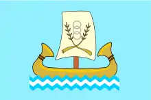
Flag
A pharaonic boat with three overlapping loops, surrounded by two spikes.the boat swims in a blue sea with three winding lines to indicate the coastal environment of the conservation; The three water bodies in the governorate are the Mediterranean Sea, the bars lake and the Nile river. The rings point to the cooperative system, and the sabeans point to the province's reputation for rice production
National Day
Kafr El-Sheikh governorate celebrates its national day on November 4 every year, which coincides with the anniversary of the Burullus naval battle in which the people of Burullus defeated the English destroyer during the tripartite aggression on Egypt. On the morning of November 4, 1956, enemy ships appeared in front of the shore of Burullus, and Egyptian torpedo boats were monitoring their movements, so there was no room for hesitation in clashing with these ships during the day. To the rest of the squadron that emerged from the middle of this curtain to enter a region of hell that comes out from the artillery craters of the enemy fleet, and our boats fired their shells, hitting one of the French battleships and a British destroyer.
The boats returned to revolve around these ships to continue raiding them until their torpedo loads ended, but they were exposed to enemy aircraft raids and the Battle of Burullus ended in a wonderful way of daring and heroism after the Egyptian Navy hit a new example of fighting and engaging torpedo boats during the day and the survival of some of these boats' soldiers was a source of information. The battle of Burullus ended in minutes after it recorded for Egypt a bright page in the history of jihad and honor.

Education
The Governorate of Kafr el Sheikh is the holder of prestigious schools. It also has a university that has the following faculties:
Faculty of Commerce Faculty of Engineering Faculty of Agriculture veterinary school Faculty of Arts
History
Kafr El Sheikh was earlier known as Duminqun (Arabic: دُمينقون) and was renamed after Sheikh Talha al-Tilmisani who died here in 1234. In 2006 the University of Kafr El Sheikh was established.
Kafr El Sheikh is responsible for more than 40% of the total sea food production in Egypt.
Population
The population of the city, according to a census from the Central Agency for Public Mobilization and Statistics, is 3,172,753In the whole government and 448,532 in KFS city in 2006. Kafr El Sheikh city, is the fourth largest city in the Nile Delta.
Census of Egypt arrived 101,245,621 In November 2020.
districts with estimated population in July 2017
Mosques
Talha
ha al-Tlemceni
Abaza
Al malek
Ibn taimia
al israa
Ebad al rahman
Al falaheen
Al fath (Stadium mosque)
Al khayat
Abo al Azaem
Sidi qutb
Al rahman (Mosque of el 47 square)
Sheikha Zahra Coptan
Churches
Justice Church of the Blessed Virgin Mary in Sakha.
Evangelical Church.
Church of St. Demiana and forty virgin.
Saint George's Church.
factories
Kafr El Sheikh is the home to various factories, including a rice mill, a poultry forage factory and a sugar beet factory.[4]
Sport
Kafr El Sheikh owns Kafr El Sheikh SC wich competes in the Egyptian second division league
Climate
Kafr el-Sheikh is classified by Köppen-Geiger climate classification system as hot desert (BWh).
| Climate data for Kafr el-Sheikh, Egypt | |||||||||||||
|---|---|---|---|---|---|---|---|---|---|---|---|---|---|
| Month | Jan | Feb | Mar | Apr | May | Jun | Jul | Aug | Sep | Oct | Nov | Dec | Year |
| Average high °C (°F) | 18.8 (65.8) |
19.8 (67.6) |
22.2 (72.0) |
26 (79) |
30.3 (86.5) |
31.6 (88.9) |
33.5 (92.3) |
33 (91) |
31.5 (88.7) |
29.2 (84.6) |
25 (77) |
20.8 (69.4) |
26.8 (80.2) |
| Daily mean °C (°F) | 12.5 (54.5) |
13.2 (55.8) |
15.4 (59.7) |
18.5 (65.3) |
22.5 (72.5) |
24.6 (76.3) |
26.4 (79.5) |
26 (79) |
24.7 (76.5) |
22.6 (72.7) |
19 (66) |
14.7 (58.5) |
20.0 (68.0) |
| Average low °C (°F) | 6.3 (43.3) |
6.6 (43.9) |
8.6 (47.5) |
11.1 (52.0) |
14.7 (58.5) |
17.7 (63.9) |
19.4 (66.9) |
19 (66) |
18 (64) |
16 (61) |
13.1 (55.6) |
8.6 (47.5) |
13.3 (55.8) |
| Average precipitation mm (inches) | 19 (0.7) |
13 (0.5) |
6 (0.2) |
4 (0.2) |
3 (0.1) |
0 (0) |
0 (0) |
0 (0) |
0 (0) |
4 (0.2) |
9 (0.4) |
14 (0.6) |
72 (2.9) |
| Source: Climate-Data.org[5] | |||||||||||||
Notable people
- Hamdeen Sabahi, Egyptian Politician, the leader of the Dignity Party and one of the leaders of the Egyptian opposition before the 2011 Egyptian revolution
- Trezeguet, Egyptian footballer
- Osama Anwar Okasha, Egyptian screenwriter and journalist
- Saad Zaghloul, Egyptian Nationalist and politician
See also
References
- Central Agency for Public Mobilization and Statistics, Egypten. Accessed 11 November 2006.
- الأسعد بن مماتي. قوانين الدواوين.
- Carsten Peust (2010). Die Toponyme vorarabischen Ursprungs im modernen Ägypten. p. 56.
- Kafr Elsheikh Governrate "Archived copy". Archived from the original on 2007-10-23. Retrieved 2007-12-03.CS1 maint: archived copy as title (link) sic
- "Climate: Kafr Al-Sheikh - Climate graph, Temperature graph, Climate table". Climate-Data.org. Retrieved 13 August 2013.
| 1,000,000 and more | |
|---|---|
| 300,000–999,999 | |
| 100,000–299,999 | |
| <99,999 | |