Kalimpong district
Kalimpong district is a district in the state of West Bengal, India. It was formed on 14 February 2017, after splitting from the Darjeeling district as the 21st district of West Bengal.[2][3] It consists of the Kalimpong Municipality and three community development blocks: Kalimpong I, Kalimpong II and Gorubathan. The district has its headquarters at Kalimpong.
Kalimpong district | |
|---|---|
District of West Bengal | |
 | |
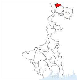 Location of Kalimpong district in West Bengal | |
| Country | |
| State | |
| Division | Jalpaiguri |
| Headquarters | Kalimpong |
| Government | |
| • Lok Sabha constituencies | Darjeeling |
| • Vidhan Sabha constituencies | Kalimpong |
| Area | |
| • Total | 1,053.60 km2 (406.80 sq mi) |
| Population (2011) | |
| • Total | 251,642[1] |
| Time zone | UTC+05:30 (IST) |
| Website | kalimpongdistrict |
Area
Apart from the Kalimpong municipality that consists of 23 wards, the district contains rural areas of 42 gram panchayats under three community development blocks: Kalimpong I, Kalimpong II and Gorubathan.[4]
Kalimpong subdivision has an area of 1,053.60 km2 (406.80 sq mi), with Kalimpong I block having an area of 360.46 km2 (139.17 sq mi); Kalimpong II block an area of 241.26 km2 (93.15 sq mi); Gorubathan block an area of 442.72 km2 (170.94 sq mi); and Kalimpong Municipality an area of 9.16 km2 (3.54 sq mi).[1]
Blocks
Kalimpong I block
Kalimpong I block consists of rural areas with 18 gram panchayats, namely Bong, Kalimpong, Samalbong, Tista, Dr. Grahams Homes, Lower Echhay, Samthar, Neembong, Dungra, Upper Echhay, Seokbir, Bhalukhop, Yangmakum, Pabringtar, Sindebong, Kafer Kanke Bong, Pudung and Tashiding.[4] This block has one police station at Kalimpong.[5] Headquarters of this block is in Kalimpong.[6]
Kalimpong II block
Kalimpong II block consists of rural areas only with 13 gram panchayats, namely Dalapchand, Kashyong, Lolay, Lingseykha, Gitdabling, Lava-Gitbeong, Payong, Kagay, Lingse, Shangse, Pedong, Syakiyong and Shantook.[4] This block is served by Kalimpong police station.[5] Headquarters of this block is in Algarah.[6]
Gorubathan block
Gorubathan block consists of rural areas only with 11 gram panchayats, namely Dalim, Gorubathan–I, Gorubathan–II, Patengodak, Todey Tangta, Kumai, Pokhreybong, Samsing, Aahaley, Nim and Rongo.[4] This block has two police stations: Gorubathan and Jaldhaka.[5] Headquarters of this block is in Fagu.[6]
Legislative segments
As per order of the Delimitation Commission in respect of the delimitation of constituencies in West Bengal, the whole area under the district of Kalimpong (formerly Kalimpong subdivision), namely the Kalimpong municipality and the three blocks of Kalimpong–I, Kalimpong–II and Gorubathan together will constitute the Kalimpong assembly constituency of West Bengal. This constituency will be part of Darjeeling Lok Sabha constituency.[7]
Demographics
According to the 2011 census, Kalimpong district (enumerated as Kalimpong subdivision then) has a population of 251,642. Kalimpong I block had a population of 74,746; Kalimpong II block had a population of 66,830; Gorubathan block had a population of 60,663; and Kalimpong Municipality had a population of 49,403.[1]
The majority of the population today in Kalimpong district are the Gorkhas. According to the 2011 census, 73.4% of the population speaks Nepali, 2.63% Hindi and 2.42% Lepcha as their first language.
Flora and fauna
Kalimpong district is home to the Neora Valley National Park, which has an area of 159.89 km2 (61.73 sq mi).[8]
References
- "District Census Handbook-Darjiling" (PDF). Directorate of Census Operations, West Bengal. Retrieved 30 March 2017.
- "Carved out of Darjeeling, Kalimpong a district today". Times of India. Retrieved 14 February 2017.
- "Kalimpong district may stoke Gorkhaland fire". 13 February 2017.
- "Directory of District, Sub division, Panchayat Samiti/ Block and Gram Panchayats in West Bengal, March 2008". West Bengal. National Informatics Centre, India. 19 March 2008. Archived from the original on 25 February 2009. Retrieved 9 December 2008.
- "District Profile". Official website of Darjeeling district. Retrieved 9 December 2008.
- "Contact details of Block Development Officers". Darjeeling district. Panchayats and Rural Development Department, Government of West Bengal. Retrieved 26 December 2008.
- "Press Note, Delimitation Commission" (PDF). Assembly Constituencies in West Bengal. Delimitation Commission. pp. 5, 23. Retrieved 10 January 2009.
- "National Parks". ENVIS Centre on Wildlife & Protected Areas. Retrieved 17 February 2017.
External links
| Wikimedia Commons has media related to Kalimpong district. |
Places adjacent to Kalimpong district | |
|---|---|
Cities, towns and locations in Kalimpong District | |
|---|---|
| Cities, municipal and census towns | |
| Locations other than cities and towns |
|
| See also |
|
Kalimpong district topics | |||
|---|---|---|---|
| General | |||
| People | |||
| Community development blocks |
| ||
| Higher Education | |||
| Rivers | |||
| Transport | |||
| Lok Sabha constituencies | |||
| Vidhan Sabha constituencies | |||
| See also |
| ||
