Khun Han District
Khun Han (Thai: ขุนหาญ, pronounced [kʰǔn hǎːn]) is a district (amphoe) in the southern part of Sisaket Province, northeastern Thailand.
Khun Han
ขุนหาญ | |
|---|---|
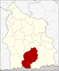 District location in Sisaket Province | |
| Coordinates: 14°37′2″N 104°25′28″E | |
| Country | Thailand |
| Province | Sisaket |
| Area | |
| • Total | 723.1 km2 (279.2 sq mi) |
| Population (2008) | |
| • Total | 104,015 |
| • Density | 143.8/km2 (372/sq mi) |
| Time zone | UTC+7 (ICT) |
| Postal code | 33150 |
| Geocode | 3308 |
History
In 1958 the minor district Khun Han (then still spelled ขุนหาร) was upgraded to a full district.[1]
Geography
The district is bounded in the south by the Dangrek Range. Neighboring districts are (from the west clockwise): Phu Sing, Khukhan, Phrai Bueng, Si Rattana, and Kantharalak of Sisaket Province, and Oddar Meancheay of Cambodia.
Administration
The district is divided into 12 sub-districts (tambons), which are further subdivided into 145 villages (mubans). Khun Han itself is a sub-district municipality (thesaban tambon) and covers parts of tambons Si and Non Sung. Other sub-district municipalities are Si, Krawan, Non Sung, Kanthrom, and Pho Krasang, each covering the same-named sub-district except those areas belonging to Khun Han municipality. The remaining seven sub-districts each have a tambon administrative organization (TAO).
| No. | Name | Thai | Villages | Pop. |
|---|---|---|---|---|
| 1. | Si | สิ | 14 | 11,461 |
| 2. | Bak Dong | บักดอง | 22 | 14,666 |
| 3. | Phran | พราน | 20 | 15,716 |
| 4. | Pho Wong | โพธิ์วงศ์ | 8 | 6,192 |
| 5. | Phrai | ไพร | 11 | 6,406 |
| 6. | Krawan | กระหวัน | 12 | 8,701 |
| 7. | Khun Han | ขุนหาญ | 9 | 5,813 |
| 8. | Non Sung | โนนสูง | 9 | 7,791 |
| 9. | Kanthrom | กันทรอม | 13 | 8,471 |
| 10. | Phu Fai | ภูฝ้าย | 8 | 5,009 |
| 11. | Pho Krasang | โพธิ์กระสังข์ | 14 | 8,990 |
| 12. | Huai Chan | ห้วยจันทร์ | 5 | 4,799 |
References
- พระราชกฤษฎีกาจัดตั้งอำเภอกระสัง อำเภอกระนวน อำเภอบางกอกใหญ่ อำเภอขุนหาร อำเภอพนา อำเภอปากช่อง อำเภอวังเหนือ อำเภอวังชิ้น อำเภอแม่ทา อำเภอหนองหมู อำเภอสระแก้ว อำเภออมก๋อย อำเภอบางซ้าย อำเภอทับสะแก อำเภอบุณฑริก อำเภอลานสะกา อำเภอจอมบึง อำเภอท่ายาง อำเภอสามเงา อำเภอฟากท่า อำเภอบ้านเขว้า อำเภอชานุมาน อำเภอแม่พริก อำเภอท่าสองยาง อำเภอสะเมิง อำเภอหนองแขม อำเภอพระแสง พ.ศ. ๒๕๐๑ (PDF). Royal Gazette (in Thai). 75 (55 ก): 321–327. 1958-07-22.
External links
- amphoe.com (Thai)
Sisaket (capital) | ||
| Districts (amphoe) |  | |
| Related topics | ||
| Neighboring areas |
| |
