Kapuas River
The Kapuas River (or Kapoeas River) is a river in the Indonesian part of Borneo island, at the geographic center of Maritime Southeast Asia. At 1,143 kilometers (710 mi) in length, it is the longest river of Indonesia[1][2] and one of the world's longest island rivers.[3] It originates in the Müller mountain range at the center of the island and flows west into the South China Sea creating an extended marshy delta. The delta is located west-southwest of Pontianak, the capital of the West Kalimantan province.[4] This Kapuas River should be distinguished from another Kapuas River, which starts on the other side of the same mountain range in central Borneo, but flows to the south, merging with the Barito River and discharging into the Java Sea.
| Kapuas | |
|---|---|
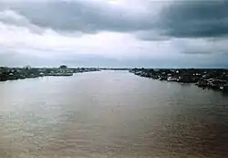 The Kapuas River as it flows through Pontianak | |
| Location | |
| Country | Indonesia |
| Physical characteristics | |
| Source | |
| • location | Mount Raya at Müller Mountain Range |
| • elevation | 2,278 m (7,474 ft) |
| Mouth | |
• location | South China Sea |
• elevation | 0 m (0 ft) |
| Length | 1,143 km (710 mi) |
| Basin size | 98,749 km2 (38,127 sq mi) |
| Discharge | |
| • average | 6,000 m3/s (210,000 cu ft/s) |
| • maximum | 7,530 m3/s (266,000 cu ft/s) |
Geography and hydrology
The river is 1,143 km (710 mi) long and up to 700 m (2,300 ft) wide at its delta;[3] with a total area of 98,740 km2 (38,120 sq mi), the river basin covers more than 67% of West Kalimantan.[2][5] The discharge rate varies through the year, averaging around 6,000–7,000 m3/s (210,000–250,000 cu ft/s) at the delta and 2,000 m3/s (71,000 cu ft/s) upstream, at the confluence of the Tawang River. The discharge peaks during the rainy seasons in April and November, during which the water level may rise by 10–12 m (33–39 ft) overnight, overflowing river banks and flooding the nearby areas.[2][6][7]
The river originates near the center of Borneo, south from the Indonesian-Malaysian border, in the joint between the western slope of the Müller Mountain Range, which runs through the island center, and the southern slope of the Upper Kapuas Range (Indonesian: Kapuas Hulu), which is located more to the west. For about 165 km (103 mi) it flows through a mountainous terrain and then descends to a marshy plain.[6] There, the elevation decreases by only 50 meters (160 ft) over 900 km (560 mi) from Putussibau to the river delta.[8] About 350 km (220 mi) from the source, near the northern shore of the river, lies a system of Kapuas Lakes which are connected to the river by numerous channels. These lakes are Bekuan (area 1,268 hectares), Belida (600 ha), Genali (2,000 ha), Keleka Tangai (756 ha), Luar (5,208 ha), Pengembung (1,548 ha), Sambor (673 ha), Sekawi (672 ha), Sentarum (2,324 ha), Sependan (604 ha), Seriang (1,412) Sumbai (800 ha), Sumpa (664) and Tekenang (1,564 ha).[9] When the monthly precipitation exceeds about 300 mm (12 in), the river overflows its banks, diverting much of its waters to the lakes at a rate of up to 1,000 m3/s (35,000 cu ft/s), and forming a single volume of water with them. This outflow prevents massive flooding of the lower reaches of the river; it also promotes fish migration from the river to the lakes for spawning, but drives birds away from the lakes.[7]
The river discharges into the South China Sea creating a marshy delta, which spreads both inland and into the sea, with the silt deposits extending up to 50–60 km (31–37 mi) from the Borneo coast.[8] The delta is located west-southwest of Pontianak, the capital of West Kalimantan province, which lies at the equator.[10] The delta has five arms, of which the northernmost one is the widest, and is therefore called the Big Kapuas (Indonesian: Kapuas Besar). The largest tributary is the Melawi River, which occurs to the left near the city of Sintang, about 465 km from the mouth. Other major tributaries are the Landak, Kubu, Punggur and Sekayam rivers.[10]
Climate
The climate is warm and very humid, with the average annual precipitation ranging from year to year between 2,863 to 5,517 mm (112.7–217.2 in), and the number of rainy days between 120 and 309; the largest precipitation was observed in 1976 (120 rainy days) and the wettest in 1988, with only 184 rainy days.[5] The temperature is rather stable with a typical minimum of 24 °C (75 °F) and maximum of 32 °C (90 °F) through the whole year.[11]
Flora and fauna
In the upper and middle reaches, the river flows through dense tropical forests; the rich flora and fauna are the subject of international research.[5] Discoveries of new species are frequent, such as of the Kapuas mud snake (Enhydris gyii), which was discovered in 2003–2005 by German and American herpetologists. This species is remarkable in that it can spontaneously change its skin color, similar to the chameleon.[12][13]
Otters and crocodiles are common in the Kapuas River, but frogs are nearly absent.[14] Agile gibbons (Hylobates agilis), Müller's Bornean gibbons (Hylobates muelleri), Prevost's squirrels (Callosciurus prevostii) and treeshrews inhabit the trees above the river.[15]
There are two national parks on the river banks, Betung Kerihun with an area of 8,000 km2 and Danau Sentarum (area 1,320 km2), the latter includes the Kapuas Lakes.[5][16]
Fish
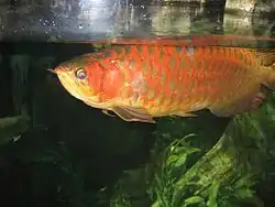
About 300 species of fish have been identified in the river basin, of which 234 are of high economical value.[1] This is more fish species than any other river basin in Indonesia.[17] They belong to 120 genera and 40 families with the two major groups being cyprinids and catfish. More than 30% of the species originate from the sea and inhabit the delta areas.[18] Among the economically important species are food fish such as Pangasius catfish, giant gourami, kissing gourami, snakeheads and large barbs (Leptobarbus, Puntioplites, Tor and others), and species from the aquarium trade such as the super red arowana and rasboras.[17] Because of overfishing and habitat degradation, several species are threatened. Among these are the endangered arowana and white-edge freshwater whipray, and the wallago catfish, which formerly migrated in large groups in the Kapuas River.[17]
Part of the high species diversity in the Kapuas is related to the many different habitats in the river basin. In the headwaters are fast-flowing highland streams, typically dominated by small loaches, and small —often acidic (blackwater)— forest streams and peat swamps with species such as the tiny Sundadanio rasboras and macropodusine gouramis.[17] The main river itself also includes several habitats, ranging from the nearshore to open waters. In the deepest sections, no light exists and in one species, Lepidocephalus spectrum, this has resulted in a complete reduction of both eyes and pigmentation (similar to cavefish).[19]

Owing to the warm climate and abundance of food, most fishes breed all through the year with only a few species like fire eel (Mastacembelus erythrotaenia) having certain reproduction periods. The number of individuals per species is relatively low. The large variety of species may be explained by the fact that some 6,000 years ago, the Kapuas River, as a tributary of the Sunda River, was connected to other tributary rivers of South Sumatra, Java and Malay Peninsula. Apart from fish, there are numerous crabs, prawns, water striders and other aquatic insects.[20] The rich flora and fauna results in very complex food chains, with fishes consuming foods ranging from fruits to other fish. For example, Hemirhamphodon pogonognathus feeds exclusively on terrestrial insects. Abundant fruits and seeds enter the river after falling from large trees which bend over its waters.[21] The feeding habits of the fish in the Kapuas River are distributed as follows: 54% are omnivores; 36% are carnivorous and eat other fish (14%), insects (5%) and mixed small forest animals (17%). The remaining 10% are herbivorous, with 4% of them specialising in algae.[14]
Transport and economic value
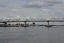
The Kapuas River is the major waterway connecting the center of the island with its western coast. The large river width and depth (up to 27 meters[3]) support intensive cargo and passenger shipping over most of the river length. Ships with a draft of up to 3 meters can navigate up to Sintang, 465 km from the mouth, and those with a draft up to 2 meters can reach the town of Putussibau (902 km from the mouth). Logging and rafting of timber occur all along the river. Fishing is also common, especially at the Kapuas Lakes and near the river delta.[6][22] The Tayan Bridge, opened in 2016, crosses over the river and is the longest bridge in Kalimantan.[23]
See also
References
- Friedhelm Göltenboth (2006) Ecology of insular Southeast Asia: the Indonesian Archipelago, Elsevier, ISBN 0-444-52739-7 p. 157
- MacKinnon, p. 133
- Noni Arnee (21 August 2009). "Pesona di Bawah Garis Katulistiwa" (in Indonesian). Suara Merdeka. Archived from the original on 8 March 2012. Retrieved 22 March 2010.
- Kapuas River, Encyclopædia Britannica on-line
- "Betung Kerihun National Park (Transborder Rainforest Heritage of Borneo)". UNESCO World Heritage Centre. 2 February 2004.
- Great Soviet Encyclopedia. 11. Moscow. 1969–1978. p. 367. reduced electronic version
- MacKinnon, p. 160
- MacKinnon, p. 131
- MacKinnon, pp. 152, 159
- South Kalimantan
- Pontianak, Borneo Climate. ClimaTemps.com
- John C. Murphy; Harold K. Voris; Mark Auliya (2005). "A new species of Enhydris (Serpentes: Colubridae: Homalopsinae) from the Kapuas river system, West Kalimantan, Indonesia" (PDF). The Raffles Bulletin of Zoology. 53 (2): 271–275.
- "Snake displays changing colours". BBC News. 26 June 2006. Retrieved 9 January 2007.
- MacKinnon, p. 162
- MacKinnon, pp. 52–53
- Elizabeth Linda Yuliani; Yayan Indriatmoko; Seselia Ernawati; Leon Budi Prasetyo; Zul MS (October 2007). "Promoting Good Governance in Danau Sentarum National Park under Decentralization" (PDF). Archived from the original (PDF) on 8 October 2012. Retrieved 4 November 2010.
- Roberts, T.R. (1989). "The freshwater fishes of Western Borneo (Kalimantan Barat, Indonesia)". Memoirs of the California Academy of Sciences. 14: 1–210.
- MacKinnon, p. 143
- Deein; Tangjitjaroen; and Page (2014). "A revision of the spirit loaches, genus Lepidocephalus (Cypriniformes, Cobitidae)". Zootaxa. 3779 (3): 341–352.CS1 maint: uses authors parameter (link)
- MacKinnon, p. 132
- MacKinnon, p. 161
- MacKinnon, p. 457
- "Jembatan Terpanjang di Kalimantan Ini Tahan 100 Tahun". Tempo (in Indonesian). 23 March 2016. Archived from the original on 14 April 2016. Retrieved 4 July 2017.
Bibliography
- MacKinnon, Kathy The ecology of Kalimantan, Oxford University Press, 1996, ISBN 0-945971-73-7