Karabakh
Karabakh (Azerbaijani: Qarabağ [ɡɑɾɑbɑɣ]; Armenian: Ղարաբաղ, romanized: Gharabagh [ʁɑɾɑbɑʁ]) is a geographic region in present-day eastern Armenia and southwestern Azerbaijan, extending from the highlands of the Lesser Caucasus down to the lowlands between the rivers Kura and Aras.
Karabakh | |
|---|---|
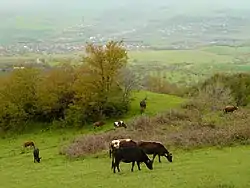 A landscape in Nagorno-Karabakh - a view of the municipality of Qırmızı Bazar | |
| Etymology: "Black garden" | |
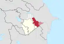
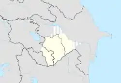 Map of Karabakh within modern borders.
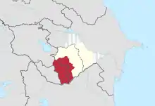
Typical definition of Karabakh.
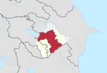
Maximum historical definition of Karabakh. | |
| Country | Armenia and Azerbaijan |
It is conventionally divided into three regions: Highland Karabakh (covered mostly by present-day Nagorno-Karabakh), Lowland Karabakh (the steppes between the Kura and Aras rivers), and the eastern slopes of the Zangezur Mountains (roughly Syunik and Kalbajar-Lachin).[1][2][3][4][5]
Etymology
The Russian name Карабах, transliterated Karabakh, derives from the Azerbaijani Qarabağ, which is generally believed to be a compound of the Turkic word kara (black) and the Iranian word bagh (garden), literally meaning "black garden."[6] However, there are some other hypotheses.
Russian Orientalist Vladimir Minorsky believed that the name possibly connected to the same-titled extinct Turkic tribe. By comparison, there are similar toponyms in Azerbaijan, Iran, Turkey and Afghanistan.[7]
According to Iranian linguist Abdolali Karang, kara could have derived from kaleh or kala, which means "large" in the Harzani dialect of the extinct Iranian Old Azeri language.[8][9][10] The Iranian-Azerbaijani historian Ahmad Kasravi also speaks of the translation of kara as "large" and not "black."[11] The kara prefix has also been used for other nearby regions and landmarks, such as Karadagh (dagh "mountain") referring to a mountain range, and Karakilise (kilise "church") referring to the largest church complex in its area, built mainly with white stone, the Monastery of Saint Thaddeus. In the sense of "large," Karakilise would translate to "large church," and Karabakh would translate to "large garden."
Another theory, proposed by Armenian historian Bagrat Ulubabyan, is that, along with the "large" translation of kara,[12] the bagh component was derived from the nearby canton called Baghk, which at some point was part of Melikdoms of Karabakh within modern-day Karabakh — Dizak and the Kingdom of Syunik (in Baghk, the -k suffix is a plural nominative case marker also used to form names of countries in Classical Armenian). In this sense, Karabakh would translate to "Greater Baghk."[13]
The placename is first mentioned in the thirteenth and fourteenth centuries in The Georgian Chronicles (Georgian: ქართლის ცხოვრება "Life of Kartli"), and in Persian sources.[14] The name became common after the 1230s when the region was conquered by the Mongols.[15] The first time the name was mentioned in medieval Armenian sources was in the fifteenth century, in Thomas of Metsoph's History of Tamerlane and His Successors.[14]
Geography
Karabakh is a landlocked region located in the south of Armenia and the west of Azerbaijan. There is currently no official designation for what constitutes the whole of Karabakh. Historically, the maximum extent of what could be considered Karabakh was during the existence of the Karabakh Khanate in the 18th century, which extended from the Zangezur Mountains in the west, following eastwards along the Aras river to the point where it meets with the Kura river in the Kur-Araz Lowland. Following the Kura river north, it stretched as far as what is today the Mingachevir reservoir before turning back to the Zangezur Mountains through the Murov Mountains. However, when not referring to the territory covered by the Karabakh Khanate, the northern regions are often excluded (modern-day Goranboy and Yevlakh). During the Russian Empire, the eastern lowlands where the Kura and Aras rivers meet (mostly modern-day Imishli) were also excluded, but most pre-Elisabethpol maps include that region in Karabakh.
| Zangezur | Highlands or mountainous region | Lowlands or steppe |
|---|---|---|
 |
 |
 |
|
History
Antiquity
The region today referred to as Karabakh, which was populated with various Caucasian tribes, is believed to have been conquered by the Kingdom of Armenia in the 2nd century BC and organized as parts of the Artsakh, Utik and the southern regions of Syunik provinces. However, it is possible that the region had earlier been part of the Satrapy of Armenia under the Orontid dynasty from as early as the 4th century BC.[16] After the partition of Armenia by Rome and Persia in 387 AD, Artsakh and Utik became a part of the Caucasian Albanian satrapy of Sassanian Persia, while Syunik remained in Armenia.
Middle Ages
The Arab invasions later led to the rise of several Armenian princes who came to establish their dominance in the region.[17] Centuries of constant warfare on the Armenian Plateau forced many Armenians, including those in the Karabakh region, to emigrate and settle elsewhere. During the period of Mongol domination, a great number of Armenians left Lowland Karabakh and sought refuge in the mountainous (Highland) heights of the region.[18]
From the 11th century and onwards Karabakh became a home to numerous Oghuz Turkic tribes, the ancestors of the modern Azeris, who sticked to the nomadic way of life, circulating between the winter pastures in Karabakh lowlands and the summer pastures in Karabakh highlands.[19][20] These tribes dominated the region,[19] and were key allies of the Safavid Empire, that owned Karabakh in 16th-early 18th centuries.[21]
In the fifteenth century, the German traveler Johann Schiltberger toured Lowland Karabakh and described it as a large and beautiful plain in Armenia, ruled by Muslims.[22] Highland Karabakh from 821 until the early 19th century passed under the hands of a number of states, including the Abbasid Caliphate, Bagratid Armenia, the Mongol Ilkhanate and Jalayirid Sultanates, the Turkic Kara Koyunlu, Ak Koyunlu and Karabakh Baylarbaylik states of the Safavid Empire.[23] Armenian princes times ruled as vassal territories by the Armenian House of Khachen and its several lines, the latter Melikdoms of Karabakh.[17] The Safavids appointed the rulers of Ganja khanate from Ziad-oglu Qajar family to govern Karabakh.[24] It was also invaded and ruled by Ottoman Empire between 1578-1605 and again between 1723-1736, as they briefly conquered it during the Ottoman-Safavid War of 1578-1590 and during the disintegration of Safavid Iran, respectively. In 1747, Panah Ali Khan, a local Turkic chieftain from the Javanshir clan, seized control of the region after the death of the Persian ruler Nader Shah, and both Lower Karabakh and Highland Karabakh comprised the new Karabakh Khanate.[17] The Iranian Qajar dynasty reestablished rule over the region several years later.
Early Modern Age
In 1813, under the terms of the Treaty of Gulistan, the region of Karabakh was lost by the Persians to the Russian Empire. Under Russian rule, Karabakh (both Lowland and Highland) was a region with an area of 13,600 km2 (5,250 sq mi), with Shusha (Shushi) as its most prominent city. Its population consisted of Armenians and Muslims (mainly of Azerbaijanis, then known as Tatars, but also Kurds). The Russians conducted a census in 1823 and had tallied the number of villages (though not the number of people) and assessed the tax basis of the entire Karabakh khanate, which also included Lowland Karabakh.[25] It is probable that the Armenians formed the majority of the population of Eastern Armenia at the turn of the seventeenth century,[26] but following Shah Abbas I's massive relocation of Armenians in 1604-05 their numbers decreased markedly, as they eventually became a minority among their Muslim neighbors.
According to the statistics of the initial survey carried out by the Russians in 1823 and an official one published in 1836, Highland Karabakh was found almost overwhelmingly Armenian in population (96.7%).[27] In contrast, the population of the Karabakh khanate, taken as a whole, was largely made up of Muslims (91% Muslim versus 9% Armenian).[28] A decade after the Russian annexation of the region, many Armenians who had fled Karabakh during the reign of Ibrahim Khalil Khan (1730-1806) and settled in Yerevan, Ganja, and parts of Georgia were repatriated to their villages, many of which had been left derelict.[27] An additional 279 Armenian families were settled in the villages of Ghapan and Meghri in Syunik.[27] Though some of the returning Armenians wished to settle in Karabakh, they were told by Russian authorities that there was no room for them.[27] This took place at the same time as many of the region's Muslims departed for the Ottoman Empire and Qajar Iran.[29] The population of Karabakh, according to the official returns of 1832, consisted of 13,965 Muslim and 1,491 Armenian families, besides some Nestorian Christians and Gypsies. The limited population was ascribed to the frequent wars and emigration of many Muslim families to Iran since the region's subjection to Russia, although many Armenians were induced by the Russian government, after the Treaty of Turkmenchay, to emigrate from Persia to Karabakh.[30]
It has to be noted that censuses and surveys, which were conducted in winter, did not count tens of thousands Azeri nomads, who stayed in the lowlands during winter and were migrating en masse to the summer pastures in Mountainous Karabakh during the warmer months. Seasonal demographic changes were significant, as e.g. in 1845 in historic Karabakh the population included 30,000 Armenians and 62,000 Moslems (Azeris), of whom approximately 50,000 were nomads, who circulated between Lowland and Mountainous Karabakh.[31]
In 1828 the Karabakh khanate was dissolved and in 1840 it was absorbed into the Kaspijskaya oblast, and subsequently, in 1846, made a part of Shemakha Governorate. In 1876 it was made a part of the Elisabethpol Governorate, an administrative arrangement which remained in place until the Russian Empire collapsed in 1917.
Soviet rule
After the dissolution of Russian Empire Karabakh, Zangezur and Nakhchivan were disputed between newly established republics of Armenia and Azerbaijan.[32] Fighting between two republics broke out. Following the defeat of the Ottoman Empire in World War I, British troops occupied the South Caucasus. The British command affirmed Khosrov bey Sultanov (an appointee of the Azerbaijani government) as the provisional governor-general of Karabakh and Zangezur, pending a final decision by the Paris Peace Conference. Local Armenian Council confronted this till the August of 1919, when it was subjected by Azeri military to admit the provisional jurisdiction of Azerbaijan. However, later Karabakh Armenians accused Azerbaijan in the violation of the treaty of 1919 and pursuit for the further submission of them to Azerbaijan and rebelled in the March of 1920 with the help of emissaries from Armenia. Uprising failed, as Azerbaijani forced quickly restored control over the main centers of Karabakh (Shusha, Khankendi, Askeran), although fighting in the countryside of Mountainous Karabakh continued. In April 1920, Azerbaijan and Armenia were sovietized and Karabakh's status was taken up by the Soviet authorities. In 1921 after the heavy trilateral negotiations Soviets decided that Karabakh has to remain within Azerbaijan.[33]
In 1923, Armenian parts of Mountainous Karabakh were made a part of the newly established Nagorno-Karabakh Autonomous Oblast (NKAO), an administrative entity of the Azerbaijan SSR. According to the first census of this administrative unit the population was 94% Armenian,[34] however, this census did not count a considerable Azeri nomadic population.[35] Besides, it has to be mentioned that NKAO is Armenian-dominated part of historical Mountainous Karabakh[36] and many Azeri villages of this region were administratively excluded from the former.[37]
During the Soviet period, several few attempts were made by the authorities of the Armenian SSR to unite it with the NKAO but these proposals found no support in Moscow.
Nagorno-Karabakh War
In February 1988, within the context of Mikhail Gorbachev's glasnost and perestroika policies, the Supreme Soviet of the NKAO voted to unite itself with Armenia.[38] By the summer of 1989 the Armenian-populated areas of the NKAO were under blockade by Azerbaijan as a response to Armenia's blockade against Nakhchivan, cutting road and rail links to the outside world. On July 12 the Nagorno-Karabakh AO Supreme Soviet voted to secede from Azerbaijan, which was rejected unanimously by the Supreme Soviet of USSR, declaring NKAO had no right to secede from Azerbaijan SSR under Soviet Constitution.[39] Soviet authorities in Moscow then placed the region under its direct rule, installing a special commission to govern the region. In November 1989 the Kremlin returned the oblast to Azerbaijani control. The local government in the region of Shahumian also declared its independence from the Azerbaijan SSR in 1991.[40]
In late 1991, the Armenian representatives in the local government of the NKAO proclaimed the region a republic, independent from Azerbaijan. Most of upper Karabakh and portions of lowland Karabakh came under the control of Armenian forces following the First Nagorno-Karabakh war. The region's Azerbaijani inhabitants were expelled from the territories that came under Armenian control.
While Nagorno-Karabakh remained an internationally recognised territory of Azerbaijan, the four UN Security Council resolutions, adopted in 1993 and demanding immediate withdrawal of the Armenian occupying forces from all occupied regions of Azerbaijan, remained unfulfilled until 2020.[41] In 2020, a new war erupted in the region, which saw Azerbaijan retake control of most of southern Karabakh (Fuzuli District, Jabrayil District, Zangilan District, Qubadli District, Hadrut District). A trilateral ceasefire agreement signed on 10 November 2020, ended the war and forced Armenia to return control of all of the remaining territories surrounding Nagorno-Karabakh.
Karabakh dialect
The Armenian population of the region speaks the Karabakh dialect of Armenian which has been heavily influenced by the Persian, Russian, and Turkish languages.[42] It was the most extensively spoken of all Armenian dialects until the Soviet period when the dialect of Yerevan became the official tongue of the Armenian SSR.[5]
Flora
The Khari-bulbul (Ophrys caucasica) is a flowering plant that is considered by some to be "official flower" of the Karabakh region.[43] Its flower shape has been interpreted as being similar to a bulbul.
Populations of Tulipa armena found in the Karabakh mountain range have been called T. karabachens.[44][45]
See also
Notes
- (in Armenian) Leo. Երկերի Ժողովածու [Collected Works]. Yerevan: Hayastan Publishing, 1973, vol. 3, p. 9.
- (in Armenian) Ulubabyan, Bagrat Արցախյան Գոյապայքարը [The Struggle for the Survival of Artsakh]. Yerevan: Gir Grots Publishing, 1994, p. 3. ISBN 5-8079-0869-4.
- Mirza Jamal Javanshir Karabagi. The History of Karabakh. Chapter 2: About the borders, old cities, population aggregates and rivers of the Karabakh region.
- Mirza Jamal Javanshir Karabagi. A History of Qarabagh: An Annotated Translation of Mirza Jamal Javanshir Qarabaghi's Tarikh-e Qarabagh, trans. George A. Bournoutian. Costa Mesa, CA: Mazda Publishing, 1994, pp. 46ff.
- Hewsen, Robert H. "The Meliks of Eastern Armenia: A Preliminary Study," Revue des Études Arméniennes 9 (1972), p. 289, note 17.
- Regions and territories: Nagorno-Karabakh. BBC News. Retrieved August 29, 2009.
- Minorsky, Vladimir (1943). Tadhkirt Al-muluk. p. 174.
- Karang, Abdolali. Tati va Harzani: Do lahje az zabane bastani-ye Azerbaijan (in Farsi), Tabriz: E. Vaezpour, 1954
- Dalby, Andrew (1998). Dictionary of Languages: The Definitive Reference to More Than 400 Languages. Columbia University Press. p. 156. ISBN 978-0-231-11568-1., p. 496.
- "Azari, the Old Iranian Language of Azerbaijan", Encyclopædia Iranica, op. cit., Vol. III/2, 1987 by Ehsan Yarshater. External link:
- Kasravi, Ahmad. Collection of 78 papers and talks (in Farsi), ed. Yahya Zeka, Lectures, Tehran: Sherkate Sahami Ketabhaye Jibi, 2536, pp. 365/431
- History of the Principality of Khachen, Yerevan, 1975, p. 2
- Hewsen, Robert H. Armenia: a Historical Atlas. Chicago: University of Chicago Press, 2001, pp. 119–120.
- (in Armenian) Ulubabyan, Bagrat. «Ղարաբաղ» [Gharabagh]. Armenian Soviet Encyclopedia. Yerevan: Armenian Academy of Sciences, 1981, vol. 7, p. 26.
- Great Soviet Encyclopedia, "NKAO, Historical Survey", 3rd edition, translated into English, New York: Macmillan Inc., 1973.
- Hewsen. Armenia, pp. 118-121.
- Hewsen. Armenia, pp. 119, 155, 163, 264-265.
- Bournoutian, George A. "Review of The Azerbaijani Turks: Power and Identity Under Russian Rule, by Audrey L. Altstadt," Armenian Review 45/2 (Autumn 1992), pp. 63-69.
- Olcott, M.; Malashenko, M. (1998). Традиционное землепользование кочевников исторического Карабаха и современный армяно-азербайджанский этнотерриториальный конфликт (Анатолий Ямсков) [The Traditional Land-use of the Nomads of Historical Karabakh and the Modern Armenian-Azerbaijani Ethno-territorial Conflict (by Anatoly N. Yamskov)]. Фактор этноконфессиональной самобытности в постсоветском обществе [The Factor of Ethno-confessional Identity in the Post-Soviet Society]. Московский Центр Карнеги (The Moscow Center of Carnegie). pp. 179–180. ISBN 0-87003-140-6.
This seasonal coexistence in the mountains of historical Karabakh with a sedentary Armenian population and a nomadic Turkic one, as well as some Kurdish, completely assimilated by Azerbaijanis in the 19th-20th centuries, arose a long time ago, simultaneously with the great movement of nomadic pastoralists into the plains of Azerbaijan... Thus, during the last centuries the highlands of Karabakh were owned by nomadic Turkic herdsmen, of whom was the khan of Karabakh as well.
Указанная ситуация сезонного сосуществования в горах исторического Карабаха оседлого армянского и кочевого тюркского населения, а также частично и курдского, полностью ассимилированного азербайджанцами в XIX—XX вв., возникла очень давно, одновременно с массовым проникновением кочевых скотоводов на равнины Азербайджана... Итак, на протяжении последних нескольких веков вся высокогорная зона исторического Карабаха фактически принадлежала кочевым скотоводам-тюркам, из которых вышли и ханы Карабаха.
- Yamskov, A. N. (22 June 2014). "Ethnic Conflict in the Transcausasus: The Case of Nagorno-Karabakh". Theory and Society (published October 1991). 20 (No. 5, Special Issue on Ethnic Conflict in the Soviet Union): 650 – via JSTOR.
The Azeri conception of Karabakh as an inseparable part of Azerbaijan is based on other considerations than the oblast's ethnic composition. The Armenians have resided in Karabakh for a long time, and they represented an absolute majority of its population at the time that the autonomous oblast was formed. However, for centuries the entire high mountain zone of this region belonged to the nomadic Turkic herdsmen, from whom the Khans of Karabakh were descended. Traditionally, these direct ancestors of the Azeris of the Agdamskii raion (and of the other raions between the mountains of Karabakh and the Kura and Araks Rivers) lived in Karabakh for the four or five warm months of the year, and spent the winter in the Mil'sko-Karabakh plains. The descendants of this nomadic herding population therefore claim a historic right to Karabakh and consider it as much their native land as that of the settled agricultural population that lived there year-round.
- Ghereghlou, Kioumars. "Cashing in on land and privelege for the welfare of the shah: monetisation of tiyul in ealy Safavid Iran and Eastern Anatolia". Acta Orientalia Academiae Scientiarum Hung. 68 (1): 110.
- Johannes Schiltberger. Bondage and Travels of Johann Schiltberger. Translated by J. Buchan Telfer. Ayer Publishing, 1966, p. 86. ISBN 0-8337-3489-X.
- The Caucasus and Globalization (PDF). 1. Sweden: Institute of Strategic Studies of the Caucasus. 2006. p. 9. Retrieved 2011-10-17.
- "Ganja." Encyclopædia Iranica.
- For an English translation see, The 1823 Russian Survey of the Karabagh Province: A Primary Source on the Demography and Economy of Karabagh in the First Half of the 19th Century. Trans. George A. Bournoutian. Costa Mesa, CA, 2011.
- Bournoutian, George A. "Eastern Armenia from the Seventeenth Century to the Russian Annexation," in The Armenian People From Ancient to Modern Times, Volume II: Foreign Dominion to Statehood: The Fifteenth Century to the Twentieth Century, ed. Richard G. Hovannisian. New York: St. Martin's Press, 1997, p. 96.
- Bournoutian, George. "The Politics of Demography: Misuse of Sources on the Armenian Population of Mountainous Karabakh." Journal of the Society for Armenian Studies 9 (1996-1997), pp. 99-103.
- Cornell, Svante. Small Nations and Great Powers: A Study of Ethnopolitical Conflict in the Caucasus. Richmond, Surrey, England: Curzon, 2001, p. 54. ISBN 0-700-71162-7.
- The penny cyclopædia of the Society for the Diffusion of Useful Knowledge. 1833, Georgia.
- The Penny Encyclopædia [ed. by G. Long] of the Society for the diffusion of useful knowledge. Publication Date: 1833.
- Yamskov, A. N. (22/06/2014). "Ethnic Conflict in the Transcausasus: The Case of Nagorno-Karabakh". Theory and Society (published October 1991). 20 (No. 5, Special Issue on Ethnic Conflict in the Soviet Union): 650 – via JSTOR. "The following statistics permit us to make a rough estimate of the number of nomadic Azeris who summered in the mountains of what is now Nagorno-Karabakh and the neighboring raions of Azerbaijan (Kel'badzharskiy,. Lachinskiy) and Armenia (Kafanskiy, Gorisskiy, Sisianskiy, Azizbekovskiy). In 1845 in historic Karabakh the population included 30,000 Armenians and 62,000 Moslems (Azeris), of whom approximately 50,000 were nomads.' In the late 1890s, only about 1/30 of the plains population remained in the lowlands in the summer, whereas the overwhelming majority spent the period in the mountain pastures of the Karabakh ridge (the western boundary of Nagorno-Karabakh), the Murovdagskii ridge (a part of the northern boundary of Nagorno-Karabakh), and in the Zangezurskii ridge and the Karabakh uplands (outside the autonomous oblast).' In 1897 the rural population of the Shushinskii and Dzhevanshirskii districts, which comprised almost the entire territory of historic Karabakh, was 43.3 percent Armenian (93,600) and 54.8 percent Azeri (115,800). In the Agdamskii and neighboring raions of the Karabakh steppe, most of the Azeri population were semi-nomads, but some resided in settled Azerbaijani villages. In Nagorno-Karabakh most of the population was Armenian, but there were a few Azeri villages, whereas in the Kelbadzharskii raion there were only a few Azeri and Kurdish villages."
- Hovannisian, Richard G. "The Armeno-Azerbaijani Conflict Over Mountainous Karabagh," Armenian Review 24/2 (Summer 1971), pp. 3-39.
- See Hovannisian, Richard G. The Republic of Armenia: The First Year, 1918-1919. Berkeley: University of California, 1971, pp. 162ff, 178–194. ISBN 0-5200-1984-9; idem, The Republic of Armenia: From London to Sevres, February - August 1920, Vol. 3. Berkeley: University of California Press, 131-172. ISBN 0-5200-8803-4; Arsène Saparov. Why Autonomy? The Making of NagornoKarabakh Autonomous Region 1918–1925 (англ.) // Europa–Asia Studies. — Ann Arbor: University of Michigan, 2012. — March (vol. 64, no. 2). — P. 281—323..
- Bradshaw, Michael J; George W. White (2004). Contemporary World Regional Geography: Global Connections, Local Voices. New York: Mcgraw-Hill. p. 164. ISBN 0-0725-4975-0.
- Yamskov, A. N. "Ethnic Conflict in the Transcausasus: The Case of Nagorno-Karabakh," Special Issue on Ethnic Conflict in the Soviet Union for the Theory and Society 20 (October 1991), p. 650.
- Давид Львович Златопольский. Национальная государственность союзных республик. — 1968. — p. 295. "Implementing Lenin's principles of the national policy, CEC of Azerbaijani SSR created an autonomous oblast within itself from the Armenian part of Nagorno-Karabakh Претворяя в жизнь ленинские принципы национальной политики, ЦИК Азербайджанской ССР декретом от 7 июля 1923 года образовал из армянской части Нагорного Карабаха автономную область, как составную часть Азербайджанской ССР."
- Audrey Altstadt. Creation of the Autonomous oblast' of Nagorno-Karabakh // The Azerbaijani Turks: Power and Identity under Russian Rule.
- De Waal, Thomas. Black Garden: Armenia and Azerbaijan Through Peace and War. New York: New York University Press, 2003, pp. 10-11.
- "TOP SOVIETS REJECT ARMENIA'S CLAIM AZERBAIJAN KEEPS DISPUTED REGION". Chicago Tribune. 1988-07-19. Retrieved 2011-10-17.
- De Waal. Black Garden, p. 85.
- Nagorno-Karabakh belongs to Azerbaijan, The Guardian, 1 October 2020
- De Waal. Black Garden, p. 186.
- "The Flower of Karabakh". Azerbaijan Center. Retrieved 12 May 2017.
- "Tulipa armena", World Checklist of Selected Plant Families, Royal Botanic Gardens, Kew, retrieved 2013-10-15
- Christenhusz, Maarten J.M.; Govaerts, Rafaël; David, John C.; Hall, Tony; Borland, Katherine; Roberts, Penelope S.; Tuomisto, Anne; Buerki, Sven; Chase, Mark W. & Fay, Michael F. (2013), "Tiptoe through the tulips – cultural history, molecular phylogenetics and classification of Tulipa (Liliaceae)", Botanical Journal of the Linnean Society, 172 (3): 280–328, doi:10.1111/boj.12061
Further reading
Primary sources
- Mirza Jamal Javanshir Karabagi. A History of Qarabagh: An Annotated Translation of Mirza Jamal Javanshir Qarabaghi's Tarikh-e Qarabagh. Trans. George A. Bournoutian. Costa Mesa, CA: Mazda Publishing, 1994.
- Archbishop Sargis Hasan-Jalaliants. A History of the Land of Artsakh, Karabagh and Genje, 1722-1827. Trans. Ka'ren Ketendjian, with introduction, annotations and notes by Robert H. Hewsen. Costa Mesa, CA: Mazda Publishing, 2012.
Secondary sources
- Bosworth, C.E. (1978). "Ḳarā Bāg̲h̲". In van Donzel, E.; Lewis, B.; Pellat, Ch. & Bosworth, C. E. (eds.). The Encyclopaedia of Islam, New Edition, Volume IV: Iran–Kha. Leiden: E. J. Brill. OCLC 758278456.
- Bournoutian, George. "Rewriting History: Recent Azeri Alterations of Primary Sources Dealing with Karabakh." Journal of the Society for Armenian Studies. 1992, 1993, pp. 185–190.
- De Waal, Thomas. Black Garden: Armenia and Azerbaijan Through Peace and War. New York: New York University Press, 2003.
- Hewsen, Robert H. "The Meliks of Eastern Armenia: A Preliminary Study," (serialized in four parts) Revue des Études Arméniennes 9 (1972); 10 (1973/74); 11 (1975/76); 14 (1980).