Zangilan District
Zangilan District (Azerbaijani: Zəngilan rayonu) is a district in south-west Azerbaijan with the administrative centre being the city of Zangilan.
Zangilan District
Zəngilan Rayonu | |
|---|---|
 | |
| Country | |
| Capital | Zəngilan |
| Area | |
| • Total | 707 km2 (273 sq mi) |
| Population (1993) | |
| • Total | 32,500 |
Demographics
As of 1979 a total of 29,377 people lived in the district. Ethnic composition of the 29,377 people:[1]
- Azerbaijanis 97,6% (28.685)
- Armenians 0,1% (35)
- Russians 2,0% (590)
Number of inhabitants rose to 32,698 people in 1989.[2]
Geography
Zangilan city is located in the south-western part of the Azerbaijan, in the northern part of the Aras River and borders upon Armenia and Iran.
There exists a Mesozoic relief and cretaceous, volcanic and sedimentary rocks are spread in the territory of the rayon. Remains of the Jurassic and Cretaceous periods spread in mountainous territories are dated back to a period of 150-200 thousands of years ago. There are Barbar and Salafir (2270 meters) summits in the territory and this mountain range passes Aras ravine near Aghbend, Vegnali. There is another mountain range in the direction of Sobu-Top-Dallakli villages, beginning from Shukurataz upland and it lowers near to Aras.
The Susan Mountains between the Okhchu and Bargushad Rivers lower in the direction of south-east and make Aghgoyun flat land. This locality consists of sedimentary rocks of the Cretaceous periods. There are Karst caves on both coasts of the Okhchu River. Karabakh mountain ridge is located in the north-eastern part of the rayon. This ridge creates Goyan valley as it becomes lower.
Forests spread in the mountainous territory of the rayon. Broad-leaved forests spread at the heights of 1800–2000 meters, gradually become lower and create subalpine and alpine meadows. Territory of the rayon is rich with healing plants and springs. There are also sources of construction materials, marble, clay, etc. in the rayon.
Weather conditions of climate and complex relief created the uncommon climate. In a territory along the Aras River with semi-desert and dry steppes winter passes drily, and in more higher territories climate is mildly warm. The territory is rich of minerals – molybdenum, gold, construction materials, limestone and others. The largest plane forest in Europe is also located in the district.
History
Zangilan district was famed under the name of Grakhmu castle located there in the medieval centuries.
Only Achanan volost and the western part was included in Gafan rayon of Armenia, but the eastern and more favourable territories were included in the Azerbaijan SSR while determining borders of the Soviet Republics. In 1930, administrative district of Zangilan was created there.
On October 29, 1993, the rayon came under the control of the Nagorno-Karabakh Defence Army during the First Nagorno-Karabakh War. [3][4]
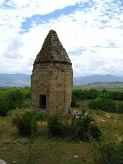
There are historical monuments in the territory of the rayon: a circular tower in Khadijally village, an octagonal mausoleum of Yahya ibn Muhammad al-Haj (1304–1305) in Məmmədbəyli village.[5]
On 20 October 2020, the President of Azerbaijan, Ilham Aliyev, announced that Azerbaijani military forces recaptured some settlements in Zangilan district, namely, Havali, Zarnali, Mammadbayli, Hakari, Sharifan, Mughanli villages, as well as Zangilan city itself.[6] On October 21, 2020, it was announced that Minjivan settlement and 12 more villages of Zangilan district have been recaptured.[7] Azerbaijani authorities announced the capture of 13 more villages and Aghband settlement of Zangilan district on October 22, 2020.[8] The recapture of Aghband settlement was highlighted for the reason that full control over the state border between Azerbaijan and Iran was established after the recapture.[9]
References
- "население азербайджана". www.ethno-kavkaz.narod.ru. Retrieved 11 October 2020.
- "Демоскоп Weekly - Приложение. Справочник статистических показателей". www.demoscope.ru (in Russian). Retrieved 11 October 2020.
- "ХРОНОЛОГИЯ АРМЯНО-АЗЕРБАЙДЖАНСКОГО КОНФЛИКТА". Embassy of the Republic of Azerbaijan in the People's Republic of China.
- "Карабах: История одной агрессии: Начало активных боевых действий и Ходжалинская трагедия - ЧАСТЬ VIII". 1news.az.
- "Памятники Зангеланского района". garabagh.net.
- "President Ilham Aliyev: Zangilan city and 6 villages of the district, 18 villages of Fuzuli, Jabrayil, and Khojavand districts liberated". Ministry of Defense of Azerbaijan. 20 October 2020.
- "President Ilham Aliyev: Azerbaijani Army liberated Minjivan settlement and 13 villages of Zangilan district". Azerbaijan State News Agency. Retrieved 2020-10-21.
- "President Ilham Aliyev: Azerbaijani Army liberated 13 villages and Aghband settlement of Zangilan district". Ministry of Defense of Azerbaijan. Retrieved 2020-10-22.
- "President Ilham Aliyev: With the liberation of Aghband settlement, taking full control over the Azerbaijani-Iranian state border was ensured". Ministry of Defense of Azerbaijan. Retrieved 2020-10-23.