Kalbajar District
Kalbajar District (Azerbaijani: Kəlbəcər rayonu) is a district in the western part of Azerbaijan.[2]
Kalbajar District | |
|---|---|
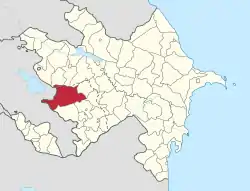 Map of Azerbaijan showing Kalbajar District | |
| Country | |
| Capital | Kalbajar |
| Area | |
| • Total | 3,050 km2 (1,180 sq mi) |
| Population (2010) | |
| • Total | 53,962 |
| Telephone code | (+994) 26[1] |
History
In Turkic Kalbajar means "Castle on the mouth of the river".[3] The city of Kalbajar was renamed to Karvachar (Armenian: Քարվաճառ) after its occupation, which corresponds to the ancient district of Vaykunik, one of 12 cantons of Artsakh (historical Nagorno-Karabakh).[4] It was also known as Upper-Khachen or Tsar (after its chief town) and was ruled by one of the branches of the House of Khachen, who held it until the Russian conquest of the Karabakh region in the early 19th century.[4] In 1992 Azerbaijani government abolished Mardakert district of NKAO, and its western part was included in Kelbajar district.[5]
Armenian occupation
As a result of the First Nagorno-Karabakh War, the area was occupied by Armenian forces on April 3, 1993. The district was declared a part of the self-proclaimed Republic of Artsakh, although it continued to be recognized by United Nations as a territory of the Republic of Azerbaijan.[6] The Azeri population of Kalbajar were displaced and lived as internally displaced persons in other regions of Azerbaijan. The district was made into the Shahumyan Province, one of the eight regions of NKR. The region remained the least populated of the NKR regions with a total population of 2,800. The town of Kalbajar was home to 500 Armenian residents.
Return to Azerbaijan
Under the terms of the agreement that ended the 2020 Nagorno-Karabakh War, most of the district (i.e. Kelbajar district within its Soviet time borders) returned to Azerbaijani control. The eastern part of the district, which was part of Martakert Province, remained under the control of the Republic of Artsakh. Initially, the western part was to be returned to Azerbaijani control by 15 November 2020, but this deadline was subsequently extended to 25 November 2020.[7][8] In the early hours of November 25, Azerbaijani forces entered the region; it was the second region to be returned to Azerbaijan per the ceasefire agreement.[9]
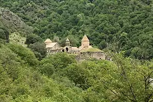
Cultural monuments
The district has close to 750 Armenian cultural monuments, which include monasteries, churches, chapels, fortresses, khachkars and inscriptions.[4] The most well-known is the monasteries of Dadivank and Gandzasar.[4]
Demographics
As of 1979 the region had a population of 40,516:[10]
- Azerbaijanis 99.5% (40,329)
- Armenians 0.1% (49)
- Lezgins 0.1% (30)
- Russians 0.1% (46)
The population grew to 43,713 by 1989.[11]
As of 1999, the population in the Kalbajar District (including part of the now-abolished Mardakert district) was 66,211 (the census was not carried out in this year as the region was occupied by the Republic of Artsakh and the Azerbaijani population was internally displaced at the time).[12]
- Azerbaijanis 83.2% (55,082)
- Armenians 14.8% (9,794)
- Lezgins 0,1% (9)
- Kurds 1.9% (1,248)
- Russians 0.1% (23)
- Other 0.1%(45)
During occupation
Starting in the early 2000s, the district was slowly repopulated by Armenian settlers from eastern Shahumyan and Gulustan area which fled during the First Nagorno-Karabakh War.[13]
According to 2005 Artsakh census, 2,560 Armenians were living in the western part of the Shahumyan Province, which roughly corresponded to the Soviet Kalbajar District.[14] Number gew to 2,800 by 2006.[15]
By 2015, the number of Armenians who had settled in the district had grown to 3,090.[16]
References
- "Şəhərlərarası telefon kodları". Aztelekom MMC. Aztelekom İB. Retrieved 19 August 2015. (in Azerbaijani)
- Государственный комитет по статистике Азербайджанской Республики — "Azərbaycanın regionları" (in Azerbaijani). Archived from the original on 2009-11-14.
- Институт научной информации (Академия наук СССР), Всесоюзный институт научной и технической информации. Реферативный журнал: География, Выпуски 5-6.. — Издательство Академии наук СССР, 1975. — С. 36.
- Robert H. Hewsen, Armenia: A Historical Atlas. The University of Chicago Press, 2001, pp. 40, 101-102, 264-265.
- "Государственный комитет по статистике Азербайджанской Республики". Archived from the original on 2009-11-14.
- UN Resolution 884
- "Azerbaijanis celebrate Karabakh deal". aa.com.tr. Anadolu Agency. 10 November 2020.
- "Азербайджан дал Армении отсрочку на вывод войск из Кельбаджара". РБК (in Russian). Retrieved 2020-11-15.
- "Azerbaijani Forces Enter Second District Returned By Armenia Under Nagorno-Karabakh Truce". RadioFreeEurope/RadioLiberty. Retrieved 2020-11-25.
- "население азербайджана". www.ethno-kavkaz.narod.ru. Retrieved 11 October 2020.
- "Демоскоп Weekly - Приложение. Справочник статистических показателей". www.demoscope.ru (in Russian). Retrieved 11 October 2020.
- "население азербайджана". www.ethno-kavkaz.narod.ru. Retrieved 11 October 2020.
- The Nagorno-Karabakh Conflict: A Legal Analysis. Heiko Krüger. Springer, 2010. ISBN 3642117872, 9783642117879. p. 102
- "THE RESULTS OF 2005 OF THE NAGORNO-KARABAGH REPUBLIC, Part 2, Chapter 1, Table 1.1 NKR De Facto and De Jure Population by Administrative Territorial Distribution and Sex" (PDF). p. 23. Retrieved 2020-02-01.
- "Statistical yearbook of NKR, Population" (PDF). Archived from the original (PDF) on October 2020. Retrieved 2009-03-27. Cite journal requires
|journal=(help) - "THE RESULTS OF 2015 POPULATION CENSUS OF THE NAGORNO-KARABAGH REPUBLIC, Chapter 2, Table 1.2 NKR de facto and de jure population (urban, rural) according to administrative-territorial division and residence status" (PDF). Retrieved 2020-02-01.