Kingsbridge Road station (IRT Jerome Avenue Line)
Kingsbridge Road is a local station on the elevated IRT Jerome Avenue Line of the New York City Subway. Located at the intersection of Kingsbridge Road and Jerome Avenue in Kingsbridge Heights, Bronx, it is served by the 4 train at all times. This station was constructed by the Interborough Rapid Transit Company as part of the Dual Contracts and opened in 1917.
Kingsbridge Road | ||||||||||||||||||||||||||||||||||||||||||||||||||||||||||||||||||||
|---|---|---|---|---|---|---|---|---|---|---|---|---|---|---|---|---|---|---|---|---|---|---|---|---|---|---|---|---|---|---|---|---|---|---|---|---|---|---|---|---|---|---|---|---|---|---|---|---|---|---|---|---|---|---|---|---|---|---|---|---|---|---|---|---|---|---|---|---|
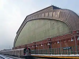 Platform view, with Kingsbridge Armory | ||||||||||||||||||||||||||||||||||||||||||||||||||||||||||||||||||||
| Station statistics | ||||||||||||||||||||||||||||||||||||||||||||||||||||||||||||||||||||
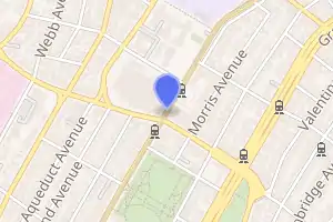
| Address | Kingsbridge Road & Jerome Avenue Bronx, NY 10468[1] | |||||||||||||||||||||||||||||||||||||||||||||||||||||||||||||||||||
| Borough | The Bronx | |||||||||||||||||||||||||||||||||||||||||||||||||||||||||||||||||||
| Locale | Kingsbridge Heights, Fordham | |||||||||||||||||||||||||||||||||||||||||||||||||||||||||||||||||||
| Coordinates | 40°52′04″N 73°53′50″W | |||||||||||||||||||||||||||||||||||||||||||||||||||||||||||||||||||
| Division | A (IRT) | |||||||||||||||||||||||||||||||||||||||||||||||||||||||||||||||||||
| Line | IRT Jerome Avenue Line | |||||||||||||||||||||||||||||||||||||||||||||||||||||||||||||||||||
| Services | 4 | |||||||||||||||||||||||||||||||||||||||||||||||||||||||||||||||||||
| Transit | ||||||||||||||||||||||||||||||||||||||||||||||||||||||||||||||||||||
| Structure | Elevated | |||||||||||||||||||||||||||||||||||||||||||||||||||||||||||||||||||
| Platforms | 2 side platforms | |||||||||||||||||||||||||||||||||||||||||||||||||||||||||||||||||||
| Tracks | 3 (2 in regular service) | |||||||||||||||||||||||||||||||||||||||||||||||||||||||||||||||||||
| Other information | ||||||||||||||||||||||||||||||||||||||||||||||||||||||||||||||||||||
| Opened | June 2, 1917 | |||||||||||||||||||||||||||||||||||||||||||||||||||||||||||||||||||
| Station code | 381[3] | |||||||||||||||||||||||||||||||||||||||||||||||||||||||||||||||||||
| Accessible | not ADA-accessible; accessibility planned | |||||||||||||||||||||||||||||||||||||||||||||||||||||||||||||||||||
| Opposite- direction transfer | Yes | |||||||||||||||||||||||||||||||||||||||||||||||||||||||||||||||||||
| Traffic | ||||||||||||||||||||||||||||||||||||||||||||||||||||||||||||||||||||
| 2019 | 2,733,096[4] | |||||||||||||||||||||||||||||||||||||||||||||||||||||||||||||||||||
| Rank | 179 out of 424[4] | |||||||||||||||||||||||||||||||||||||||||||||||||||||||||||||||||||
| Station succession | ||||||||||||||||||||||||||||||||||||||||||||||||||||||||||||||||||||
| Next north | Bedford Park Boulevard–Lehman College: 4 | |||||||||||||||||||||||||||||||||||||||||||||||||||||||||||||||||||
| Next south | Fordham Road: 4 | |||||||||||||||||||||||||||||||||||||||||||||||||||||||||||||||||||
| ||||||||||||||||||||||||||||||||||||||||||||||||||||||||||||||||||||
| ||||||||||||||||||||||||||||||||||||||||||||||||||||||||||||||||||||
| ||||||||||||||||||||||||||||||||||||||||||||||||||||||||||||||||||||
| ||||||||||||||||||||||||||||||||||||||||||||||||||||||||||||||||||||

History
Construction and opening
The Dual Contracts, which were signed on March 19, 1913, were contracts for the construction and/or rehabilitation and operation of rapid transit lines in the City of New York. The contracts were "dual" in that they were signed between the City and two separate private companies (the Interborough Rapid Transit Company and the Brooklyn Rapid Transit Company), all working together to make the construction of the Dual Contracts possible. The Dual Contracts promised the construction of several lines in the Bronx. As part of Contract 3, the IRT agreed to build an elevated line along Jerome Avenue in the Bronx.[5][6][7]
Kingsbridge Road station opened as the northern terminal of the initial section of the line on June 2, 1917. Service was initially operated as a shuttle between Kingsbridge Road and 149th Street, and only the southbound platform was in use at this station.[8][9] Through service to the IRT Lexington Avenue Line began on July 17, 1918.[10] This station ceased to be the terminal of the line with the opening of the final extension to Woodlawn on April 15, 1918.[11] This section was initially served by shuttle service, with passengers transferring at 167th Street.[12][13] The construction of the line encouraged development along Jerome Avenue, and led to the growth of the surrounding communities.[8]
Later years
In May 2018, New York City Transit Authority President Andy Byford announced his plan subway and bus modernization plan, known as Fast Forward, which included making an additional 50 stations compliant with the Americans with Disabilities Act of 1990 during the 2020–2024 Metropolitan Transportation Authority (MTA) Capital Program to allow most riders to have an accessible station every two or three stops.[14][15] The draft 2020–2024 Capital Program released in September 2019 included 66 stations that would receive ADA improvements.[16] In December, the MTA announced that an additional twenty stations, including Kingsbridge Road, would be made ADA-accessible as part of the Capital Program.[17][18]
Station layout
| P Platform level |
Side platform | |
| Northbound local | ← | |
| Peak-direction express | No regular service | |
| Southbound local | | |
| Side platform | ||
| M | Mezzanine | Fare control, station agent, MetroCard machines |
| G | Street level | Entrances/exits |
The station has three tracks and two side platforms.[19] The 4 stops here at all times.[20] The middle track is generally not used in revenue service. It is a typical IRT elevated station.[19] The Kingsbridge Armory rises immediately to the west of the station.[21]
References
- "Borough of The Bronx, New York City". Government of New York City. Retrieved December 28, 2020.
- "Bronx Bus Map" (PDF). Metropolitan Transportation Authority. October 2018. Retrieved December 1, 2020.
- "Station Developers' Information". Metropolitan Transportation Authority. Retrieved June 13, 2017.
- "Facts and Figures: Annual Subway Ridership 2014–2019". Metropolitan Transportation Authority. 2020. Retrieved May 26, 2020.
- New Subways For New York: The Dual System of Rapid Transit Chapter 5: Terms and Conditions of Dual System Contracts. New York Public Service Commission. 1913. Retrieved February 16, 2015.
- The Dual System of Rapid Transit (1912). New York State Public Service Commission. 1912.
- "Most Recent Map of the Dual Subway System Which Shows How Brooklyn Borough Is Favored In New Transit Lines". The Brooklyn Daily Eagle. September 9, 1917. Retrieved August 23, 2016 – via newspapers.com.

- "Service Begun on the Jerome Avenue Line". Public Service Record. 4 (6). June 1917.
- Annual report of the Interborough Rapid Transit Company For The Year Ended June 30, 1917. HathiTrust. Interborough Rapid Transit Company. 1917. hdl:2027/mdp.39015016416920.
- Brooklyn Daily Eagle Almanac. The Brooklyn Daily Eagle. 1922. p. 372.
- "Jerome Av. Line Ordered Opened". The New York Times. April 13, 1918. ISSN 0362-4331. Retrieved June 5, 2016.
- Brooklyn Daily Eagle Almanac. The Brooklyn Daily Eagle. 1916. p. 100.
- Cunningham, Joseph; DeHart, Leonard O. (1993). A History of the New York City Subway System. J. Schmidt, R. Giglio, and K. Lang. p. 48.
- "A Sweeping Plan to Fix the Subways Comes With a $19 Billion Price Tag". The New York Times. May 22, 2018. ISSN 0362-4331. Retrieved May 23, 2018.
- "Transform the Subway" (PDF). Fast Forward. Metropolitan Transportation Authority. May 23, 2018. p. 41. Retrieved May 23, 2018.
- Guse, Clayton (September 16, 2019). "MTA announces $51 billion plan to save the subway, treat NYC's transit sickness". New York Daily News. Retrieved September 16, 2019.
- "MTA Announces 20 Additional Subway Stations to Receive Accessibility Improvements Under Proposed 2020-2024 Capital Plan". mta.info. Metropolitan Transportation Authority. December 19, 2019. Retrieved December 20, 2019.
- Barone, Vincent (December 19, 2019). "MTA unveils nearly full list of subway stations to receive elevators". amNewYork. Retrieved December 20, 2019.
- Dougherty, Peter (2020). Tracks of the New York City Subway 2020 (16th ed.). Dougherty. OCLC 1056711733.
- "4 Subway Timetable, Effective September 13, 2020". Metropolitan Transportation Authority. Retrieved December 9, 2020.
- "Kingsbridge Road Neighborhood Map" (PDF). new.mta.info. Metropolitan Transportation Authority. April 2018. Retrieved February 28, 2019.
External links
| Wikimedia Commons has media related to Kingsbridge Road (IRT Jerome Avenue Line). |
- nycsubway.org – IRT Woodlawn Line: Kingsbridge Road
- nycsubway.org — Urban Motif Artwork by Mario M. Muller (2006)
- Station Reporter — 4 Train
- The Subway Nut — Kingsbridge Road Pictures
- MTA's Arts For Transit — Kingsbridge Road (IRT Jerome Avenue Line)
- Kingsbridge Road entrance from Google Maps Street View
- Platforms from Google Maps Street View
| Jerome Ave. Line |
|
|---|---|
| |