86th Street station (IRT Lexington Avenue Line)
86th Street is an express station on the IRT Lexington Avenue Line of the New York City Subway. Located at the intersection of Lexington Avenue and 86th Street on the Upper East Side, it is served by the 4 and 6 trains at all times, the 5 train at all times except late nights, and the <6> train during weekdays in peak direction. This station was constructed as part of the Dual Contracts by the Interborough Rapid Transit Company and opened in 1918.
86 Street | ||||||||||||||||||||||||||||||||||||||||||||||||||||||||||||||||||||||||||||||||||||||||||||||||||||||||||||||||||||||||||||||||||||||||||||||||||||||||||||||||||
|---|---|---|---|---|---|---|---|---|---|---|---|---|---|---|---|---|---|---|---|---|---|---|---|---|---|---|---|---|---|---|---|---|---|---|---|---|---|---|---|---|---|---|---|---|---|---|---|---|---|---|---|---|---|---|---|---|---|---|---|---|---|---|---|---|---|---|---|---|---|---|---|---|---|---|---|---|---|---|---|---|---|---|---|---|---|---|---|---|---|---|---|---|---|---|---|---|---|---|---|---|---|---|---|---|---|---|---|---|---|---|---|---|---|---|---|---|---|---|---|---|---|---|---|---|---|---|---|---|---|---|---|---|---|---|---|---|---|---|---|---|---|---|---|---|---|---|---|---|---|---|---|---|---|---|---|---|---|---|---|---|---|---|
 Downtown local platform | ||||||||||||||||||||||||||||||||||||||||||||||||||||||||||||||||||||||||||||||||||||||||||||||||||||||||||||||||||||||||||||||||||||||||||||||||||||||||||||||||||
| Station statistics | ||||||||||||||||||||||||||||||||||||||||||||||||||||||||||||||||||||||||||||||||||||||||||||||||||||||||||||||||||||||||||||||||||||||||||||||||||||||||||||||||||
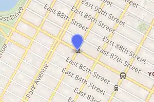
| Address | East 86th Street & Lexington Avenue New York, NY 10028[1] | |||||||||||||||||||||||||||||||||||||||||||||||||||||||||||||||||||||||||||||||||||||||||||||||||||||||||||||||||||||||||||||||||||||||||||||||||||||||||||||||||
| Borough | Manhattan | |||||||||||||||||||||||||||||||||||||||||||||||||||||||||||||||||||||||||||||||||||||||||||||||||||||||||||||||||||||||||||||||||||||||||||||||||||||||||||||||||
| Locale | Upper East Side | |||||||||||||||||||||||||||||||||||||||||||||||||||||||||||||||||||||||||||||||||||||||||||||||||||||||||||||||||||||||||||||||||||||||||||||||||||||||||||||||||
| Coordinates | 40.779469°N 73.955626°W | |||||||||||||||||||||||||||||||||||||||||||||||||||||||||||||||||||||||||||||||||||||||||||||||||||||||||||||||||||||||||||||||||||||||||||||||||||||||||||||||||
| Division | A (IRT) | |||||||||||||||||||||||||||||||||||||||||||||||||||||||||||||||||||||||||||||||||||||||||||||||||||||||||||||||||||||||||||||||||||||||||||||||||||||||||||||||||
| Line | IRT Lexington Avenue Line | |||||||||||||||||||||||||||||||||||||||||||||||||||||||||||||||||||||||||||||||||||||||||||||||||||||||||||||||||||||||||||||||||||||||||||||||||||||||||||||||||
| Services | 4 5 6 | |||||||||||||||||||||||||||||||||||||||||||||||||||||||||||||||||||||||||||||||||||||||||||||||||||||||||||||||||||||||||||||||||||||||||||||||||||||||||||||||||
| Transit | ||||||||||||||||||||||||||||||||||||||||||||||||||||||||||||||||||||||||||||||||||||||||||||||||||||||||||||||||||||||||||||||||||||||||||||||||||||||||||||||||||
| Structure | Underground | |||||||||||||||||||||||||||||||||||||||||||||||||||||||||||||||||||||||||||||||||||||||||||||||||||||||||||||||||||||||||||||||||||||||||||||||||||||||||||||||||
| Levels | 2 | |||||||||||||||||||||||||||||||||||||||||||||||||||||||||||||||||||||||||||||||||||||||||||||||||||||||||||||||||||||||||||||||||||||||||||||||||||||||||||||||||
| Platforms | 4 side platforms (2 on each level) | |||||||||||||||||||||||||||||||||||||||||||||||||||||||||||||||||||||||||||||||||||||||||||||||||||||||||||||||||||||||||||||||||||||||||||||||||||||||||||||||||
| Tracks | 4 (2 on each level) | |||||||||||||||||||||||||||||||||||||||||||||||||||||||||||||||||||||||||||||||||||||||||||||||||||||||||||||||||||||||||||||||||||||||||||||||||||||||||||||||||
| Other information | ||||||||||||||||||||||||||||||||||||||||||||||||||||||||||||||||||||||||||||||||||||||||||||||||||||||||||||||||||||||||||||||||||||||||||||||||||||||||||||||||||
| Opened | July 17, 1918[3] | |||||||||||||||||||||||||||||||||||||||||||||||||||||||||||||||||||||||||||||||||||||||||||||||||||||||||||||||||||||||||||||||||||||||||||||||||||||||||||||||||
| Station code | 397[4] | |||||||||||||||||||||||||||||||||||||||||||||||||||||||||||||||||||||||||||||||||||||||||||||||||||||||||||||||||||||||||||||||||||||||||||||||||||||||||||||||||
| Accessible | ||||||||||||||||||||||||||||||||||||||||||||||||||||||||||||||||||||||||||||||||||||||||||||||||||||||||||||||||||||||||||||||||||||||||||||||||||||||||||||||||||
| Opposite- direction transfer | No | |||||||||||||||||||||||||||||||||||||||||||||||||||||||||||||||||||||||||||||||||||||||||||||||||||||||||||||||||||||||||||||||||||||||||||||||||||||||||||||||||
| Traffic | ||||||||||||||||||||||||||||||||||||||||||||||||||||||||||||||||||||||||||||||||||||||||||||||||||||||||||||||||||||||||||||||||||||||||||||||||||||||||||||||||||
| 2019 | 13,537,308[5] | |||||||||||||||||||||||||||||||||||||||||||||||||||||||||||||||||||||||||||||||||||||||||||||||||||||||||||||||||||||||||||||||||||||||||||||||||||||||||||||||||
| Rank | 21 out of 424[5] | |||||||||||||||||||||||||||||||||||||||||||||||||||||||||||||||||||||||||||||||||||||||||||||||||||||||||||||||||||||||||||||||||||||||||||||||||||||||||||||||||
| Station succession | ||||||||||||||||||||||||||||||||||||||||||||||||||||||||||||||||||||||||||||||||||||||||||||||||||||||||||||||||||||||||||||||||||||||||||||||||||||||||||||||||||
| Next north | 125th Street (express): 4 96th Street (local): 4 | |||||||||||||||||||||||||||||||||||||||||||||||||||||||||||||||||||||||||||||||||||||||||||||||||||||||||||||||||||||||||||||||||||||||||||||||||||||||||||||||||
| Next south | 77th Street (local): 4 59th Street (express): 4 | |||||||||||||||||||||||||||||||||||||||||||||||||||||||||||||||||||||||||||||||||||||||||||||||||||||||||||||||||||||||||||||||||||||||||||||||||||||||||||||||||
| ||||||||||||||||||||||||||||||||||||||||||||||||||||||||||||||||||||||||||||||||||||||||||||||||||||||||||||||||||||||||||||||||||||||||||||||||||||||||||||||||||
| ||||||||||||||||||||||||||||||||||||||||||||||||||||||||||||||||||||||||||||||||||||||||||||||||||||||||||||||||||||||||||||||||||||||||||||||||||||||||||||||||||
| ||||||||||||||||||||||||||||||||||||||||||||||||||||||||||||||||||||||||||||||||||||||||||||||||||||||||||||||||||||||||||||||||||||||||||||||||||||||||||||||||||
| ||||||||||||||||||||||||||||||||||||||||||||||||||||||||||||||||||||||||||||||||||||||||||||||||||||||||||||||||||||||||||||||||||||||||||||||||||||||||||||||||||
86th Street Subway Station (Dual System IRT) | ||||||||||||||||||||||||||||||||||||||||||||||||||||||||||||||||||||||||||||||||||||||||||||||||||||||||||||||||||||||||||||||||||||||||||||||||||||||||||||||||||
| MPS | New York City Subway System MPS | |||||||||||||||||||||||||||||||||||||||||||||||||||||||||||||||||||||||||||||||||||||||||||||||||||||||||||||||||||||||||||||||||||||||||||||||||||||||||||||||||
| NRHP reference No. | 05000236[6] | |||||||||||||||||||||||||||||||||||||||||||||||||||||||||||||||||||||||||||||||||||||||||||||||||||||||||||||||||||||||||||||||||||||||||||||||||||||||||||||||||
| Added to NRHP | March 30, 2005 | |||||||||||||||||||||||||||||||||||||||||||||||||||||||||||||||||||||||||||||||||||||||||||||||||||||||||||||||||||||||||||||||||||||||||||||||||||||||||||||||||

History
Construction and opening
Following the completion of the original subway, there were plans to construct a line along Manhattan's east side north of 42nd Street. The original plan for what became the extension north of 42nd Street was to continue it south through Irving Place and into what is now the BMT Broadway Line at Ninth Street and Broadway. In July 1911, the IRT had withdrawn from the talks, and the Brooklyn Rapid Transit Company (BRT) was to operate on Lexington Avenue. The IRT submitted an offer for what became its portion of the Dual Contracts on February 27, 1912.[7][8]
In 1913, as part of the Dual Contracts, which were signed on March 19, 1913,[9] the Public Service Commission planned to split the original Interborough Rapid Transit Company (IRT) system from looking like a "Z" system (as seen on a map) to an "H"-shaped system. The original system would be split into three segments: two north–south lines, carrying through trains over the Lexington Avenue and Broadway–Seventh Avenue Lines, and a west–east shuttle under 42nd Street. This would form a roughly "H"-shaped system.[10][11] It was predicted that the subway extension would lead to the growth of the Upper East Side and the Bronx.[12][13]
86th Street station opened on July 17, 1918, with service initially running between Grand Central–42nd Street station and 167th Street via the line's local tracks.[3] On August 1, the "H system" was put into place, with through service beginning on the new east and west side trunk lines, and the institution of the 42nd Street Shuttle along the old connection between the sides. The station's lower level opened on this date with the inauguration of express service.[14] The cost of the extension from Grand Central was $58 million.[15]
Station renovations
In late 1959, contracts were awarded to extend the platforms at Bowling Green, Wall Street, Fulton Street, Canal Street, Spring Street, Bleecker Street, Astor Place, Grand Central, 86th Street and 125th Street to 525 feet (160 m) to accommodate ten-car trains.[16]
In the early 1970s, the station was renovated with the opening of a Gimbels department store directly above. The renovation took place mostly in the fare control areas. The station was renovated again in 1986 as part of a move to prevent the existing New York City Subway stations from falling apart after years of deferred maintenance; this is evidenced by the addition of the then standard orange platform edge in addition to the yellow platform edge that was originally there, as well as painting the I Beams red instead of the original blue and fixing all the other parts of the station.[17]
In fall 2004, another station renovation project was completed.[18] It consisted of repainting the I-beams from red to dark blue, as well as the removal of train arrival devices on the upper level that gave notices of approaching express trains on the lower level, among other things; the latter was replaced with countdown clocks, on both levels, which performed the same function.[19][20]
This station was added to the National Register of Historic Places on March 30, 2005.[21]
Station layout
| G | Street level | Exit/entrance |
| B1 | Fare control for northbound platforms | |
| Side platform | ||
| Northbound local | ← ← | |
| Southbound local | | |
| Side platform | ||
| Fare control for southbound platforms | ||
| B2 | Side platform | |
| Northbound express | ← ← | |
| Southbound express | | |
| Side platform | ||
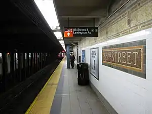
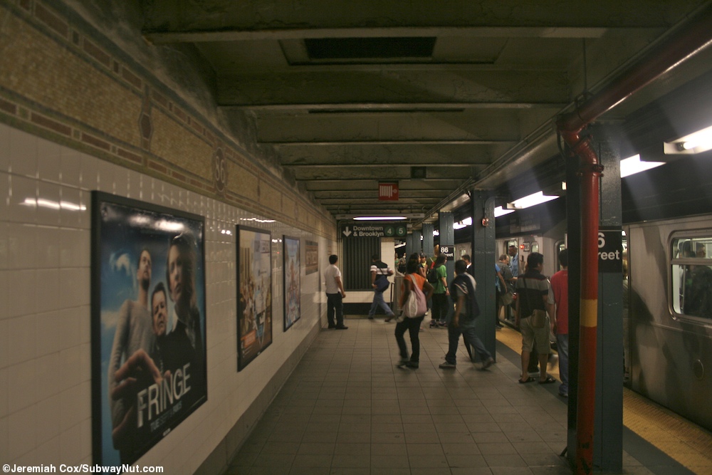
This underground station has two levels. Each level has two tracks and two side platforms. The upper level serves local trains while the lower level, located approximately 48 feet (15 m) below ground, serves express trains.[22][23] The 4 and 6 stop here at all times, and the 5 stops here at all times except late nights.[24][25] [26] There is no express service during late nights and the lower level is closed during that period.[22] Four staircases connect the levels on each side.
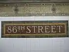
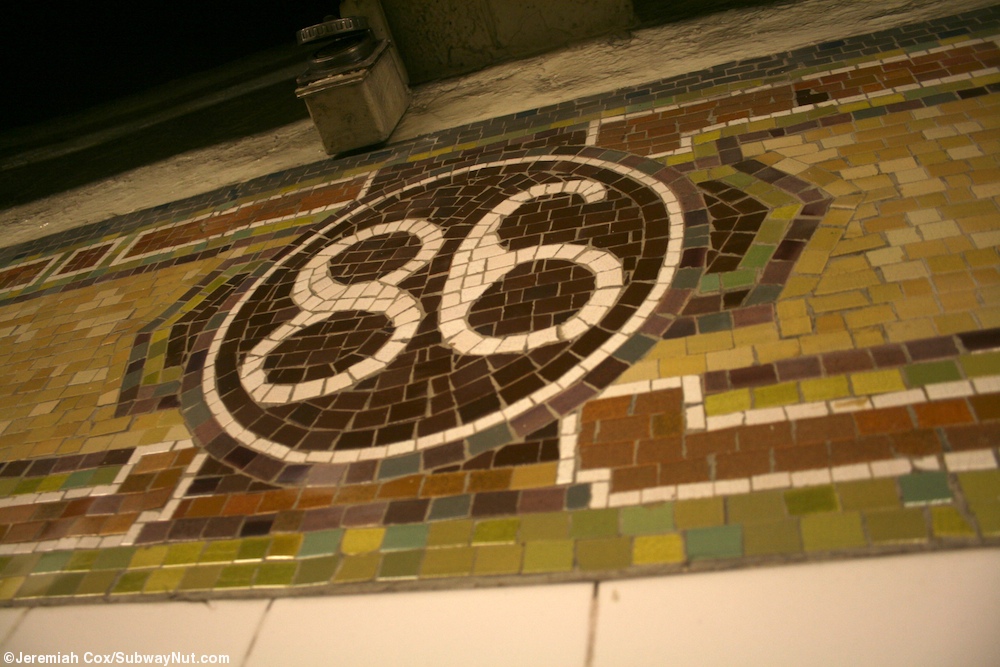
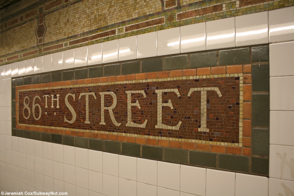
There are no crossovers or crossunders between the platforms, making this one of only two express stations in the system where free transfers between opposite directions are not possible (the other is Bergen Street, whose lower level is closed, on the IND Culver Line). Each platform has its original Dual Contracts trim line consisting mostly of yellows and browns. Small "86" tablets in a circle run along this trim line.[27] The name tablets have "86TH STREET" in a white serif font on a reddish-brown background with a light-brown inner border and green outer border.[28] Teal columns run along all four platforms at regular intervals.[29]

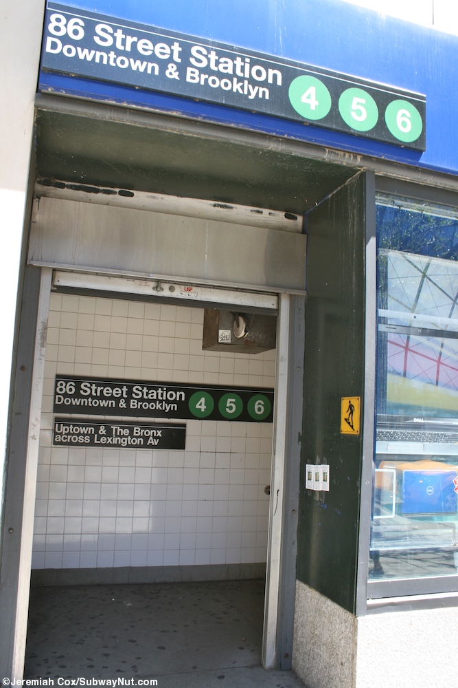
Each upper-level platform has one same-level fare control area in the center. The southbound side has a turnstile bank, token booth, two staircases going up to the southwest corner of East 86th Street and Lexington Avenue, and two more that are built inside a Best Buy store on the northwest corner of the same intersection.[30] The northbound fare control has an unstaffed turnstile bank and two staircases going up to the southeast corner of East 86th Street and Lexington Avenue. An additional staircase and an elevator rise to the northeast corner. The elevator and staircase replace two narrow staircases formerly located inside a now-demolished shopping arcade at that corner. The elevator and staircase installations are part of the construction of a luxury residential tower at 147 East 86th Street.[31][32]
As of 2019, only the northbound local platform is ADA-accessible, since there is no elevator from the local platform to the express platform and no elevators on the southbound side. Accessibility of the entire station was proposed in August 2019 as part of the MTA's "Fast Forward" program.[33]
The 2004 artwork here is called Happy City by Peter Sis. It consists of four different glass and etched stone mosaic murals in the shapes of huge eyes surrounded by various animals and objects. They are located at each stop of the four staircases near the fare control areas that go down to the lower level express platforms.[34]
Exits
| Exit location[35] | Exit type | Number of exits | Platform served |
|---|---|---|---|
| NW corner of Lexington Avenue and 86th Street | Staircase | 2 | Southbound |
| SW corner of Lexington Avenue and 86th Street | Staircase | 2 | Southbound |
| NE corner of Lexington Avenue and 86th Street | Staircase | 1 | Northbound |
| SE corner of Lexington Avenue and 86th Street | Staircase | 2 | Northbound |
Notable places nearby
References
- "Borough of Manhattan, New York City". Government of New York City. Retrieved December 28, 2020.
- "Manhattan Bus Map" (PDF). Metropolitan Transportation Authority. July 2019. Retrieved December 1, 2020.
- "Lexington Av. Line to be Opened Today" (PDF). The New York Times. July 17, 1918. p. 13. ISSN 0362-4331. Retrieved April 21, 2020.
- "Station Developers' Information". Metropolitan Transportation Authority. Retrieved June 13, 2017.
- "Facts and Figures: Annual Subway Ridership 2014–2019". Metropolitan Transportation Authority. 2020. Retrieved May 26, 2020.
- "NPS Focus". National Register of Historic Places. National Park Service. Retrieved November 6, 2011.
- Walker, James Blaine (1918). Fifty Years of Rapid Transit — 1864 to 1917. New York, N.Y.: Law Printing. pp. 230–233. Retrieved November 6, 2016.
- "Petition for Subway in Lexington Ave". The New York Times. May 22, 1912. ISSN 0362-4331. Retrieved February 16, 2009.
A petition is being circulated among the residents and property owners of the section just south of the Grand Central Station, in Park and Lexington Avenues, protesting against the proposed abandonment of the construction of the Subway in Lexington Avenue, between Forty-third and Thirty-second Streets.
- "Subway Contracts Solemnly Signed; Cheers at the Ceremonial Function When McCall Gets Willcox to Attest" (PDF). The New York Times. March 20, 1913. ISSN 0362-4331. Retrieved January 11, 2018.
- "Money Set Aside For New Subways; Board of Estimate Approves City Contracts to be Signed To-day with Interboro and B.R.T." (PDF). The New York Times. March 19, 1913. ISSN 0362-4331. Retrieved November 10, 2017.
- Engineering News-record. McGraw-Hill Publishing Company. 1916. p. 846.
- Whitney, Travis H. (March 10, 1918). "The Seventh and Lexington Avenue Subways Will Revive Dormant Sections — Change in Operation That Will Transform Original Four-Tracked Subway Into Two Four-Tracked Systems and Double Present Capacity of the Interborough". The New York Times. p. 12. Retrieved August 26, 2016.
- "Public Service Commission Fixes July 15 For Opening of The New Seventh and Lexington Avenue Subway Lines — Will Afford Better Service and Less Crowding — Shuttle Service for Forty-Second Street — How the Various Lines of the Dual System Are Grouped for Operation and List of Stations on All Lines". The New York Times. May 19, 1918. p. 32. Retrieved November 6, 2016.
- "Open New Subway Lines to Traffic; Called a Triumph — Great H System Put in Operation Marks an Era in Railroad Construction — No Hitch in the Plans — But Public Gropes Blindly to Find the Way in Maze of New Stations — Thousands Go Astray — Leaders in City's Life Hail Accomplishment of Great Task at Meeting at the Astor". The New York Times. August 2, 1918. p. 1. Retrieved November 6, 2016.
- "Finish a New Link of the Dual Subway; Lexington Avenue Line North of Forty-second Street to Begin Local Service Wednesday. Branch Extends to Bronx Through service, with Times SquareGrand Central Shuttle Connections, to Open Soon. Changes in the Bronx". The New York Times. July 11, 1918. p. 20. ISSN 0362-4331. Retrieved January 8, 2017.
- Annual Report For The Year Ending June 30, 1959 (PDF). New York City Transit Authority. 1959. p. 9.
- Oszustowicz, Eric (November 8, 1987). "View of the downtown express platform". nycsubway.org. Retrieved December 28, 2020.
- Jeremiah Cox. "86 Street (4,5,6) - The SubwayNut". subwaynut.com.
- "Learn More about Countdown Clocks..." mta.info. Metropolitan Transportation Authority. Retrieved October 31, 2011.
- "Countdown Clocks Station List". mta.info. Metropolitan Transportation Authority. Retrieved October 31, 2011.
- "National Register of Historical Places - NEW YORK (NY), New York County". www.nationalregisterofhistoricplaces.com. Retrieved August 4, 2017.
- Dougherty, Peter (2006) [2002]. Tracks of the New York City Subway 2006 (3rd ed.). Dougherty. OCLC 49777633 – via Google Books.
- Metropolitan Transportation Authority. "Second Avenue Subway March 2014 Public Workshop Follow-Up Report, page 23" (PDF). Retrieved April 21, 2016.
- "4 Subway Timetable, Effective September 13, 2020". Metropolitan Transportation Authority. Retrieved December 9, 2020.
- "5 Subway Timetable, Effective September 13, 2020". Metropolitan Transportation Authority. Retrieved December 9, 2020.
- "6 Subway Timetable, Effective September 13, 2020". Metropolitan Transportation Authority. Retrieved December 9, 2020.
- Cox, Jeremiah (August 15, 2008). "Close-up of 86 in the trimline". subwaynut.com. Retrieved August 4, 2017.
- Cox, Jeremiah (August 12, 2011). "A name tablet". subwaynut.com. Retrieved August 4, 2017.
- Cox, Jeremiah (August 15, 2008). "Passengers get off a downtown 6 train". subwaynut.com. Retrieved August 4, 2017.
- Cox, Jeremiah (August 12, 2011). "One of the entrances inside the storefront of Best Buy". subwaynut.com. Retrieved August 4, 2017.
- Zimmer, Amy (March 21, 2016). "MTA's Deal With Developer to Alter 86th St. Subway Station Angers Locals". DNAinfo New York. Archived from the original on May 16, 2018. Retrieved May 16, 2018.
- Weaver, Shaye (June 16, 2017). "Developer to Create 'Obstacle Course' With New UES Subway Entrances: Locals". DNAinfo New York. Archived from the original on May 16, 2018. Retrieved May 16, 2018.
- Berger, Paul. "MTA Has a Target List of Accessible Stations but Stalls Release". WSJ. Retrieved August 2, 2019.
- "Fast Forward Station Groupings List". Metropolitan Transportation Authority. Retrieved August 2, 2019 – via Wall Street Journal.
- "Fast Forward Station Groupings List". Metropolitan Transportation Authority. Retrieved August 2, 2019 – via Wall Street Journal.
- "NYCT Permanent Art". mta.info. Metropolitan Transportation Authority. Retrieved August 4, 2017.
- "86th Street Neighborhood Map". mta.info. Metropolitan Transportation Authority. April 2018. Retrieved December 28, 2020.
External links
| Wikimedia Commons has media related to 86th Street (IRT Lexington Avenue Line). |
- nycsubway.org – IRT East Side Line: 86th Street
- nycsubway.org — Happy City Artwork by Peter Sis (2004)
- MTA's Arts For Transit — 86th Street (IRT Lexington Avenue Line)
- 86th Street northbound entrance from Google Maps Street View
- 86th Street southbound entrance from Google Maps Street View
- Platforms from Google Maps Street View
| Lexington Ave. Line |
|
|---|---|
| |
| Topics |  | |
|---|---|---|
| Lists by county |
| |
| Lists by city | ||
| Other lists | ||
| ||