Astor Place station
Astor Place, also called Astor Place–Cooper Union on signs, is a local station on the IRT Lexington Avenue Line of the New York City Subway. Located at Fourth Avenue, Cooper Square, and Astor Place between the East Village and NoHo, it is served by 6 trains at all times, <6> trains during weekdays in the peak direction, and 4 trains during late night hours.
Astor Place | |||||||||||||||||||||||||||||||||||||||||||||||||||||||||||||||||||||||||||||||||||||||||
|---|---|---|---|---|---|---|---|---|---|---|---|---|---|---|---|---|---|---|---|---|---|---|---|---|---|---|---|---|---|---|---|---|---|---|---|---|---|---|---|---|---|---|---|---|---|---|---|---|---|---|---|---|---|---|---|---|---|---|---|---|---|---|---|---|---|---|---|---|---|---|---|---|---|---|---|---|---|---|---|---|---|---|---|---|---|---|---|---|---|
 Downtown platform | |||||||||||||||||||||||||||||||||||||||||||||||||||||||||||||||||||||||||||||||||||||||||
| Station statistics | |||||||||||||||||||||||||||||||||||||||||||||||||||||||||||||||||||||||||||||||||||||||||
| Address | Astor Place & Lafayette Street New York, NY 10003[1][2]:1 | ||||||||||||||||||||||||||||||||||||||||||||||||||||||||||||||||||||||||||||||||||||||||
| Borough | Manhattan | ||||||||||||||||||||||||||||||||||||||||||||||||||||||||||||||||||||||||||||||||||||||||
| Locale | NoHo / East Village | ||||||||||||||||||||||||||||||||||||||||||||||||||||||||||||||||||||||||||||||||||||||||
| Coordinates | 40°43′47″N 73°59′30″W | ||||||||||||||||||||||||||||||||||||||||||||||||||||||||||||||||||||||||||||||||||||||||
| Division | A (IRT) | ||||||||||||||||||||||||||||||||||||||||||||||||||||||||||||||||||||||||||||||||||||||||
| Line | IRT Lexington Avenue Line | ||||||||||||||||||||||||||||||||||||||||||||||||||||||||||||||||||||||||||||||||||||||||
| Services | 4 6 | ||||||||||||||||||||||||||||||||||||||||||||||||||||||||||||||||||||||||||||||||||||||||
| Transit | |||||||||||||||||||||||||||||||||||||||||||||||||||||||||||||||||||||||||||||||||||||||||
| Structure | Underground | ||||||||||||||||||||||||||||||||||||||||||||||||||||||||||||||||||||||||||||||||||||||||
| Platforms | 2 side platforms | ||||||||||||||||||||||||||||||||||||||||||||||||||||||||||||||||||||||||||||||||||||||||
| Tracks | 4 | ||||||||||||||||||||||||||||||||||||||||||||||||||||||||||||||||||||||||||||||||||||||||
| Other information | |||||||||||||||||||||||||||||||||||||||||||||||||||||||||||||||||||||||||||||||||||||||||
| Opened | October 27, 1904[3] | ||||||||||||||||||||||||||||||||||||||||||||||||||||||||||||||||||||||||||||||||||||||||
| Station code | 407[4] | ||||||||||||||||||||||||||||||||||||||||||||||||||||||||||||||||||||||||||||||||||||||||
| Accessible | |||||||||||||||||||||||||||||||||||||||||||||||||||||||||||||||||||||||||||||||||||||||||
| Opposite- direction transfer | No | ||||||||||||||||||||||||||||||||||||||||||||||||||||||||||||||||||||||||||||||||||||||||
| Former/other names | Astor Place–Cooper Union Cooper Union | ||||||||||||||||||||||||||||||||||||||||||||||||||||||||||||||||||||||||||||||||||||||||
| Traffic | |||||||||||||||||||||||||||||||||||||||||||||||||||||||||||||||||||||||||||||||||||||||||
| 2019 | 5,502,925[5] | ||||||||||||||||||||||||||||||||||||||||||||||||||||||||||||||||||||||||||||||||||||||||
| Rank | 81 out of 424[5] | ||||||||||||||||||||||||||||||||||||||||||||||||||||||||||||||||||||||||||||||||||||||||
| Station succession | |||||||||||||||||||||||||||||||||||||||||||||||||||||||||||||||||||||||||||||||||||||||||
| Next north | 14th Street–Union Square: 4 | ||||||||||||||||||||||||||||||||||||||||||||||||||||||||||||||||||||||||||||||||||||||||
| Next south | Bleecker Street: 4 | ||||||||||||||||||||||||||||||||||||||||||||||||||||||||||||||||||||||||||||||||||||||||
| |||||||||||||||||||||||||||||||||||||||||||||||||||||||||||||||||||||||||||||||||||||||||
| |||||||||||||||||||||||||||||||||||||||||||||||||||||||||||||||||||||||||||||||||||||||||
| |||||||||||||||||||||||||||||||||||||||||||||||||||||||||||||||||||||||||||||||||||||||||
| |||||||||||||||||||||||||||||||||||||||||||||||||||||||||||||||||||||||||||||||||||||||||
Astor Place Subway Station (IRT) | |||||||||||||||||||||||||||||||||||||||||||||||||||||||||||||||||||||||||||||||||||||||||
New York City Landmark No. 1096 | |||||||||||||||||||||||||||||||||||||||||||||||||||||||||||||||||||||||||||||||||||||||||
| MPS | New York City Subway System MPS | ||||||||||||||||||||||||||||||||||||||||||||||||||||||||||||||||||||||||||||||||||||||||
| NRHP reference No. | 04001013[2] | ||||||||||||||||||||||||||||||||||||||||||||||||||||||||||||||||||||||||||||||||||||||||
| NYCL No. | 1096 | ||||||||||||||||||||||||||||||||||||||||||||||||||||||||||||||||||||||||||||||||||||||||
| Significant dates | |||||||||||||||||||||||||||||||||||||||||||||||||||||||||||||||||||||||||||||||||||||||||
| Added to NRHP | September 17, 2004 | ||||||||||||||||||||||||||||||||||||||||||||||||||||||||||||||||||||||||||||||||||||||||
| Designated NYCL | October 23, 1979[6] | ||||||||||||||||||||||||||||||||||||||||||||||||||||||||||||||||||||||||||||||||||||||||

Built for the Interborough Rapid Transit Company (IRT), the Astor Place station was constructed as part of the city's first subway line, which was approved in 1900. Construction on the segment of the line that includes the Astor Place station started on September 12 of the same year. The station opened on October 27, 1904, as one of the original 28 stations of the New York City Subway. The station's platforms were lengthened in the late 1950s, and the station was renovated in the mid-1980s.
The Astor Place station contains two side platforms and four tracks; express trains use the inner two tracks to bypass the station. The station was built with tile and mosaic decorations. The platforms contain exits to Astor Place and are not connected to each other within fare control. The original station interior is a New York City designated landmark and listed on the National Register of Historic Places.
History
Construction and opening
Planning for the city's first subway line dates to the Rapid Transit Act, authorized by the New York State Legislature in 1894.[7]:139–140 The subway plans were drawn up by a team of engineers led by William Barclay Parsons, chief engineer of the Rapid Transit Commission. It called for a subway line from New York City Hall in lower Manhattan to the Upper West Side, where two branches would lead north into the Bronx.[6]:3 A plan was formally adopted in 1897, and legal challenges were resolved near the end of 1899.[7]:148 The Rapid Transit Construction Company, organized by John B. McDonald and funded by August Belmont Jr., signed Contract 1 with the Rapid Transit Commission in February 1900,[8] in which it would construct the subway and maintain a 50-year operating lease from the opening of the line.[7]:182 In 1901, the firm of Heins & LaFarge was hired to design the underground stations.[6]:4 Belmont incorporated the Interborough Rapid Transit Company (IRT) in April 1902 to operate the subway.[7]:182
The Astor Place station was constructed as part of the IRT's original line, particularly the section from Great Jones Street to 41st Street. Construction on this section of the line began on September 12, 1900. The section from Great Jones Street to a point 100 feet (30 m) north of 33rd Street had been awarded to Holbrook, Cabot & Daly Contracting Company.[8] In the vicinity of the Astor Place station, the subway was to run under Lafayette Street,[9][10]:17 a new thoroughfare constructed between 1897[11] and 1905.[12] This involved widening, connecting, and renaming two formerly unconnected streets: Elm Street, which ran south of Houston Street, and Lafayette Place, which ran north of Great Jones Street to an intersection with Astor Place.[9][10]:17–18[13] The southward extension of Lafayette Street and the construction of the subway required the demolition or underpinning of several buildings in the street's path. This resulted in the creation of narrow land lots on either side of Lafayette Street between Houston and Great Jones Streets, slightly south of the Astor Place station's site.[9][10]:18
The Astor Place station opened on October 27, 1904, as one of the original 28 stations of the New York City Subway from City Hall to 145th Street on the Broadway–Seventh Avenue Line.[7]:186[3] The opening of the first subway line, and particularly the Astor Place station, helped contribute to more development in the East Village, which at the time was already densely populated.[2]:10 At its opening, the southbound platform had an entrance to the basement of the adjacent annex building of the Wanamaker's department store.[10]:94 After the initial system was completed in 1908,[14] the station was served by local trains along both the West Side (now the Broadway–Seventh Avenue Line to Van Cortlandt Park–242nd Street) and East Side (now the Lenox Avenue Line). West Side local trains had their southern terminus at City Hall during rush hours and South Ferry at other times, and had their northern terminus at 242nd Street. East Side local trains ran from City Hall to Lenox Avenue (145th Street).[15] In 1918, the Lexington Avenue Line opened north of Grand Central–42nd Street, thereby dividing the original line into an "H" system. All local trains were sent via the Lexington Avenue Line, running along the Pelham Line in the Bronx.[16]
Service changes and station renovations
Plans for the Hudson and Manhattan Railroad (H&M; now PATH), devised in the first decade of the 20th century, included a spur from the Uptown Hudson Tubes along Ninth Street to this station.[17] At the time, the Uptown Tubes between New Jersey and Manhattan had been under construction intermittently since 1874, although work had stopped several times.[18]:14–15 By 1904, William Gibbs McAdoo was given the rights to complete the Uptown Tubes. As part of the plan, he would retain perpetual rights to build and operate an east–west crosstown line under Christopher Street and Ninth Street eastward to either Second Avenue or Astor Place,[19][18]:22 with no intermediate stops.[20] Although the Uptown Tubes opened to 33rd Street in 1908,[21][18]:21 work on the Ninth Street spur stalled. By 1914, the Rapid Transit Commissioners had determined that the spur was unlikely to be built soon, so permission to build the Ninth Street tunnel was denied.[22]
In 1909, to address overcrowding, the New York Public Service Commission proposed lengthening platforms at stations along the original IRT subway.[23]:168 On January 18, 1910, a modification was made to Contracts 1 and 2 to lengthen station platforms to accommodate ten-car express and six-car local trains. In addition to $1.5 million (equivalent to $41.2 million in 2019) spent on platform lengthening, $500,000 (equivalent to $13,719,643 in 2019) was spent on building additional entrances and exits. It was anticipated that these improvements would increase capacity by 25 percent.[24]:15 The northbound platform at the Astor Place station was extended 10 feet (3.0 m) in either direction,[24]:107 while the southbound platform was not lengthened.[24]:106
After the closure of Wanamaker's in 1954, the northern building of the two-building complex was sold off and demolished. In July 1956, a fire gutted the building while it was being destroyed.[25] When the fire was being extinguished, some water pooled in the basement and into a subterranean river parallel to the tracks, a likely tributary of Minetta Creek. In the aftermath, the Astor Place station was flooded, causing service to be rerouted for one week.[26] In late 1959, contracts were awarded to extend the platforms at Bowling Green, Wall Street, Fulton Street, Canal Street, Spring Street, Bleecker Street, Astor Place, Grand Central–42nd Street, 86th Street, and 125th Street to 525 feet (160 m).[27] In April 1960, work began on a $3,509,000 project (equivalent to $30.3 million in 2019) to lengthen platforms at seven of these stations to accommodate ten-car trains. The northbound platforms at Canal Street, Spring Street, Bleecker Street, and Astor Place were lengthened from 225 to 525 feet (69 to 160 m); the platform extensions at these stations opened on February 19, 1962.[28]
In 1979, the New York City Landmarks Preservation Commission designated the space within the boundaries of the original station, excluding expansions made after 1904, as a city landmark. The station was designated along with eleven others on the original IRT.[6][29] The Metropolitan Transportation Authority (MTA) listed the station among the 69 most deteriorated stations in the subway system in 1981.[30] As part of the Adopt-a-Station program, the Chemical Bank sponsored a $2.5 million renovation for the station, while the Committee for Astor Place cosponsored the project.[31] Other sources of funding included $600,000 from the Federal Urban Mass Transit Administration, as well as $125,000 from private sources such as the Vincent Astor Foundation. The renovation started in June 1984 and was completed by May 1986. The scope of the project included the restoration of the platform's glazed ceramic beaver plaques, new improved lighting, the installation of noise-abatement material, as well as the installation of new brown floor tiles. A new piece of porcelain steel artwork by Cooper Union alumnus Milton Glaser was installed, and a cast-iron copy of one of the station's original kiosks was built. An underpass between the uptown and downtown platforms was closed and covered up in the 1980s renovation.[32] The original interiors were listed on the National Register of Historic Places in 2004.[2]
Station layout
| G | Street level | Entrances/exits |
| P Platform level |
Side platform | |
| Northbound local | ← ← | |
| Northbound express | ← | |
| Southbound express | | |
| Southbound local | | |
| Side platform | ||
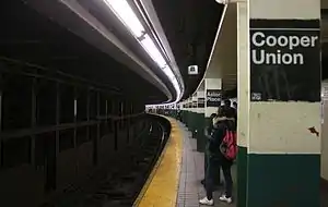
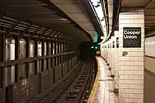
Like other local stations, Astor Place has four tracks and two side platforms. The 6 stops here at all times,[33] rush-hour and midday <6> trains stop here in the peak direction;[33] and the 4 stops here during late nights.[34] The two express tracks are used by the 4 and 5 trains during daytime hours.[35] The platforms were originally 200 feet (61 m) long, as at other local stations on the original IRT,[6]:4[2]:3 but as a result of the 1959 platform extensions, became 525 feet (160 m) long.[27] The platform extensions are at the front ends of the original platforms: the southbound platform was extended southward and the northbound platform was extended northward.[36]:33 Both platforms are slightly curved.[2]:5–6
Design
As with other stations built as part of the original IRT, the tunnel is covered by a "U"-shaped trough that contains utility pipes and wires. The bottom of this trough contains a foundation of concrete no less than 4 inches (100 mm) thick.[2]:3–4[36]:9 Each platform consists of 3-inch-thick (7.6 cm) concrete slabs, beneath which are drainage basins. The original platforms contain circular, cast-iron Doric-style columns spaced every 15 feet (4.6 m), while the platform extensions contain I-beam columns, some clad with white glazed tiles. The columns contain black-and-white signs alternating between "Astor Place" and "Cooper Union". Additional columns between the tracks, spaced every 5 feet (1.5 m), support the jack-arched concrete station roofs.[2]:3–4[6]:4[36]:9 The ceiling height varies based on whether there are utilities in the ceiling; the areas without utilities is about 15 feet (4.6 m) above platform level, while the area with utilities has a ceiling height of 8 feet (2.4 m).[2]:5 There is a 1-inch (25 mm) gap between the trough wall and the platform walls, which are made of 4-inch (100 mm)-thick brick covered over by a tiled finish.[2]:3–4[36]:9
The fare control areas are at platform level and there is no free transfer between directions.[2]:4 An underpass between the platforms was closed in the 1980s.[2]:4[32] The underpass had opened along with the rest of the station in 1904, making Astor Place one of the few locations in the original IRT where passengers could transfer between directions for free.[37]:146
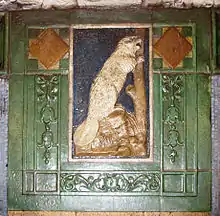
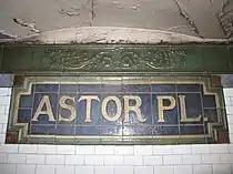
The walls along the platforms near the fare control areas consist of a brick wainscoting on the lowest part of the wall, with bronze air vents along the wainscoting, and white glass tiles above. The platform walls are divided at 15-foot (4.6 m) intervals by buff brick tile pilasters, or vertical bands; the wall sections between each pilaster contain a border of blue mosaic tiles. In the original portion of the station, each pilaster is topped by yellow faience plaques depicting beavers, surrounded by green scrolled and foliate motifs. The beaver plaques are a reference to John Jacob Astor, whose fortune had been derived from the beaver-pelt trade. A faience cornice with green urn and vine motifs runs atop these walls.[2]:4–5[6]:8 Cream-on-blue faience plaques with the words "Astor Place" are also spaced at various intervals on the walls, a deviation from the tile plaques seen at other original IRT stations. The platform extensions contain similar decorative elements, but the pilasters are made of tan ceramic tiles, and the wall sections between each pilaster contain a border of blue ceramic tiles. Within the platform extensions' pilasters are tiled plaques with the vertical text "Astor".[2]:5 There were maroon and gold tile Cooper Union signs underneath the tile Astor Place signs, which were destroyed during the renovation.[38] The decorative work was performed by tile contractor Manhattan Glass Tile Company and faience contractor Grueby Faience Company.[36]:33
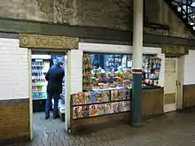
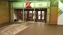
The northbound platform contains doorways that formerly led to men's and women's restrooms, with corresponding marble lintels. A news and candy stand is in the former women's restroom. North of fare control is a rounded seating area.[2]:6 An he northbound platform was used as a cover image of Billy Joel's 1976 album Turnstiles was shot on the uptown side of the station.[39] On the southbound side, the station has an entrance and windows into a K-Mart. This store was originally constructed in 1868 as an A. T. Stewart. It had changed ownership and was a Wanamaker's when the station was constructed. The heavy brick-faced square columns on the downtown platform support the store above.[2]:4–5 The northern building of the Wanamaker's store burned in the 1950s, but the southern building, 770 Broadway, remains extant.[40] The walls in this station contain modern enamel artwork. South of fare control is a doorway with a marble lintel reading "Clinton Hall". This doorway once led to the New York Mercantile Library in the former Astor Opera House.[41][2]:4–5
Exits
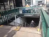
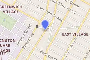
The station has two entrances, one in each direction. The southbound platform's entrance is at the southwest corner of Astor Place and Lafayette Street.[42] The street staircase on the southbound side contains relatively simple, modern steel railings like those seen at most New York City Subway stations.[2]:6
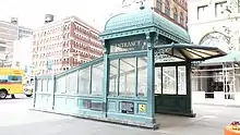
The northbound platform's entrance is in the traffic island bounded by Fourth Avenue, Lafayette Street, and Eighth Street.[42] Unlike the southbound entrance, the northbound entrance contains a highly decorative entrance, reminiscent of an entry kiosk seen on the original IRT.[2]:7[43] The structure is an imitation of the IRT's original entrance and exit kiosks, extremely ornate structures made of cast iron and glass. The IRT kiosks were inspired by those on the Budapest Metro, which themselves were inspired by ornate summer houses called "kushks".[44]:443[45]:66–67 The Astor Place entrance is a reproduction installed in the 1980s, and was made at the same factory as the originals.[2]:7 Like the original entrance kiosks,[36]:13 it has a domed roof with cast-iron shingles.[2]:7
Points of interest
Several sites of historical and cultural importance are near the station, such as New York University and Cooper Union.[46] The Alamo, a cube sculpture above the northbound platform, is a popular visitor attraction in the area.[47] Other points of interest include:
- McSorley's Old Ale House[46]
- Cooper Union New Academic Building[46]
- Cooper Square Hotel[46]
- Public Theater (Astor Library)[46]
- Colonnade Row / Astor Place Theatre (Blue Man Group)[46]
- Kmart (former Wanamaker Department Store Annex)[46]
- Hamilton Fish House[46]
The Eighth Street–New York University station on the BMT Broadway Line is one block west of the station.[46]
In popular culture
An image of the northbound platform was used as a cover image of Billy Joel's 1976 album Turnstiles.[39]
References
- "Borough of Manhattan, New York City". Government of New York City. Retrieved December 28, 2020.
- "New York MPS Astor Place Subway Station (IRT)". Records of the National Park Service, 1785 - 2006, Series: National Register of Historic Places and National Historic Landmarks Program Records, 2013 - 2017, Box: National Register of Historic Places and National Historic Landmarks Program Records: New York, ID: 75313927. National Archives.
- "Our Subway Open: 150,000 Try It; Mayor McClellan Runs the First Official Train". The New York Times. October 28, 1904. p. 1. ISSN 0362-4331. Retrieved April 21, 2020.
- "Station Developers' Information". Metropolitan Transportation Authority. Retrieved June 13, 2017.
- "Facts and Figures: Annual Subway Ridership 2014–2019". Metropolitan Transportation Authority. 2020. Retrieved May 26, 2020.
- "Interborough Rapid Transit System, Underground Interior" (PDF). New York City Landmarks Preservation Commission. October 23, 1979. Retrieved November 19, 2019.
- Walker, James Blaine (1918). Fifty Years of Rapid Transit — 1864 to 1917. New York, N.Y.: Law Printing. Retrieved November 6, 2016.
- Report of the Board of Rapid Transit Railroad Commissioners for the City of New York For The Year Ending December 31, 1904 Accompanied By Reports of the Chief Engineer and of the Auditor. Board of Rapid Transit Railroad Commissioners. 1905. pp. 229–236.
- Gray, Christopher (June 17, 2010). "Along Lafayette Street, Some Very Odd Lots". The New York Times. ISSN 0362-4331. Retrieved February 2, 2021.
- Presa, Donald G. (June 29, 1999). "NoHo Historic District" (PDF). New York City Landmarks Preservation Commission. Retrieved February 2, 2021.
- Hanly, Thomas B. (November 7, 1897). "Elm Street Past and Present" (PDF). The New York Times. p. 32. ISSN 0362-4331. Retrieved February 2, 2021.
- "Elm Street Off the Map" (PDF). The New York Times. April 26, 1905. p. 1. ISSN 0362-4331. Retrieved February 2, 2021.
- Moscow, Henry (1978). The Street Book: An Encyclopedia of Manhattan's Street Names and Their Origins. New York: Hagstrom Company. p. 67. ISBN 978-0-8232-1275-0.
- "Our First Subway Completed At Last — Opening of the Van Cortlandt Extension Finishes System Begun in 1900 — The Job Cost $60,000,000 — A Twenty-Mile Ride from Brooklyn to 242d Street for a Nickel Is Possible Now". The New York Times. August 2, 1908. p. 10. Retrieved November 6, 2016.
- Brooklyn Daily Eagle Almanac. Brooklyn Daily Eagle. 1916. p. 119.
- "Open New Subway Lines to Traffic; Called a Triumph — Great H System Put in Operation Marks an Era in Railroad Construction — No Hitch in the Plans — But Public Gropes Blindly to Find the Way in Maze of New Stations — Thousands Go Astray — Leaders in City's Life Hail Accomplishment of Great Task at Meeting at the Astor" (PDF). The New York Times. August 2, 1918. p. 1. Retrieved November 6, 2016.
- "Map of Hudson & Manhattan Railroad Hudson Tunnel System" (PDF). columbia.edu. Hudson & Manhattan Railroad. December 31, 1912. Retrieved September 5, 2016.
- Cudahy, Brian J. (2002), Rails Under the Mighty Hudson (2nd ed.), New York: Fordham University Press, ISBN 978-0-82890-257-1, OCLC 911046235
- "M'Adoo Subway Wins Fight For Franchise; Crosstown Line Perpetual -- 25 Years Under Sixth Avenue". The New York Times. December 16, 1904. ISSN 0362-4331. Archived from the original on April 24, 2018. Retrieved April 24, 2018.
- D'Orazio, Bernard (April 23, 2018). "In 1874, a Daring Downtown Plan: Build a Train Tunnel Under the Hudson". Tribeca Trib Online. Archived from the original on May 3, 2018. Retrieved May 2, 2018.
- "Trolley Tunnel Open to Jersey; President Turns On Power for First Official Train Between This City and Hoboken". The New York Times. February 26, 1908. ISSN 0362-4331. Archived from the original on April 25, 2018. Retrieved April 24, 2018.
- "M'Adoo's Railroad Slow In Building; Two Months More Time Given for Extension to Grand Central". The New York Times. April 9, 1914. ISSN 0362-4331. Archived from the original on April 26, 2018. Retrieved April 25, 2018.
- Hood, Clifton (1978). "The Impact of the IRT in New York City" (PDF). Historic American Engineering Record. pp. 146–207 (PDF pp. 147–208). Retrieved December 20, 2020.
 This article incorporates text from this source, which is in the public domain.
 - Report of the Public Service Commission for the First District of the State of New York For The Year Ending December 31, 1910. Public Service Commission. 1911.
- "Wanamaker's Fire". norman.hrc.utexas.edu. New York Journal-American. July 15, 1956. Retrieved March 5, 2020 – via Harry Ransom Center at University of Texas at Austin.
Wanamaker's Fire : The scene on the streets as firemen and firetrucks battle the 25-hour long blaze at the old Wanamaker's Department Store.
- Kihss, Peter (July 18, 1956). "Full IRT Service Resuming Friday". The New York Times. ISSN 0362-4331. Retrieved February 2, 2021.
- Annual Report For The Year Ending June 30, 1959 (PDF). New York City Transit Authority. 1959. p. 9.
- "4 IRT Stops To Open Longer Platforms". The New York Times. February 18, 1962. ISSN 0362-4331. Retrieved January 4, 2021.
- "12 IRT Subway Stops Get Landmark Status". The New York Times. October 27, 1979. ISSN 0362-4331. Retrieved December 26, 2020.
- Gargan, Edward A. (June 11, 1981). "Agency Lists Its 69 Most Deteriorated Subway Stations". The New York Times. Retrieved August 13, 2016.
- United Press International (June 8, 1984). "Station at Astor Place Slated for Restoration". The New York Times. ISSN 0362-4331. Retrieved December 29, 2020.
- Blau, Eleanor (May 17, 1986). "Refurbishing of IRT Station Applauded by Well-Wishers". The New York Times. ISSN 0362-4331. Retrieved September 5, 2016.
- "6 Subway Timetable, Effective September 13, 2020". Metropolitan Transportation Authority. Retrieved December 9, 2020.
- "4 Subway Timetable, Effective September 13, 2020". Metropolitan Transportation Authority. Retrieved December 9, 2020.
- Dougherty, Peter (2006) [2002]. Tracks of the New York City Subway 2006 (3rd ed.). Dougherty. OCLC 49777633 – via Google Books.
- Framberger, David J. (1978). "Architectural Designs for New York's First Subway" (PDF). Historic American Engineering Record. pp. 1-46 (PDF pp. 367-412). Retrieved December 20, 2020. This article incorporates text from this source, which is in the public domain.
- Appendices to the Report of the Royal Commission on London Traffic with Index Presented to both Houses of Parliament by Command of His Majesty. Royal Commission on London Traffic. 1906.
- "1982 Photo of Astor Place Signage". Cable (Cooper Union Yearbook). 1982. Retrieved December 9, 2009.
- Katz, Mike, 1962- (June 2018). Rock and roll explorer guide to New York City. Kott, Crispin,, McNeil, Legs. Guilford, Connecticut. p. 150. ISBN 978-1-63076-316-9. OCLC 1007036799.CS1 maint: multiple names: authors list (link)
- "Wanamaker's Fire". norman.hrc.utexas.edu. New York Journal-American. July 15, 1956. Retrieved March 5, 2020 – via Harry Ransom Center at University of Texas at Austin.
Wanamaker's Fire : The scene on the streets as firemen and firetrucks battle the 25-hour long blaze at the old Wanamaker's Department Store.
- "Clinton Hall at Astor Place". Forgotten New York.
- "MTA Neighborhood Maps: Astor Pl (6)". Metropolitan Transportation Authority. 2018. Retrieved December 25, 2020.
- Carlson, Jen (February 20, 2019). "Wowza, Is This The Most Instagrammable Subway Station In NYC?". Gothamist. Retrieved December 22, 2020.
- Stern, Robert A. M.; Gilmartin, Gregory; Massengale, John Montague (1983). New York 1900: Metropolitan Architecture and Urbanism, 1890-1915. New York: Rizzoli. ISBN 0-8478-0511-5. OCLC 9829395.
- Brooks, Michael W. (1997). Subway City: Riding the Trains, Reading New York. Rutgers University Press. ISBN 978-0-8135-2396-5.
- "MTA Neighborhood Maps: East Village" (PDF). mta.info. Metropolitan Transportation Authority. 2015. Retrieved September 5, 2015.
- Bleyer, Jennifer (January 30, 2005). "A Famous Cube Puzzles Its Biggest Fans". The New York Times. Retrieved July 17, 2010.
Further reading
External links
| Wikimedia Commons has media related to Astor Place (IRT Lexington Avenue Line). |
- nycsubway.org – IRT East Side Line: Astor Place
- nycsubway.org — Untitled Artwork by Milton Glaser (1986)
- Station Reporter — 6 Train
- Forgotten NY: Subways and Trains — Original 28 IRT subway stations
- MTA's Arts For Transit — Astor Place (IRT Lexington Avenue Line)
- Fourth Avenue entrance from Google Maps Street View
- Lafayette Street entrance from Google Maps Street View
- Platforms from Google Maps Street View
- Lobby and Kmart entrance from Google Maps Street View
| Lexington Ave. Line |
|
|---|---|
| |
| Topics |  | |
|---|---|---|
| Lists by county |
| |
| Lists by city | ||
| Other lists | ||
| ||