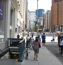
33rd Street station (IRT Lexington Avenue Line)
33rd Street is a local station on the IRT Lexington Avenue Line of the New York City Subway. Located at the intersection of Park Avenue and 33rd Street in the Murray Hill neighborhood of Manhattan, it is served by 6 trains at all times, <6> trains during weekdays in the peak direction, and 4 trains during late night hours.
33 Street | ||||||||||||||||||||||||||||||||||||||||||||||||||||||||||||||||||||
|---|---|---|---|---|---|---|---|---|---|---|---|---|---|---|---|---|---|---|---|---|---|---|---|---|---|---|---|---|---|---|---|---|---|---|---|---|---|---|---|---|---|---|---|---|---|---|---|---|---|---|---|---|---|---|---|---|---|---|---|---|---|---|---|---|---|---|---|---|
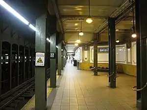 Downtown platform with an Arts for Transit artwork, Lariat Seat Loops, on the columns | ||||||||||||||||||||||||||||||||||||||||||||||||||||||||||||||||||||
| Station statistics | ||||||||||||||||||||||||||||||||||||||||||||||||||||||||||||||||||||
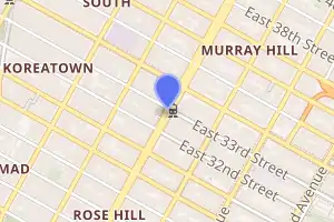
| Address | East 33rd Street & Park Avenue New York, NY 10016[1][2]:1 | |||||||||||||||||||||||||||||||||||||||||||||||||||||||||||||||||||
| Borough | Manhattan | |||||||||||||||||||||||||||||||||||||||||||||||||||||||||||||||||||
| Locale | Murray Hill, Kips Bay | |||||||||||||||||||||||||||||||||||||||||||||||||||||||||||||||||||
| Coordinates | 40°44′47″N 73°58′55″W | |||||||||||||||||||||||||||||||||||||||||||||||||||||||||||||||||||
| Division | A (IRT) | |||||||||||||||||||||||||||||||||||||||||||||||||||||||||||||||||||
| Line | IRT Lexington Avenue Line | |||||||||||||||||||||||||||||||||||||||||||||||||||||||||||||||||||
| Services | 4 6 | |||||||||||||||||||||||||||||||||||||||||||||||||||||||||||||||||||
| Transit | ⛴ NYC Ferry: Astoria and Soundview Routes (on FDR Drive and East 34th Street) | |||||||||||||||||||||||||||||||||||||||||||||||||||||||||||||||||||
| Structure | Underground | |||||||||||||||||||||||||||||||||||||||||||||||||||||||||||||||||||
| Platforms | 2 side platforms | |||||||||||||||||||||||||||||||||||||||||||||||||||||||||||||||||||
| Tracks | 4 | |||||||||||||||||||||||||||||||||||||||||||||||||||||||||||||||||||
| Other information | ||||||||||||||||||||||||||||||||||||||||||||||||||||||||||||||||||||
| Opened | October 27, 1904[3] | |||||||||||||||||||||||||||||||||||||||||||||||||||||||||||||||||||
| Station code | 403[4] | |||||||||||||||||||||||||||||||||||||||||||||||||||||||||||||||||||
| Opposite- direction transfer | No | |||||||||||||||||||||||||||||||||||||||||||||||||||||||||||||||||||
| Traffic | ||||||||||||||||||||||||||||||||||||||||||||||||||||||||||||||||||||
| 2019 | 8,934,900[5] | |||||||||||||||||||||||||||||||||||||||||||||||||||||||||||||||||||
| Rank | 33 out of 424[5] | |||||||||||||||||||||||||||||||||||||||||||||||||||||||||||||||||||
| Station succession | ||||||||||||||||||||||||||||||||||||||||||||||||||||||||||||||||||||
| Next north | Grand Central–42nd Street: 4 Grand Central (shuttle): no passenger service | |||||||||||||||||||||||||||||||||||||||||||||||||||||||||||||||||||
| Next south | 28th Street: 4 | |||||||||||||||||||||||||||||||||||||||||||||||||||||||||||||||||||
| ||||||||||||||||||||||||||||||||||||||||||||||||||||||||||||||||||||
| ||||||||||||||||||||||||||||||||||||||||||||||||||||||||||||||||||||
| ||||||||||||||||||||||||||||||||||||||||||||||||||||||||||||||||||||
| ||||||||||||||||||||||||||||||||||||||||||||||||||||||||||||||||||||
33rd Street Subway Station (IRT) | ||||||||||||||||||||||||||||||||||||||||||||||||||||||||||||||||||||
New York City Landmark No. 1096 | ||||||||||||||||||||||||||||||||||||||||||||||||||||||||||||||||||||
| MPS | New York City Subway System MPS | |||||||||||||||||||||||||||||||||||||||||||||||||||||||||||||||||||
| NRHP reference No. | 04001014[2] | |||||||||||||||||||||||||||||||||||||||||||||||||||||||||||||||||||
| NYCL No. | 1096 | |||||||||||||||||||||||||||||||||||||||||||||||||||||||||||||||||||
| Significant dates | ||||||||||||||||||||||||||||||||||||||||||||||||||||||||||||||||||||
| Added to NRHP | September 17, 2004 | |||||||||||||||||||||||||||||||||||||||||||||||||||||||||||||||||||
| Designated NYCL | October 23, 1979[6] | |||||||||||||||||||||||||||||||||||||||||||||||||||||||||||||||||||

Built for the Interborough Rapid Transit Company (IRT), the 33rd Street station was constructed as part of the city's first subway line, which was approved in 1900. Construction on the segment of the line that includes the 33rd Street station started on September 12 of the same year. The station opened on October 27, 1904, as one of the original 28 stations of the New York City Subway. The station's platforms were lengthened in the late 1940s.
The 33rd Street station contains two side platforms and four tracks; express trains use the inner two tracks to bypass the station. The station was built with tile and mosaic decorations, which are continued along the platform extensions. The platforms contain exits to 32nd Street to the south and 33rd Street to the north. The platforms are not connected to each other within fare control. The original station interior is a New York City designated landmark and listed on the National Register of Historic Places.
History
Construction and opening
Planning for the city's first subway line dates to the Rapid Transit Act, authorized by the New York State Legislature in 1894.[7]:139–140 The subway plans were drawn up by a team of engineers led by William Barclay Parsons, chief engineer of the Rapid Transit Commission. It called for a subway line from New York City Hall in lower Manhattan to the Upper West Side, where two branches would lead north into the Bronx.[6]:3 A plan was formally adopted in 1897, and legal challenges were resolved near the end of 1899.[7]:148 The Rapid Transit Construction Company, organized by John B. McDonald and funded by August Belmont Jr., signed Contract 1 with the Rapid Transit Commission in February 1900,[8] in which it would construct the subway and maintain a 50-year operating lease from the opening of the line.[7]:182 In 1901, the firm of Heins & LaFarge was hired to design the underground stations.[6]:4 Belmont incorporated the Interborough Rapid Transit Company (IRT) in April 1902 to operate the subway.[7]:182
The 33rd Street station was constructed as part of the IRT's original line, particularly the section from Great Jones Street to 41st Street. Construction on this section of the line began on September 12, 1900. The section from Great Jones Street to a point 100 feet (30 m) north of 33rd Street had been awarded to Holbrook, Cabot & Daly Contracting Company, while the remaining section to 41st Street was to be done by Ira A. Shaker.[8] The 33rd Street station opened on October 27, 1904, as one of the original 28 stations of the New York City Subway from City Hall to 145th Street on the Broadway–Seventh Avenue Line.[7]:186[3]
Service changes and station renovations
After the initial system was completed in 1908,[9] the station was served by local trains along both the West Side (now the Broadway–Seventh Avenue Line to Van Cortlandt Park–242nd Street) and East Side (now the Lenox Avenue Line). West Side local trains had their southern terminus at City Hall during rush hours and South Ferry at other times, and had their northern terminus at 242nd Street. East Side local trains ran from City Hall to Lenox Avenue (145th Street).[10] In 1918, the Lexington Avenue Line opened north of Grand Central–42nd Street, thereby dividing the original line into an "H" system. All local trains were sent via the Lexington Avenue Line, running along the Pelham Line in the Bronx.[11]
In 1909, to address overcrowding, the New York Public Service Commission proposed lengthening platforms at stations along the original IRT subway.[12]:168 On January 18, 1910, a modification was made to Contracts 1 and 2 to lengthen station platforms to accommodate ten-car express and six-car local trains. In addition to $1.5 million (equivalent to $41.2 million in 2019) spent on platform lengthening, $500,000 (equivalent to $13,719,643 in 2019) was spent on building additional entrances and exits. It was anticipated that these improvements would increase capacity by 25 percent.[13]:15 Both platforms at the 33rd Street station was extended 27 feet (8.2 m) to the south. New "electric manholes", passageways leading to the equipment closets, were built at the southern ends of the platforms.[13]:108
On April 13, 1948, the platform extensions to accommodate ten-car trains at this station, along with those at 23rd Street and 28th Street, were opened for use.[14] On December 27, 1948, a new entrance to the station at 32nd Street opened for use.[14]
During the early and mid-20th century, the IRT and members of the public proposed that this station be rebuilt as an express stop to reduce overcrowding at the Grand Central–42nd Street station one stop to the north. It was estimated that the extra time spent by express trains at 33rd Street would be offset by the reduced dwell times at Grand Central.[15][16]
In 1979, the New York City Landmarks Preservation Commission designated the space within the boundaries of the original station, excluding expansions made after 1904, as a city landmark. The station was designated along with eleven others on the original IRT.[6][17] The original interiors were listed on the National Register of Historic Places in 2004.[2]
Station layout
| G | Street level | Entrances/exits |
| P Platform level |
Side platform | |
| Northbound local | ← ← | |
| Northbound express | ← | |
| Southbound express | | |
| Southbound local | | |
| Side platform | ||
Like other local stations, 33rd Street has four tracks and two side platforms. The 6 stops here at all times,[18] rush-hour and midday <6> trains stop here in the peak direction;[18] and the 4 stops here during late nights.[19] The two express tracks are used by the 4 and 5 trains during daytime hours.[20] The platforms were originally 200 feet (61 m) long, as at other local stations on the original IRT,[6]:4[2]:3 but later became 520 feet (160 m) long.[14] The platform extensions are at the southern ends of the original platforms.[21]:35 The express tracks stay level, while the local tracks slowly incline from south to north to allow for the easier deceleration of local trains. This results in a layout where the express tracks are at a lower elevation than the local tracks in the northern half of the station.[22] North of the station, the two pairs of tracks in each direction separate into different tunnels because of the presence of the Murray Hill Tunnel, which runs under the center of this section of Park Avenue.[20]
Design
As with other stations built as part of the original IRT, the tunnel is covered by a "U"-shaped trough that contains utility pipes and wires. The bottom of this trough contains a foundation of concrete no less than 4 inches (100 mm) thick.[2]:3–4[21]:9 Each platform consists of 3-inch-thick (7.6 cm) concrete slabs, beneath which are drainage basins. The original platforms contain I-beam columns spaced every 15 feet (4.6 m), while the platform extensions contain columns with white glazed tiles. Additional columns between the tracks, spaced every 5 feet (1.5 m), support the jack-arched concrete station roofs.[2]:3–4[6]:4[21]:9 The ceiling height varies, being about 15 feet (4.6 m) above platform level near the northern fare control areas, and lower in other portions of the station.[2]:5 There is a 1-inch (25 mm) gap between the trough wall and the platform walls, which are made of 4-inch (100 mm)-thick brick covered over by a tiled finish.[2]:3–4[21]:9
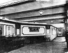
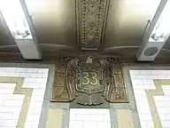
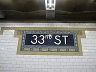
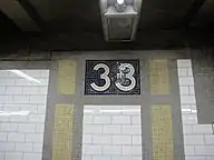
The fare control areas are at platform level, and there is no crossover or crossunder between the platforms.[2]:4 The walls along the platforms near the fare control areas consist of a brick wainscoting on the lowest part of the wall, with bronze air vents along the wainscoting, and white glass tiles above. The platform walls are divided at 15-foot (4.6 m) intervals by buff and green mosaic tile pilasters, or vertical bands. In the original portion of the station, each pilaster is topped by green faience plaques depicting eagles, an allusion to the former 71st Regiment Armory at Park Avenue and 33rd Street; the eagles hold blue and white shields containing the number "33". A cornice with yellow and brown vine and fretwork patterns runs atop these walls.[2]:4–5[6]:8 The platform extensions contain tiles with the number "33" atop the pilasters. Mosaic plaques with the words "33rd St." are also spaced at various intervals on the walls.[2]:5 The decorative work was performed by tile contractor John H. Parry and faience contractor Grueby Faience Company.[21]:35 The ceilings of the northern fare control areas contain plaster molding.[2]:4–5[21]:10
The 1997 artwork at this station is Lariat Seat Loops by James Garvey. These are composed of fourteen bronze loops surrounding the I-beam columns near the northern fare control areas, which are designed as handholds or seat rests.[23][24] According to Garvey, "the thick bronze bar ... resembles the lasso demonstration in a Will Rogers film clip".[24]
| 33rd St to 34th St subway cross-section | |||||||||
| 11th Av | 10th & 9th Avs are skipped |
8th Av | Madison Square Garden |
7th Av | Storefronts | 6th Av & Broadway |
5th & Madison Avs are skipped |
Park Av | |
| mezzanine | A / C / E | concourse | 1 / 2 / 3 | Former Gimbel's passageway |
mezz | PATH | 6 / <6> | ||
| mezzanine | mezzanine | concourse | mezzanine | N / Q / R / W | |||||
| 7 / <7> | Penn Station | B/D/F/<F>/M | |||||||
Exits
Each platform has exits to both 32nd and 33rd Streets; the northbound platform's exits are on the eastern side of Park Avenue while the southbound platform's exits are on the western side. At 33rd Street, each control area contains two exits, one each to the north and south sides of 33rd Street. At 32nd Street, each control area contains two exits to the south side of that street.[2]:4[25] The street staircases contain relatively simple, modern steel railings like those seen at most New York City Subway stations.[2]:6
References
- "Borough of Manhattan, New York City". Government of New York City. Retrieved December 28, 2020.
- "New York MPS 33rd Street Subway Station (IRT)". Records of the National Park Service, 1785 - 2006, Series: National Register of Historic Places and National Historic Landmarks Program Records, 2013 - 2017, Box: National Register of Historic Places and National Historic Landmarks Program Records: New York, ID: 75313919. National Archives.
- "Our Subway Open: 150,000 Try It; Mayor McClellan Runs the First Official Train". The New York Times. October 28, 1904. p. 1. ISSN 0362-4331. Retrieved April 21, 2020.
- "Station Developers' Information". Metropolitan Transportation Authority. Retrieved June 13, 2017.
- "Facts and Figures: Annual Subway Ridership 2014–2019". Metropolitan Transportation Authority. 2020. Retrieved May 26, 2020.
- "Interborough Rapid Transit System, Underground Interior" (PDF). New York City Landmarks Preservation Commission. October 23, 1979. Retrieved November 19, 2019.
- Walker, James Blaine (1918). Fifty Years of Rapid Transit — 1864 to 1917. New York, N.Y.: Law Printing. Retrieved November 6, 2016.
- Report of the Board of Rapid Transit Railroad Commissioners for the City of New York For The Year Ending December 31, 1904 Accompanied By Reports of the Chief Engineer and of the Auditor. Board of Rapid Transit Railroad Commissioners. 1905. pp. 229–236.
- "Our First Subway Completed At Last — Opening of the Van Cortlandt Extension Finishes System Begun in 1900 — The Job Cost $60,000,000 — A Twenty-Mile Ride from Brooklyn to 242d Street for a Nickel Is Possible Now". The New York Times. August 2, 1908. p. 10. Retrieved November 6, 2016.
- Brooklyn Daily Eagle Almanac. Brooklyn Daily Eagle. 1916. p. 119.
- "Open New Subway Lines to Traffic; Called a Triumph — Great H System Put in Operation Marks an Era in Railroad Construction — No Hitch in the Plans — But Public Gropes Blindly to Find the Way in Maze of New Stations — Thousands Go Astray — Leaders in City's Life Hail Accomplishment of Great Task at Meeting at the Astor" (PDF). The New York Times. August 2, 1918. p. 1. Retrieved November 6, 2016.
- Hood, Clifton (1978). "The Impact of the IRT in New York City" (PDF). Historic American Engineering Record. pp. 146–207 (PDF pp. 147–208). Retrieved December 20, 2020.
 This article incorporates text from this source, which is in the public domain.
 - Report of the Public Service Commission for the First District of the State of New York For The Year Ending December 31, 1910. Public Service Commission. 1911.
- Report for the three and one-half years ending June 30, 1949. New York City Board of Transportation. 1949. hdl:2027/mdp.39015023094926.
- Supreme Court Appellate Division-Second Department. pp. 458–460.
- ERA Headlights. Electric Railroaders Association. 1956.
- "12 IRT Subway Stops Get Landmark Status". The New York Times. October 27, 1979. ISSN 0362-4331. Retrieved December 26, 2020.
- "6 Subway Timetable, Effective September 13, 2020". Metropolitan Transportation Authority. Retrieved December 9, 2020.
- "4 Subway Timetable, Effective September 13, 2020". Metropolitan Transportation Authority. Retrieved December 9, 2020.
- Dougherty, Peter (2006) [2002]. Tracks of the New York City Subway 2006 (3rd ed.). Dougherty. OCLC 49777633 – via Google Books.
- Framberger, David J. (1978). "Architectural Designs for New York's First Subway" (PDF). Historic American Engineering Record. pp. 1-46 (PDF pp. 367-412). Retrieved December 20, 2020. This article incorporates text from this source, which is in the public domain.
- Lavis, Fred (1914). "The New York Rapid Transit Railway Extensions". nycsubway.org. Engineering News. Retrieved May 31, 2018.
- Reif, Rita (March 2, 2003). "Art/Architecture; Adorning the Streets With Ropes of Bronze". The New York Times. ISSN 0362-4331. Retrieved December 24, 2020.
- "33rd Street - James Garvey - Lariat Seat Loops, 1997". web.mta.info. Metropolitan Transportation Authority. Retrieved December 24, 2020.
- "MTA Neighborhood Maps: 33 St (6)". Metropolitan Transportation Authority. 2018. Retrieved December 25, 2020.
Further reading
- Lee Stokey. Subway Ceramics: A History and Iconography. 1994. ISBN 978-0-9635486-1-0
External links
| Wikimedia Commons has media related to 33rd Street (IRT Lexington Avenue Line). |
- nycsubway.org – IRT East Side Line: 33rd Street
- Station Reporter — 4 Train
- Station Reporter — 6 Train
- Forgotten NY — Original 28 - NYC's First 28 Subway Stations
- MTA's Arts For Transit — 33rd Street (IRT Lexington Avenue Line)
- 32nd Street entrance from Google Maps Street View
- 33rd Street entrance from Google Maps Street View
- downtown platform from Google Maps Street View
| Lexington Ave. Line |
|
|---|---|
| |
| Topics |  | |
|---|---|---|
| Lists by county |
| |
| Lists by city | ||
| Other lists | ||
| ||